Archaeological travel guide to ancient Vesali (Waithali), the second capital of the Rakhine people in western Myanmar over 1000 years ago.

Wedged into the narrow alluvial plain between mountain ranges in the western frontier of Myanmar is the homeland of the Rakhine, an ethnic that group maintained its independence from the surrounding powers of India and Burma for much of its existence, ruling from its successive capitals in Dhanyawadi, Vesali, and Mrauk U.
The ancient walled city of Vesali served as the second capital of the Rakhine Kingdom from the 6th-10th Centuries CE. During this period, the kingdom prospered becoming a major Buddhist pilgrimage site as it welcomed influence from India, maritime trade routes, and expansion of its territory into eastern Bengal.
The remote ruins of Vesali have become a cautionary tale of sorts for me to do as much research as possible before arriving in these ancient cities. There was so much more about Vesali that I missed, in fact, I’m sure I missed more than I saw.
Contents
The Story of Ancient Vesali (Waithali)
“Having built a city
– Anandacandra Stone, Verse 21, describing Vesali
which is more beautiful and splendid
than the city of the celestial beings
as if mocking the latter city . . .”

A Brief History of the Rakhine Kingdom
Main Article: Cultural Profile: Rakhine, Buddhist Kingdom of Western Myanmar
The Rakhine people (also commonly known by the anglicized Arakan) are a related but distinct ethnic and linguistic group in present-day western Myanmar on the border of Bangladesh. Prior to the colonization of the entire region by the British, the Rakhine people had maintained their own continuous state in the region for nearly 2000 years and over four capitals, the most recent of which is Mrauk U. Its predecessors were, in order, Dhanyawaddy (Dhanyawadi), Vesali (Waithali), and a series of successive cities along the Lemro river, known collectively as the Lemro Period cities.
The Ancient City of Vesali
Vesali is located approximately 26 km south of its predecessor, Dhanyawadi. LIke Dhanyawadi, Vesali was a walled city with a roughly oval shape lined with brick walls and a moat. Excavations of the city wall and its enclosed 6.23 square kilometers enclosure took place in the 1980s. These excavations uncovered many artifacts, coins, and architecture, including several brick structures.

Among the brick structures inside the city is a walled inner city, presumably the palace area where the upper-class members of the city would live. A similar walled inner city was also found in Dhanyawadi. This area is now built over by the modern village of Waithali, preventing large-scale excavation, however, ancient bricks are still visible in many paths and open areas around the modern village.
Both Dhanyawadi and Vesali bear many similar features to the Pyu walled cities in Central Myanmar. Both cultures’ cities contain such a walled inner city within the outer city wall – and it is presumed the lower classes utilize the land within the outer city wall for agriculture.
However, the most noteworthy example of these shared design elements is the curved gateway located in the city gates. This is a feature found at the Rakhine cities of Dhanyawadi and Vesali, as well as the Pyu cities of Beikthano, Sri Ksetra, and Hanlin – but nowhere in other neighboring cultures to the east or west of these two.
The pride of Vesali is the Great Vesali Image, a statue depicting a seated Buddha carved from a single stone. The statue measures ~5.2 meters tall and is housed to this day in a modest temple on the northwest side of Vesali.
The Dating of Vesali
Like its predecessor at Dhanyawadi, there is some discrepancy in the dating of Vesali. It is generally agreed by both archaeologists and Rakhine tradition that Vesali was settled after Dhanyawadi, however, the date is still up in the air.
Local tradition places the founding of Vesali in 327 CE, and is advertised as such at the Temple of the Great Vesali Image. However, this same tradition also places the founding of Dhanyawad as far back as 3000 BCE. The first written historical record comes in the form of a List of Kings found on the Anacandra Inscription, which dates from ~729 CE. While it was originally in Vesali, the Anacandra Inscription is now at the Shitthuang Temple in Mrauk U.

Studies of art styles and coins discovered in the excavations at Vesali find many parallels to the Gupta art style in India. It’s known that the Rakhine area was heavily influenced by India from its earliest days, and this style in Vesali aligns it with the 6th Century CE, leading to the most commonly held dates 500-1000 CE for the city’s height.
The last piece in the puzzle is a piece of wood excavated from a gate post on the northeastern wall of the city. This gate is of a different style than the curved northern gate, instead consisting of a break in the city wall lined with 2 wooden post holes.
This wood was carbon dated to around ~1350 CE, over 2 centuries after most estimates of when Vesali’s walled city had been abandoned. While this doesn’t necessarily affect the founding date discussed early, it is evidence that Vesali remained inhabited and fortified well into the Lemro Period, when political power had shifted elsewhere.
The Rakhine Kingdom in the Vesali Period (6th-10th Centuries CE)
Following the decline of Dhanyawadi, the power center of Rakhine shifted to Vesali around the 500s CE, where it reached a kind of early Golden Age for Rakhine. Their influence was spread throughout the Kaladan and Lemro River Valleys and even into the neighboring Chittagong region in the west of modern Bangladesh.
During this same period, Indianized civilizations that had sprung up throughout the rest of Southeast Asia were also maturing as they flourish off of the China-India maritime trade routes. As such, the Vesali-period Rakhine were contemporaries of the Pyu in Myanmar, the Dvaravati in Thailand, the Chenla in Cambodia, and the Champa in Vietnam.
Several common motifs found on Vesali art and coins art also found throughout coins from the nearest of these neighbors, including in Chittagong, Pyu in central Myanmar, Dvaravati in Thailand, and as far Champa territory in coastal Vietnam.
The Decline of Vesali
Following this early age of prosperity for the Rakhine Kingdom, the city began to wane in influence during the 10th Century CE. At this time, the Rakhine’s long political core near the low-lying banks of the Kaladin River began shifting higher into the low hills of the Arakan Yama range along the Lemro River.
It is also noted that this coincides with the rise of Bagan as a powerful empire and pilgrimage site in Central Myanmar. Along with that, the hills in the upper Lemro River lead to the most direct overland route through the mountains to Bagan. This has led to some historians concluding that Vaishali’s decline in power was due to a takeover in some fashion by Bagan. However, no written records or archaeological evidence seems to corroborate this.

Visiting Ancient Vesali (Waithali)
To stumble unexpectedly upon tales of a Lost City, especially one that you’ve never heard of before, is an exciting prospect. This is particularly true when the storied locale is notably more ancient than the seemingly remotest of ruins you already happen to be in.
This situation presented itself when I was visiting Mrauk U, a town in western Myanmar that had become a historical backwater filled with monumental, semi-abandoned temples. Mrauk U is not a simple place to get to as roads and even entire sections through the country are routinely closed off due to ongoing ethnic conflicts. The journey instead required a 7-hour boat ride upstream on the Kaladan River from the Rakhine provincial capital of Sittwe.
While in the ruined city of Mrauk U, I was told it was merely the fourth and final Rakhine capital, and therefore relatively recent. However, upon hearing of an earlier capital nearby, described by the ancient Rakhine themselves as “more splendid and beautiful than the city of the gods”, I had to see it.
Map of Ancient Vesali
Setting Out from Mrauk U
Starting early afternoon from the Lay Myoe River Guesthouse, I rented a bicycle for $2 and was off down the rough road into the backwaters of the already exceedingly remote Rakhine State. Beyond the familiar stupas, broadly known as paya here, the monuments became sparser as I passed through the former city wall.

My map told me there was a fortress nearby before I crossed a stream. However, 20 minutes of climbing hills through the dense forest brought me to yet another hidden stupa and a number of exceptionally large spiders in their webs, which I almost ran into. No sign of the fortress loomed over the upward horizon. When the grass nearby began to rustle more and more, I figured it was time to make haste back on my way to Vesali.


Through the countryside were vast tracts of farmland, a new rail route being built, and the occasional roadside drink stand. The route wasn’t overly difficult, and most of it was very flat. The only complications were the trucks and motorcycles which all competed for space on the single-lane road. And, as per Murphy’s Law, many always seemed to show up at the same time.
The Northern City Gate of Vesali

After a little over an hour, I arrived at the northern gate of the ancient city, marked with 2 signs claiming the Northern Gates and pointing the way to the “The Great Vesali Image”. The little information I had on it was what I had seen at the Mrauk U Museum, what a few locals had told me, and one brief blurb in a guidebook (there was no internet in Mrauk U at the time).
One thing the guidebook had said was that the city walls of Vesali were well-preserved. However, nothing stood except the outline of the gate’s foundation with some of the topsoil brushed away.
This northern city gate is one of the curious inward-curved gates only found in Pyu and Rakhine settlements. The purpose for this is still unknown — whether it was for a ceremony, defense, or simply a popular aesthetic. However, I would see this again a few weeks later at the Pyu city of Hanlin.

At the time, my experience with city walls was almost entirely limited to the reconstructed walls of Chiang Mai in Thailand and the walls I had seen in Mrauk U. My initial reaction was that if what they consider “well-preserved”, what spectacular state must they say the fully-standing ruins of Mrauk U to be in?
Of course, I missed the long stretches of brick wall foundations that stretch off toward the hills in the east, and even more in the southeast of the ancient city.

The pavement next to gave way to a dirt road leading inside what would have been the city wall. Very little dotted the road other than a few working locals who gladly smiled and waved as I passed by. As had become a curiosity here, the people often called out, “Bye bye!” rather than “Hello!”
The Temple of the Great Vesali Buddha Image
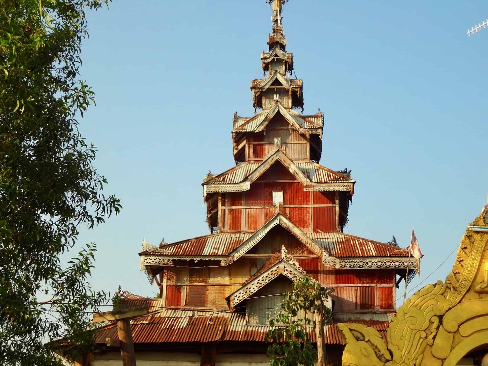
A tiered, red temple reminiscent of a pagoda tower had been growing on the horizon for some time, and now I was finally there. A sign in the front confirmed that I had arrived at the Great Vesali Image. However, up close, the temple was not how it had looked in the distance.
While the enclosure wall surrounding the temple looked as if it could have been an ancient city wall, the building’s walls and roof were made of corrugated sheet metal, much of it had rusted through, unintentionally adding to the temple’s reddish hue on the horizon.


In stark contrast to the building’s weathered exterior, inside were polished white tiled floors and ceilings, faux-golden pillars, and a man eager to show me to the Buddha image. Telling me the ancient date already posted outside and then himself marvelling at its height, he left to return to the tiled hall.
It’s safe to say I’ve seen a lot of Buddha statues in Asia, but stylistically Burmese statues do tend to have a unique quality to them, and those from Rakhine seem to have a special significance. The Mahamuni Image from Vesali’s predecessor city is still the most revered Buddha image in Myanmar.
However, the Great Vesali Image has its own legend behind it, as the monk was all too happy to explain. As the story goes, this image was cut from a single piece of stone by the Rakhine king to appease his Indian wife after an identical Buddha image being shipped from her home in India was lost to the river near Mrauk U.


It wouldn’t surprise me at all if it had been carved from a single piece of stone. Honestly, I wouldn’t be all that impressed if it were. But, it was impossible to tell under the centuries of upkeep and gold paint covering it.
More than that casting doubt on the story was that, to my knowledge, the Buddha in the river had never been recovered. If the Burmese could recover the 23-ton Maha Gandha bronze bell lost to the ocean by the British, a statue in shallow water shouldn’t be too hard.
Modern Waithali, Ancient Vaishali’s Inner Palace City
Following the road further into Vesali, there was a very obvious lack of any informational signage past the Great Vesali Image. A good number of interesting items have been dug up at Vesali. Most were now on display at the Mrauk U Museum or the museum in Sittwe. However, there was nothing on this site indicating where any of these items might have been found.
I continued down the ever-diminishing dirt road until it came to what I supposed was a bridge. The foundation of either a collapsed or unfinished bridge stood up from the small creek and was crossed by a series of rotting boards and 2 beams of broad metal. I wasn’t taking the bike across there.

Walking over, I entered the modern village of Vesali, the walled inner city that had once been the palace of the Rakhine kings. Of course, I did not know this at the time and I honestly got the feeling that much had changed there in 1500 years. With the exception of power lines running to some of the homes, most of the houses looked like they could have been straight out of Vesali’s golden age.


Passing numerous homes, a couple of small reservoirs, and several people making bamboo walls or fences, I reached the end of the main road, but there was no indication of anything archaeological.
Sanghayana Hill
On the way back toward the northern gate, a number of signs in Burmese pointing down a small road stopped me. The sun was going down and I still had a long ride back, but as long as I was here I might as well check it out. The road gave way to a flight of stairs up the slope of a hill. I imagined it might be a kind of palace mound, so went up to see what was on top.
Unfortunately, what was on top most certainly was ancient, not even as old as those found in Mrauk U. At the summit were a handful of wooden buildings and a blue building serving as another temple. No ancient citadel or palace monuments stood atop this mound.


On the way back down to my bike, I did manage to notice the unmistakable angles and colors of bricks sticking out from the side of the hill. I highly doubt that the hill was constructed entirely with bricks, but perhaps a retaining wall once adorned the side of the natural mound. It was a fair assumption that it would have been the central palace mound in antiquity.
With that last observation, I was riding into the rapidly-setting sun back to Mrauk U, stopping once again at the north gate to gaze and chuckle at perhaps the only structural remnant of Vesali, a city which its own king claimed to mock the city of the gods: that “well-preserved” city wall buried in the dirt.
“…more beautiful and splendid than the city of the celestial beings”
Other Areas of Interest in Ancient Vesali
All of the areas I visited in Vesali were located in the northeastern quadrant of the city, although I had ridden on the paved road through the heart of ancient Vesali without even knowing it. I hope that since my visit, they might have posted more informational signs to aid visitors in finding the city’s historical sites.
Some sites of particular interest:
Excavated Items on Display
Located near the southern end of modern Waithali village, this is a small temple lot displaying many of the sandstone sculptures excavated during the village’s history.
Excavation Site 6
Located at the northeastern corner of Vesali’s outer wall, this is the city gate which was carbon dated to the 1400s CE, proving later occupation.
Stone & Brick Mound/Brick Ruins
Brick structures located outside the inner city wall to the southeast.
How to Get to Ancient Vesali (Waithali)
GPS Coordinates: 20.674032, 93.152182

Ancient Vesali is located about 10 kilometers north of Mrauk U, the only town of any significance in the region, and where any visitors are likely to be staying. Several guest houses and hotels in Mrauk U will sell a combination day trip tour package to Vesali and the Mahamuni Temple in Dhanyawadi, which is 23 kilometers farther north.
A more enjoyable way is to simply get there yourself. Bicycles and the occasional motorbike can be rented in Mrauk U. The road from Mrauk U to Vesali is an exceptionally pleasant ride through the Rakhine countryside. The entrance to Vesali is marked by a large red and gold sign in English marking the north gate of the ancient city.
Only the very foundations of the gate remain. Following the dirt road through the ancient gate will bring you into modern Vesali, where you can see the descendants of its ancient inhabitants and their religious icons, including their revered “Great Vesali Image” Buddha statue.
Fast Facts

Glossary
Bamar
Ethnic group that makes up the majority of Myanmar’s population. Commonly known as Burmese.
Dhanyawadi
The first capital city of Rakhine. While tradition places its founding around 3000 BCE, archaeologists date it to the early 1st Millennium CE.
Great Vesali Image
Rakhine Buddha image located in Vesali, Myanmar.
Maha Gandha bronze bell
Massive bronze bell stolen by the British but lost to the Irrawaddy River.
Mahamuni Image
Rakhine Buddha originally from Dhanyawadi, taken by conquering Burmese and relocated to Mandalay.
Mahamuni Temple (Dhanyawadi)
Ancient temple in Dhanyawadi that once housed the Mahamune Image.
Mahamuni Temple (Mandalay)
Temple in modern Mandalay that now houses the Mahamune Image.
Mrauk U
Fourth and final capital of the independent Rakhine kingdom from 1430-1785 CE.
Rakhine Kingdom
Independent kingdom located in the Kaladin-Lemro River Valleys of Western Myanmar.
Rakhine State
Modern state located in Western Myanmar.
Sittwe
Capital city of Myanmar’s Rakhine State.
stupa
Buddhist monument used to enshrine sacred relics or memorialize important figures. Its dome, bell, or otherwise tower-like appearance is an architectural representation of Mount Meru, the cosmic mountain said to represent the structure of the universe in Hindu-Buddhist cosmology.
Vesali
Second capital of the Rakhine kingdom from ~6th-10th Centuries CE.
Sources
- Htin, Kyaw Minn. “‘Historical Geography and Urbanization in Ancient Arakan: the Archaeological Landscape of the Old Capitals up to 1400 AD’. Aséanie 20 (December 2007), 55-73.” Academia.edu, www.academia.edu/22518599/_Historical_Geography_and_Urbanization_in_Ancient_Arakan_the_archaeological_landscape_of_the_old_capitals_up_to_1400_AD_As%C3%A9anie_20_December_2007_55_73.
- Hudson, Bob. “Hudson 2005 Ancient Geography and Recent Archaeology: Dhanyawadi, Vesali and Mrauk.” Academia.edu, www.academia.edu/2411471/Hudson_2005_Ancient_geography_and_recent_archaeology_Dhanyawadi_Vesali_and_Mrauk_u.
- Pike, John. “Myanmar – Arakan Kingdom – Chandra Dynasty – AD 327-957 .” GlobalSecurity.org, www.globalsecurity.org/military/world/myanmar/history-chandra.htm.


