Historical travel guide to Fort Holmes, a reconstructed Colonial-era fort on Mackinac Island that defended the Great Lakes during the War of 1812.

The Straits of Mackinac have long played an important role in the history of the Great Lakes. Long before the arrival of the European colonists, Mackinac Island was a sacred island to the local Native tribes, who buried their dead in the caves on the island.
Fort Holmes is a reinforced earthen redoubt built at the highest point of Mackinac Island. From this vantage point, soldiers at Fort Holmes should view in all directions of the island, able to protect the otherwise undefended rear of Fort Mackinac and Mackinac Island. After 7 years in service, Fort Holmes was abandoned in 1817.

Following its abandonment, there were several attempts two revitalize Fort Holmes for both military and tourist purposes. However, despite the fort’s appealing location and historical significance, these renovations never seemed to have the lasting effects they intended for.
Yet, Fort Holmes remains an iconic location and one of the historical highlights on Mackinac Island. Its recent reconstruction in 2015 has rekindled its reputation and Fort Homes is certainly worth a visit for any of the thousands of visitors to Mackinac Island each year.

The Story of Mackinac Island’s Fort Holmes
Fort Holmes is located on Mackinac Island, the historically most significant island in the Straits of Mackinac. In 1779, during the Revolutionary War, when the British controlled the island, their engineers and Lieutenant Governor noted an exploitable weakness at the highest point on the island — it granted a dangerous strategic advantage by overlooking the undefended rear of Fort Mackinac. This observation was noted by the British in both 1779 and 1788, and again by the Americans in 1796. However, nothing was done to reinforce this location.
In the War of 1812, when the British came began taking control of the Straits, they launched an attack on the then American-controlled Mackinac Island. Fort Mackinac is a longstanding fortification built on a cliff strategically overlooking both the harbor of Mackinac Island, and the entirety of the shipping lanes in the Straits of Mackinac.
However, Fort Mackinac had an exploitable weakness: it only faced south. The north side of Mackinac Island is comparably flat with a much more gradual slope than the main harbor. By landing their troops on the north side of the island and gaining a strategic advantage with the high ground over the undefended rear of Fort Mackinac, the Americans surrendered the Island to he British, who, in turn, built the would-be Fort Holmes to prevent their enemies from exploiting the island’s same weakness.

British Fort George During the War of 1812
After taking Mackinac Island in an attack from the island’s vulnerable northern shore, the British sought to reinforce their position with another fortification at the point that had cost led to their invasion’s victory. At the highest point on the island, they began building a reinforced blockhouse redoubt to supplement the defenses of the now British-controlled Fort Mackinac.
In the summer of 1814, the Americans launched an attack, the Battle of Mackinac Island, to retake the island and, therefore, the Straits of Mackinac. During this battle, Major Andrew Holmes (second in common) was killed on August 4, 1814. After the end of the war and return of the island to the Americans, Fort George was renamed “Fort Holmes” in remembrance of Major Holmes.
American Fort Holmes after the War of 1812
Following the stalemate victory of the War of 1812, the British retreated to their former Canadian border, while the American Army returned to occupy both Fort Mackinac and Fort Holmes on Mackinac Island on July 18, 1815. During this time, the Americans further reinforced Fort Holmes in a similar manner to plans the British had to expand the redoubt.
In 1817, Major Charles Gratiot surveyed the fort and recommended additions to further expand the fort. However, these plans were not implemented in 1817 before the fort was shut down for the winter, as it had no water supply or sleeping accommodations. Fort Holmes was not reopened the following summer, leading to its eventual decline.
Little occurred following this time, and looking back retrospectively, we can see that no further conflict occurred between the British and Americans. Following this brief occupation, Fort Holmes was abandoned, as there was no longer a need for it to defend Fort Mackinac. Its arms were relocated to Fort Mackinac and some of the wood was used to build a barn below the fort near the town. Without maintenance, the remaining wooden structures at Fort Holmes later rotted away.
The Structure of Fort Holmes
At the time Fort Holmes was constructed, much of Mackinac Island had been cleared of trees, a shocking thing to think of now, considering over 90% of the modern island is state park forest. The immediate area around Fort Holmes was kept cleared to provide soldiers stationed there a 360° view for firing as well as observation of the surrounding straits and island, including downhill at Fort Mackinac and the island harbor as well as British Landing, the northern shore from which the British had taken the island.

At the edge of the clearing surrounding Fort Holmes were a barrier of chopped-down trees that had their branches tied together (abattis), forming a thick wall of natural materials to defend the clearing. Accompanying these were 2 artillery turrets placed at strategic vantage points along the edge of the hilltop.
The center of the clearing contained the main fortification, which was first constructed as a horseshoe-shaped earthwork, with the only gate facing southeast, away from British Landing, where enemy troops could advance from and toward the cliff overlooking Fort Mackinac. This earthwork was surrounded by a ditch, a wall of vertical logs, and topped off with a wall of horizontal logs carved into points, preventing anyone from scaling the wall easily.
Fort Holmes as a Blockhouse Fort

The inner structure of Fort Holmes is a blockhouse, a defensive structure originating in England after the advent of gunpowder into warfare. The general idea of a blockhouse was to form a defensive line of sight in all directions, so that troops stationed there may fire at any advancing enemy.
The British implemented blockhouses in the Americas as a strategic way of defending against Native Americans. These were made of wood and often had some difference between the first and second stories to easy access to any ground-level fires which might be set at the base.
The diagonal second level of the Fort Holmes blockhouse provides a complete scope of view and capability of firing at any forces that might have breached the outer fortifications. However, as noted above, the fort never saw any action, either as Fort George or Fort Holmes.
Fort Holmes as a Part of Mackinac Island State Park

Decades after its abandonment, the top of Mackinac Island was still popular with tourists. A military survey tower was built in 1841, though it became a popular sightseeing spot given its view of the island and straits.
Eventually, the entirety of Mackinac Island was placed under the protection of the Michigan State Park service. Several subsequent towers were built until the tallest at 70 feet was built with an accompanying souvenir stand in 1898. The State Park ordered it be reduced by 20 feet in 1908, but it was taken down entirely in 1908 — however, true to Mackinac ISland tradition, the souvenir stand was still there another 10 years until 1918.
Throughout the 1900s, there were a few attempts to rebuild the fort. The first of these was in 1907, when the State Park Commission returned the wood from the original structure to Fort Holmes. For the last 80+ years, this wood had been serving as a barn near the island’s main town. It was used to rebuild a building closely resembling the same barn within the old earthwork wall of Fort Homes.
When the original wood burned away in a 1934 fire, the Park Commission opted to make a more accurate reconstruction based on the surveys done in 1817. This reconstruction was completed in July 1936, ushering in another era of tourism to Fort Holmes.
By the 1960s, this reconstruction was showing definitive signs of decay from years of neglect. It was once again dismantled by the State Park Commission, leaving only the original earthwork and wooden gate on the site of Fort Holmes.


In 2015, a complete reconstruction of Fort Holmes took place to commemorate the bicentennial of the end of the War of 1812.
Visiting Mackinac Island’s Fort Holmes

During the time I lived and worked on Mackinac Island, Fort Holmes was little more than a round earthwork where the wooden fortification used to be. The wooden posts that made up the fort had long since rotted away or repurposed for other things.
However, during a return to Michigan in 2018, I travelled to the island with my old friend Jason, a history enthusiast who had previously studied the revolutionary era and early American History. One of his concentrations was the history of that era in the Great Lakes.

Weather in the Great Lakes is temperamental, and that’s being kind. There is a longstanding anecdote in my home city of Grand Rapids that it can be summer weather one day then snowing the next. the weather of the Straits of Mackinac is even more so. It was a sunny and pleasant day as Jason and I had ridden the ferry to Mackinac Island the afternoon before.
Being from Grand Rapids, Jason visited Mackinac Island during the time I lived there as well. After our ferry ride, we went out for dinner and then that night into the ever-present Mackinac Island bar scene, meeting up with some familiar faces along the way.

The next morning, it was a grey and cloudy doomscape over the entire Straits. A cold wind and a light drizzle were over the town, but nothing that would keep us inside or even warrant a jacket. So, we headed out onto Main Street toward Fort Homes.
The Road to Fort Holmes

The entirety of Mackinac Island is essentially one limestone outcropping rising up from Lake Huron. Because of this, the immediate shoreline is the only truly flat part of the island. This type of limestone karst makes for some very amazing rock outcroppings scattered around the island.
However, it also means that the roads are endlessly inclined and rarely straight. From our hotel in the main town of Mackinac Island, we walked the trail toward the interior of the island, passing Fort Mackinac, which dominates the entire harbor town.
There are 2 main ways to approach Fort Holmes — either the direct stairs up the hill or a gradual sloping road which makes the fight accessible to the island’s iconic bikes and horse carriages.
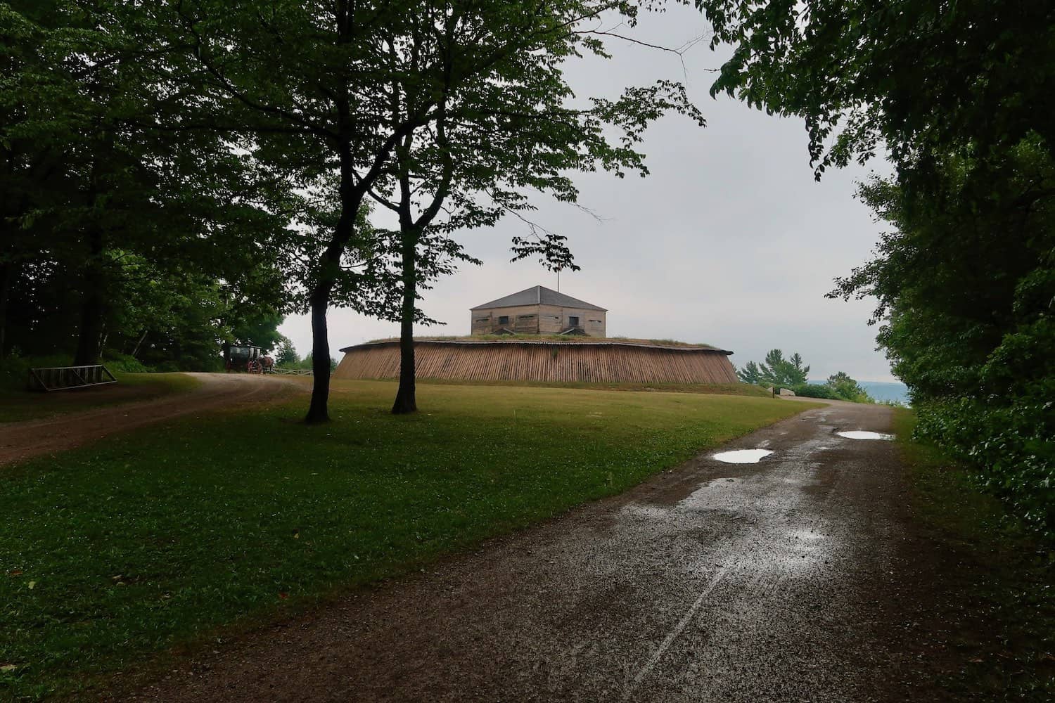
We opted for the stairs, which although unusually wet and mossy, soon brought us into view of the fort at the highest point on Mackinac Island.
Reconstructed Fort Holmes at Mackinac Island’s Summit

The last time I had been to Fort Holmes had been my second summer living on Mackinac Island, nearly eight years before. At that time, the fort was more of an abandoned curiosity on the island more than it was a tourist attraction. In this abandoned state, the remains of Fort Holmes consisted of only the round earthwork base and the wooden archway through it into the center.
It was also one of the (many) locations that seasonal island employees would gather for late-night drinking. While that may still be the case nearby the reconstructed fort, Jason and I did not find any day drinkers as we approached Fort Holmes.

Instead, the circular earthwork was populated with a solid wall of shaved timber logs, forming a ring around the inner blockhouse fort. It was certainly a different view than I remembered from my previous visit to the island’s summit.
The main (and only) gate of the fort faced southward, leading in the direction of a sheer cliff now replenished with trees after being stripped bare two centuries before. A bridge over the ditch surrounding the outer wall led into the fort. Inside the gate was a cleared courtyard surrounding the central blockhouse.

The courtyard itself is worth a walk around just to admire the care given in the reconstruction. Speaking as a frequenter of historical sites, many of which have undergone some level of reconstruction effort, the care given in the reconstruction of Fort Holmes is superb. The preservers did not highly disrupt the earthen fortification but instead made an accurate representation protecting it.

Inside the outer fortifications is the blockhouse itself, which is much more accessible than in the days the British defended it. Inside are informational plaques describing the entire history through the modern day, much of which has been related to you above.
Unfortunately, the second level of the blockhouse is not accessible to visitors. Only the ground level has an open area with informational displays on the walls. Two other groups had arrived since Jason and I entered the fort. After viewing the interior, Jason and I returned to the courtyard and then the southern cliff over the Straits of Mackinac to admire the view in the cold drizzle.

Although the day was gray and exceptionally windy, there was still a fantastic view to be had from the edge of the Fort Holmes clearing. This was, perhaps the best part of the experience. I’ve long held that the Straits of Mackinac is one of my favourite places I’ve ever travelled.
While this is probably nostalgia figuring in, I still believe the view of the Straits, be it from St. Ignace, Mackinac Island, or Mackinaw City is one of my favorites to see again and again.
How to Get to Mackinac Island’s Fort Holmes
GPS Coordinates: 45.85809, -84.61629

Fort Holmes Can be reached by walking, biking, or even Mackinac Island’s iconic horse taxis from anywhere on the island.
The starting point for most visitors to Fort Holmes will be the Main Street of Mackinac Island, where the majority of hotels and boat docks are located. On the east end of Main Street is Marquette Park, which sits under the imposing stature of Fort Mackinac.
A road named Fort Street runs along the western edge of the park, leading up to a trail that scales the hill behind Fort Mackinac. Nearing the top of this hill, the historic Governor’s Mansion comes into view at the intersection of Fort Street and Huron Street. Turning right onto
Fast Facts
Fast Facts
Name: Fort Holmes (formerly Fort George)
Where: Mackinac Island, Michigan, United States
Location: 45.85809, -84.61629
Description: Fort Holmes is a redoubt blockhouse fort located at the highest point of Mackinac Island and meant to support Fort Mackinac.
Getting there: Fort Holmes can be walked or cycled to from anywhere on the island or reached by horse taxi ($24 + tip).
Cost: Free
Glossary
British Landing
The northern point of Mackinac Island from which the British launched their attack to take Fort Mackinac during the War of 1812.
Fort Holmes
Fort Holmes is a redoubt blockhouse fort located at the highest point of Mackinac Island and meant to support Fort Mackinac.
Fort Mackinac
British Fort (later American) on Mackinac Island which fortified the Straits of Mackinac.
Fort Michilimackinac
British fort (originally French) in Mackinaw City used as a trading post and commercial center in the upper Great Lakes. Later moved to Fort Mackinac for better defense.
Mackinac Island
Historic island in the Great Lakes which is not a state park and tourist destination.
Mackinaw City
The town at the northern tip of Michigan’s Lower Peninsula.
redoubt
Outer fortification meant to support a larger fort.
St. Ignace
Town in Michigan on the southern tip of the Upper Peninsula.
Straits of Mackinac
Historically significant and narrow waterway where Lake Michigan and Lake Huron meet.
War of 1812
A conflict between the United States and the British Empire from 1812-1815
Sources
- “Blockhouses: Castles of the Frontier.” YouTube, Atun-Shei Films, 17 June 2019, www.youtube.com/watch?v=RVWpgjo6Q8g.
- “Fort Holmes (1).” Fort Holmes (1) – FortWiki Historic U.S. and Canadian Forts, www.fortwiki.com/Fort_Holmes_(1).
- “Fort Holmes Restored | Pure Michigan.” YouTube, Pure Michigan, 26 Aug. 2015, www.youtube.com/watch?v=PNNWVPhjJnY.
- “Fort Holmes.” YouTube, Mackinac State Historic Parks, 3 Aug. 2018, www.youtube.com/watch?v=z-xW8-01To8.
- gellison@mlive.com, Garret Ellison |. “Historic War of 1812 Redoubt Fort Holmes Rebuilt atop Mackinac Island.” Mlive, 17 Aug. 2015, www.mlive.com/news/grand-rapids/2015/08/fort_holmes_mackinac_island.html.
- “Mackinac Island.” Wikipedia, Wikimedia Foundation, 11 Sept. 2020, en.wikipedia.org/wiki/Mackinac_Island.
- Plominski, Tyler. “Fort Holmes.” Military History of the Upper Great Lakes, 12 Oct. 2015, ss.sites.mtu.edu/mhugl/2015/10/11/fort-holmes/.
- “Taxi Service.” Horse Drawn Taxi Service from Mackinac Island Carriage Tours, www.mict.com/taxi-service.html.
- Thwaites, R. G. “AN OUTLINE OF MACKINAC HISTORY.” Bulletin of the American Library Association, vol. 4, no. 3, 1910, pp. 522–524. JSTOR, www.jstor.org/stable/25684900. Accessed 13 Nov. 2020.


This is fantastic! Love the history! Inspiration for a possible illustrated map. Good work!
Interesting. What sort of illustrated map do you mean?
Its a crazy looking structure!
Block houses in general are pretty interesting and varied in their styles. I haven’t seen any other example of this kind of diagonal block house though.