Archaeological travel guide and brief history to the best-preserved city walls and fortifications from ancient Thailand.

Ancient city walls have always been one of the most interesting architectural features in history to me. They represent not only a means of protection, but a monumental engineering and architectural feature that scales to whatever population it protects.
Numerous ancient cities in Thailand were protected by city walls. They began around 2000 years ago and continued well into the modern period in the 1900s. The city walls in Thailand began as earthen fortifications and ended as brick walls around cities like Ayutthaya and Bangkok.
This article presents some of the best and most complete examples of ancient fortifications from Thailand over the last 2000 years. You’ll learn the basic history of the fortifications, details of the cities and their walls, and information about visiting for yourself.
A Brief History of Ancient Thailand’s Fortifications
Thailand has a long history of fortifications dating back to even before the region’s recorded history. One of the country’s oldest semi-urban archaeological sites and UNESCO World Heritage Site Ban Chiang (c. 1000 BCE), while not boasting evident fortifications, does have evidence of artificial earthworks purpose-built to level the landscape above the lower rice fields in the surrounding landscape.
The next 1000 years saw these same earthworking and irrigation methods used to fortify small settlements throughout the Central Plains and Isaan Plateau.
Ancient city walls in Thailand generally fall into one of three types (or a combination of them) – earthen walls, stone/laterite, or brick.
Earthen walls
Small cities with earthen walls (occasionally supplemented with wooden palisades) were the norm for most of the last 2000 years in Thailand. Often built in a circular shape and surrounded by a moat, these were the earliest fortified cities in the region. As the Indianized Dvaravati culture began spreading from the Myanmar border throughout Thailand, they inhabited and occasionally expanded these settlements. Later Khmer and Tai migrations used these same fortifications in their early history (often due to inhabiting earlier Dvaravati cities).
The best examples of earthen walls can be seen at Sukhothai, Muang Sema, Chiang Mai, and Si Thep.
Stone or laterite walls
As an abundant building material, stone has been used in fortifications all over the world. Usually bound together with a locally produced mortar, it produces a strong material for fortifications or just general buildings. A related method is used often in Southeast Asia with laterite, a naturally occurring clay that hardens in air into a porous stone-like material, this is often shaped into blocks or bricks and used for buildings.
The best examples of laterite walls can be seen at Muang Sing, Kamphaeng Phet, Si Satchanalai, and Phimai. One of the best examples of mortared stone fortifications in Thailand is seen along the northeast wall of Lopburi.
Brick walls
Bricks were a relative latecomer to ancient Thai fortifications, although they make an earlier appearance in Dvaravati and Khmer temples in the region. Brick walls were often placed above earthen fortifications or incorporated into the design (either as fill in the middle or as a support in the back).
It needs to be noted that bricks are a lot harder to produce and use for several reasons–
- they rely on whatever local material they are made of to be solid (e.g, mud-baked bricks don’t require much heat at all)
- They require a furnace and/or method hot enough to bake them reliably
- They are much smaller individual building units than other construction methods
- They most often require a good mortar to maintain stability
Brick walls continued to be the norm through the early modern period, particularly in prominent cities like Rattanakosin, Lopburi, Chiang Mai, and Nakhon Ratchasima.
Honorable Mention: Bangkok (Rattanakosin)

While not ancient by any strict definition, Bangkok was a walled island city during its early history in the 1800s CE. During this time, The Rattanakosin (and Thonburi) walls were built of bricks covered with a white stucco plaster that can still be seen in some locations around Rattanakosin island.
10) Wiang Kalong | Chiang Rai, Thailand
GPS Coordinates: 19.20437, 99.54035

Wiang Kalong is an unusual example of a fortified hilltop city in Thailand, something not common in Southeast Asia. The area was also known for a unique style of pottery in northern Thailand and many of the ancient kilns can still be seen in the lower areas around the hill city.
“Wiang” in the local dialect refers to a walled or fortified settlement. The walls of Wiang Kalong are all earthen mounds with large ditches between them. The oldest area is a circular citadel near the southern end. There is evidence of periods where the city’s walls were expanded, most notably a long area approximately 1.2 km (.75 miles) to the north.
Today, Wiang Kalong is preserved as a park with an onsite museum. A road goes up the hillside about 2km (1.25 miles) east of Road 118, the main route from Chiang Mai to Chiang Rai. From the museum and main parking area, visitors can take paths through the ancient city’s fortifications and to a newly built temple, Wat Phra Yod Khun Phon, which provides a wonderful view over the valley below.
9) Phrae | Phrae, Thailand
GPS Coordinates: 18.14332, 100.13833

The city of Phrae is a small provincial capital with a long history dating back nearly 1000 years. Throughout its history, the city has been part of several kingdoms with periods of independence. The region was known for its teakwood industry and many homes in the Old City today are made in a traditional teak style.
The earthen city walls were built along the Yom River in the traditional auspicious shape of a conch shell (like other pre-Thai northern cities Lamphun and Lampang). With the exception of a few spots where modern roads cut through, almost the entire length of the wall remains and is often accessible by stairs and walkways to the top.
The ancient city of Phrae today is a modern town located both inside and outside the ancient fortifications. While there is a small local museum located at Wat Luang inside the city wall, it is not as thorough or organized as well as those run by Thailand’s Fine Arts Department.
8) Sukhothai | Sukhothai, Thailand
GPS Coordinates: 17.01763, 99.70375

Main article: Sukhothai: Dawn of Happiness, Dawn of Thailand
One of the most famous ancient cities in Thailand, Sukhothai is often called the “First Capital of Thailand”. While this is not quite historically accurate, the city did play an immensely significant role in the history of the Thailand kingdom. Previously an Angkorian settlement in the Khmer Empire’s far northwestern territory, Sukhothai was among the first to be overthrown and replaced with an independent Thai kingdom.
The city fortifications of Sukhothai are made up of three rows of earthen walls in a square shape. Unlike its sister cities at Si Satchanalai and Kamphaeng Phet, there is no indication of later stone or brick renovations to the walls, although there are remnants of laterite structures at the city gates. Despite its age, popularity, and the fact that a major road was previously built through the fortification, the walls are still in remarkable condition. Even the secure structure of the city gates is easy to discern.
Today, the Sukhothai Historical Park is a UNESCO World Heritage Site along with the related cities of Si Satchanalai and Kamphaeng Phet. Inside the city walls, a modern residential town with modest tourist facilities exists in the eastern third while the western two-thirds are designated as protected historical sites.
7) Phimai | Nakhon Ratchasima, Thailand
GPS Coordinates: 15.21884, 102.49468

Phimai is a Khmer city referred to as far back as the pre-Angkorian Chenla Period, nearly 1400 years ago. The fortified city of Phimai seen today began primarily during the reign of Jayavarman VII (c. 1181-1220 CE), it was oriented in the direction of the Khmer capital at Angkor. The city served as the endpoint of the Dharmasala Route, a royal road lined with rest houses called Dharmasalas.
As one of only two walled cities built by the Khmer in modern Thailand, Phimai was fortified by a rectangular laterite wall. Although most of the laterite wall has been dismantled and is now missing, there are still spots where it remains intact at the west gate, north gate, and most notably the south gate pointed at Angkor. The outline of the city wall can easily be seen along the moats on the ground or in satellite images.
Phimai today is a residential town almost entirely contained within the ancient city wall. A historical park is set up in the town center where the main Anngkorian temple, Prasat Hin Phimai, is located and underwent significant restoration in the 20th Century. Several smaller ruins are also in the area and are open to the public, easily accessible by bike from the city center.
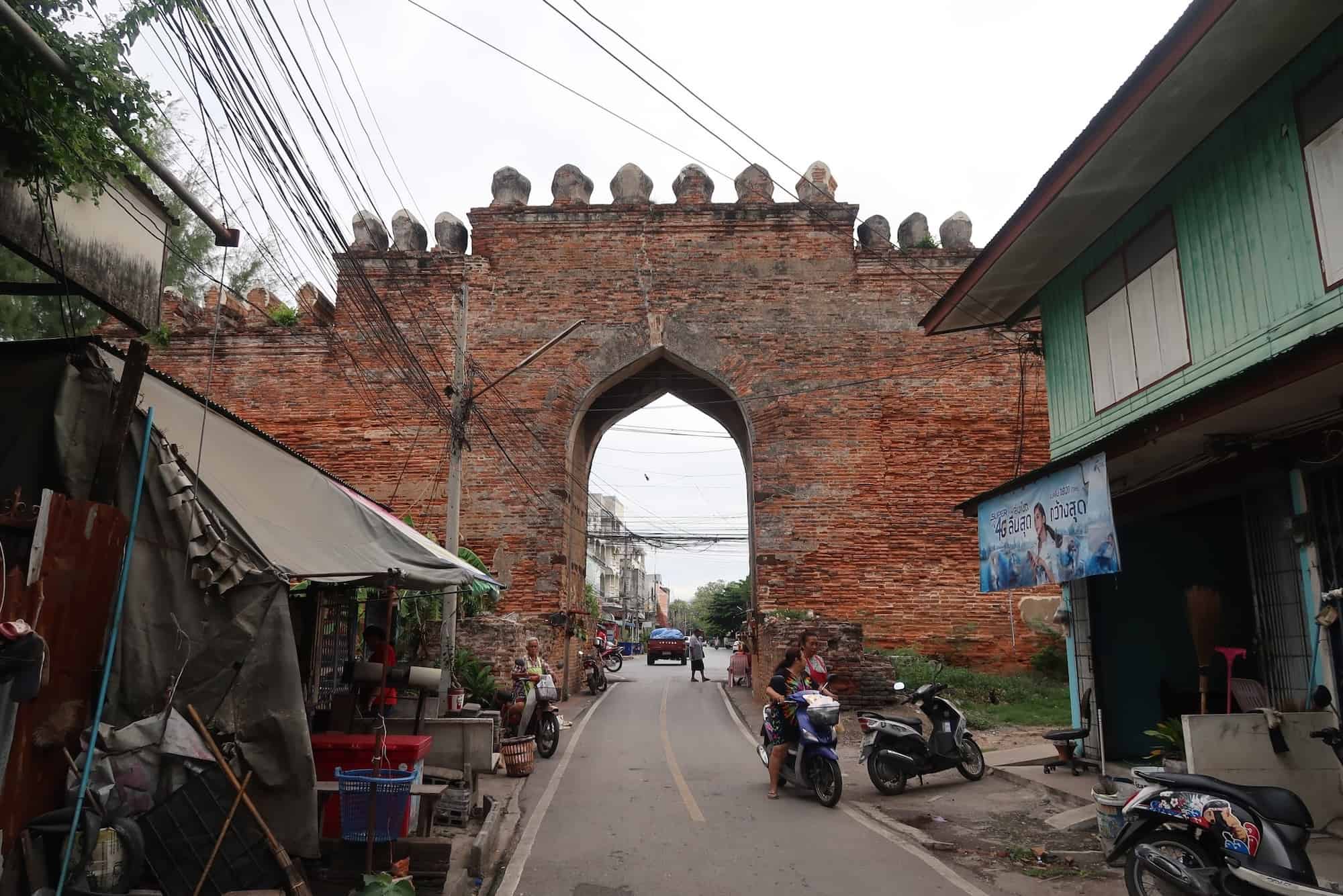
6) Chiang Mai | Chiang Mai, Thailand
GPS Coordinates: 18.7883, 98.98543

Chiang Mai was the center of the Thai Lanna Kingdom, a distinct political entity from either Sukhothai or Ayutthaya (the kingdom that would eventually become Thailand) for most of its history. Prior to settlement by the Lanna Thais, the area was controlled by the Dvaravati offshoot Hariphunchai Kingdom and home to several walled cities built by the indigenous Lawa people.
Today, there are sections of five separate city walls that can be seen in the city of Chiang Mai, with the least authentic of these curiously being the actual city wall of Chiang Mai. The five gates visible around the Chiang Mai Old City are all entirely reconstructions, and not all that accurate. The forts at the corners are a bit more authentic, but also largely the result of restorations with an original stretch of wall running east from the northeast Hua Lin Fort.

To the south and east of the Old City is the outer city wall, Kamphaeng Din (“earthen wall”), a later extension added to the main city that can still be seen along several sections, particularly on Kamphaeng Din Road. Even further southeast is Chiang Mai’s predecessor city of Wiang Kum Kam, which also had an earthen wall, although only very faint traces of them remain.

To the west of the old city are the walled Lawa cities of Wiang Chet Lin and Wiang Suan Dok. Predating Chiang Mai by centuries, these cities had earthen walls that are still largely visible. The square wall of Wiang Suan Dok can be seen on Suthep Road and explored more behind the Chiang Mai University building north of the road. The circular wall of Wiang Chet Lin can be seen from Huay Kaew Road just before the Chiang Mai Zoo and explored further on the streets to the north.
5) Lopburi | Lopburi, Thailand
GPS Coordinates: 14.79862, 100.61389

Main article: Ancient Lopburi: Lost Cities Travel Guide
The Central Plains city of Lopburi has been continuously inhabited through several important historical periods, including the Dvaravati, Khmer, and Ayutthaya Periods. Through all of these, the initial Dvaravati settlement served as the centerpiece, although only a single Dvaravati monument remains today at Wat Nakhon Kosa.
The fortifications at Lopburi represent several periods of expansion during the Ayutthaya Period (c. 1300-1700 CE). These primarily brick fortifications can be seen in two main areas: along the eastern and southern moats. Toward the north of the eastern moat are several stretches of high preserved wall and the Tha Pho Fort staging alone overlooking the river. A well-preserved city gate at the southern tip of the Lopburi Old City is also surrounded by stretches of intact city wall.
Additionally, there are city wall remnants further to the east along one of the moats built during a period of expansion. However, these are located on a military base and are not open to the public.
Lopburi is easily accessible from Bangkok by train, bus, or shared van. Most of the historic sites (Khmer, Thai, and Dvaravati) are located within the walkable Old City area along with a number of hotels and restaurants.
4) Chiang Saen | Chiang Rai, Thailand
GPS Coordinates: 20.27418, 100.08706

Chiang Saen in the far north of Thailand is one of the several predecessor cities to Chiang Mai as the proto-Lanna Kingdom moved south, largely in response to the encroaching Mongol Empire/Yuan Dynasty. It also has a legitimate claim to being the oldest city in Thailand (depending on definition). Despite this, the ancient city seen today mostly dates from its time as part of the Lanna Kingdom rather than this earlier period.
The ancient city walls and monuments of Chiang Saen were built in the 14th Century CE. The mostly intact wall and moat run along an irregularly-shaped perimeter on the sides not facing the Mekong River. Originally built in a stepped manner that allowed troops easy access to the upper levels and brick forts spaced along important defensive areas, the wall underwent a modern restoration resulting in its current appearance.
Today, Chiang Saen is easily accessible by bus from the provincial capital, Chiang Rai, and is only a short distance from the popular tourist spots of the Golden Triangle. Like Lopburi and Chiang Mai, the majority of ancient temples are located within the modern city and can be visited by bike, motorcycle, car, or even walking. There are also a good number of lodging options available in the area, mostly located along the Mekong River.
3) Si Satchalanai | Sukhothai, Thailand
GPS Coordinates: 17.43218, 99.78657

The history of Si Satchanalai is inextricably linked to Sukhothai, both having been Khmer outposts that were succeeded as Thai city-states around the same time. While neither as large or influential as its sister city, Si Satchanalai continued as an important cultural center through the Sukhothai and Ayutthaya Periods, including hosting one of the largest Ayutthaya-style prangs in the country.
Unlike Sukhothai, which has a roughly square plan, the city fortifications of Si Satchanalai are built to embrace the natural topography. Utilizing the Yom River and two mountains in the north of the city, the city has an irregular shape, with its walls built along these natural features. In addition to the original earthen walls, Si Satchanalai was reinforced with laterite walls and gates.
Today, Si Satchanalai is relatively remote to the point where you’ll need private transportation to get there and explore the area. The nearest town, Hat Siao, is about 13 km (8 miles) away and there is no transportation from there to the Si Satchanalai Historical Park, but there are also tour companies in Sukhothai that will take you there for a day trip. The entire ancient city is protected as a historical park, with a few outlier temples in the landscape outside the walled city.
2) Kamphaeng Phet | Kamphaeng Phet, Thailand
GPS Coordinates: 16.48965, 99.51648

Main article: Kamphaeng Phet and the Aranyik Forest Temples
Kamphaeng Phet, like many other of Thailand’s ancient cities, began as a Dvaravati settlement – or more accurately a series of them. There are at least 5 ancient moated settlements in the immediate area of modern Kamphaeng Phet (including the walled city of Kamphaeng Phet). Following the Dvaravati Period, the city was inhabited by the Sukhothai and Ayutthaya Kingdoms. While the region was also controlled by the Khmer Empire prior to the Sukhothai Period, there is no direct evidence of Angkorian architecture in the city.
Its naming meaning “Diamond Wall”, the ancient fortifications of Kamphaeng Phet are both a unique shape and one of the most complete in the country. The city was originally protected by the moat and three successive walls, the outermost of which was reinforced with a laterite fortification.
Today, the inner earthen walls are not as evident, but the walls and forts made of laterite are almost entirely intact along the city moat. In addition to the historical park, inside the city wall is also a university, a military base, and a residential area. However, there is no easily accessible way for a visitor to get around. Arriving with your own transportation is preferable, especially if you plan to see the outer Aranyik or Nakhon Chum ruins
1) Muang Sing | Kanchanaburi, Thailand
GPS Coordinates: 14.0393, 99.24298

Main article: Prasat Muang Sing: Angkor’s Last Outpost
Muang Sing is an Angkorian city on the farthest western frontiers of the Khmer Empire. Built in the 11th Century CE on the same location as an older city from the Dvaravati Period (an even older prehistoric settlement), Muang Sing contains the ruins of 4 Khmer temples. The most intact of these, Monument 1, is built in the Bayon style and was devoted to the worship of Avalokiteshvara, a central figure in Mahayana Buddhism.
The laterite city walls of Muang Sing are the most intact and complete ancient fortifications in Thailand, still running the entire perimeter of the thousand-year-old city. Straying slightly from the usual square-rectangular city plan of the Khmers, the southern wall projects out to parallel a sharp bend in the Khwae Noi River. Four city gates are interspersed throughout the wall.
The site today is preserved by Thailand’s Fine Arts Department as a historical park. A small visitor center also serves as the site museum with a selection of artifacts on display from the Khmer period. A short 120m (400 feet) walk from the visitor center are Monuments 1 and 2, the main ruins inside the park. Scattered inside the walls are smaller ruined foundations, ancient reservoirs, and a small local village that existed in the area before the establishment of the historical park.
Glossary
Aranyavasi
A forest-dwelling sect in Thai Theravada Buddhism who are removed from the distractions of city life in order to better contemplate the Buddhist teachings.
Avalokiteshvara
A future compassionate Buddha incarnation meant to usher in enlightenment followers of the Mahayana Buddhist sect
Ayutthaya
City in central Thailand and historic capital of the Ayutthaya Kingdom, which was succeeded by the Thonburi Kingdom in 1767.
Ayutthaya Kingdom
Thai kingdom based in central Thailand, later referred to as Siam. Its capital was the city of Ayutthaya until the city was destroyed by the Burmese, forcing the state of Siam to relocate to modern Bangkok and found the Thonburi Kingdom in 1767.
Bayon style
Khmer architectural style lasting from 1180-1230 and characterized by laterite construction, less intricate carvings, and Buddhist themes.
Buddhism
Dharmic religion centered on the belief of karma and release from the cycle of reincarnation. Based on the teachings of Siddhartha Gautama.
Chiang Mai
City in northern Thailand and historic capital of the Lanna Kingdom founded by King Mangrai in 1296.
Chiang Rai
City in northern Thailand founded by the Lanna king Mangrai in 1262 CE.
Chiang Saen
City in northern Thailand and historic capital of the Ngoenyang Kingdom until the establishment of its successor, the Lanna Kingdom, in 1293 CE.
dharmasala
“Fire house” temple design built along the Khmer Empire’s Angkor-Phimai road by Jayavarman VII.
Dharmasala Route
Important road from Angkor to Phimai and lined with 17 dharmasalas.
Dvaravati
Mon-Burmese ethnic group based in modern Nakhon Pathom, Thailand. Responsible for the introduction of Buddhism (Theravada sect) to Thailand.
Hariphunchai
Ancient name of Lamphun, Thailand and the historic capital of the Dvaravati Hariphunchai Kingdom.
Hariphunchai Kingdom
Dvaravati kingdom in northern Thailand (c. 750 – 1292 CE) centered in the modern town of Lamphun. Eventually conquered by the Lanna Kingdom.
Indianization
A culture adopting Indian culture, religion, and social structures.
Isaan
Common name for the northeastern region of Thailand.
Jayavarman VII
Mahayana Buddhist king of the Khmer Empire from 1181–1218 who conquered Champa, built Angkor Thom, and initiated massive engineering projects to rebuild the kingdom.
Kamphaeng Phet
City in Central Thailand and historically part of the Sukhothai Kingdom.
Khmer
Austroasiatic ethnic group native to Southeast Asia and the majority inhabitants of the modern nation of Cambodia.
Khmer Empire
Hindu-Buddhist kingdom which ruled much of Southeast Asia from their capital at Angkor.
Lampang
City in northern Thailand historically known as Khelang Nakhon. Founded by the Hariphunchai Kingdom to control the Wang River Basin, the city was later absorbed by the Lanna Kingdom.
Lamphun
City in northern Thailand and the historic capital of the Hariphunchai Kingdom.
Lanna Kingdom
Thai kingdom based in northern Thailand and northwestern Laos. Its capitals included Chiang Rai, Wiang Kum Kam, and Chiang Mai.
laterite
Red clay-like soil which hardens when dry and is used in many types of construction.
Lavo Kingdom
Dvaravati kingdom in central Thailand centered in the modern town of Lopburi. Eventually conquered by the Khmer Empire.
Lawa
Ethnic minority group who constructed three walled cities in the Chiang Mai valley: Wiang Nopburi, Wiang Ched Lin, and Wiang Suan Dok. They are also referenced in historic writings as Lua, Milukku, Tamilla, and La.
Mahayana Buddhism
A sect of Buddhism focused on the reverence of bodhisattvas.
Mangrai
Final ruler of the Ngoenyang Kingdom (Chiang Saen) and founder of the Lanna Kingdom from 1291-1311 who established Wiang Kum Kam in 1286 and its successor Chiang Mai in 1293.
Mekong River
The world’s 12th longest river, which flows from the Himalayas through China, Myanmar, Laos, Thailand, Cambodia, and Vetnam, into the Pacific Ocean.
Mongol Empire
The largest contiguous empire in human history founded by the conquests of Genghis Khan in 1206. By its end in 1294, the Mongol Empire had broken into 4 political entities: the Yuan dynasty, the Chagatai Khanate, the Ilkhanate, and the Golden Horde.
Phimai
Walled city of the Khmer Empire dating back to at least the 600s CE. The city stood at the end of the important Angkorian Dhammasala Route.
rammed earth
A construction technique of compacting and compressing dirt into solid walls, floors, and building foundations.
Rattanakosin Kingdom
Thai kingdom and successor to the Thonburi Kingdom. Based in Bangkok and founded in 1782, the Rattanakosin era lasted until 1932, when political reforms transformed the kingdom into the modern nation of Thailand.
prang
A Khmer Hindu tower representing Mount Meru and taking the formlotus bud. Thai architecture later adopted the design into their Buddhist temples.
stupa
Buddhist monument used to enshrine sacred relics or memorialize important figures. Its dome, bell, or otherwise tower-like appearance is an architectural representation of Mount Meru, the cosmic mountain said to represent the structure of the universe in Hindu-Buddhist cosmology.
Si Thep
Dvaravati city in Phetchabun Province that was later occupied by the Khmer Empire.
Sukhothai
City in central-northern Thailand and abandoned capital of the Sukhothai Kingdom.
Sukhothai Kingdom
Thai kingdom based in central-northern Thailand, after the overthrow of Khmer rules. Its capital was the city of Sukhothai, which was later conquered and absorbed by the Ayutthaya Empire.
Tai peoples
Ethnic group originating in Southern China that migrated south during the Mongol invasions, eventually founding the kingdoms hat became Thailand and Laos.
Theravada Buddhism
“The “Doctrine of the Elders” branch of Buddhism which draws its teachings from the Pali Canon. This sect is popular in Sri Lanka, Myanmar, Laos, Cambodia, and Thailand. Also known as Hinayana Buddhism or “The Lesser Vehicle”.
Theravada Buddhism
“The “Doctrine of the Elders” branch of Buddhism which draws its teachings from the Pali Canon. This sect is popular in Sri Lanka, Myanmar, Laos, Cambodia, and Thailand. Also known as Hinayana Buddhism or “The Lesser Vehicle”.
Thonburi Kingdom
The historic successor of the Ayutthaya Kingdom founded in 1767 in modern Bangkok. It was succeeded by the Rattanakosin Kingdom in 1782.
wiang
Lanna Thai word for “walled city”
Wiang Chet Lin
Fortification built by Lanna King Sam Fangkaen over the ruins of Wiang Misankorn.
Wiang Kum Kam
The first city established by the Lanna Kingdom in the Chiang Mai valley. Abandoned after successive years of flooding to establish Chiang Mai.
Wiang Suan Dok
Abandoned Lawa walled city used by Lanna royalty as a garden. In 1371, Wat Suan Dok was established in the center of Wiang Suan Dok.


