A complete archaeological travel guide to the ruins and historical sites of Wiang Kum Kam, the first capital of the Lanna Kingdom that was abandoned and buried beneath the Ping River.

Chiang Mai has long been a major tourist attraction within the modern nation of Thailand. However, its history goes back many centuries before it was ever a part of Thailand, and was instead the capital of the Lanna Kingdom.
Following the conquest of Hariphunchai (modern Lamphun) by the Lanna Thais led by King Mangrai, the new ruler of northern Thailand was seeking a capital for this fledgling kingdom. During his slow march south from Chiang Saen, Mangrai had already establish two other ephemeral capitals in Chiang Rai and Fang. Rather than settling in the former Hariphunchai capital, Mangrai chose instead to build another new city in the form of Wiang Kum Kam.
Wiang Kum Kam was a satellite city of Hariphunchai that was renovated into the new Lanna capital in 1286 CE. Numerous improvements were built in the form of walls, irrigation, and dozens of temples throughout the city. However, after only 5 years in Wiang Kum Kam, the Lanna King Mangrai abandoned the city due to flooding in order to build his final capital at Chiang Mai.
This is the story of the rise and fall of Wiang Kum Kam — from its beginnings under the Dvaravati kingdom of Hariphunchai to rise as a Lanna capital and finally its abandonment due to natural disasters. This article will guide you through the city, each of its historical monuments, and provide all the information you’ll need to visit for yourself.
Contents
The Story of Wiang Kum Kam
The history of Wiang Kum Kam spans 5 major eras, all of which will be covered here. Those are:
- Wiang Kum Kam’s time as a defensive satellite city of Hariphunchai
- The 5-6 years Wiang Kum Kam served in an early role as the capital of the Lanna Kingdom before being abandoned because of flooding
- The 100+ years after Mangrai moved the capital to Chiang Mai as it was a nearby town of Chiang Mai and dealt with regular flooding
- The 200+ years between Wiang Kum Kam’s final abandonment and complete disappearance from history during the Burmese occupation of Lanna
- The modern era of development and rediscovery as Lanna descendants uncovered their forgotten capital city
Wiang Kum Kam in the Hariphunchai Period
Main article: Ancient Lamphun: The Enduring Kingdom of Hariphunchai

For many centuries before the arrival of the Thais under Mangrai, Northern Thailand was controlled by the Hariphunchai Kingdom. This Mon kingdom was the last remaining of the ancient Dvaravati Kingdoms that had proliferated throughout Thailand during the 1st Millennium CE.
While the rest of the Dvaravati city-states were overtaken by the rapidly expanding Khmer Empire, Hariphunchai (modern Lamphun) maintained its independence and continued to flourish into the early 2nd Millennium CE.
As part of its defensive strategy, Hariphunchai employed a network of satellite cities around its capital, as well as around other important cities like Lampang. Wiang Kum Kam was originally one of these satellite cities located north of Hariphunchai. The remnants of other satellite wiangs (“fortified towns”) can be seen nearby in the remains of Wiang Tha Kan and Wiang Mano.
And while Wiang Kum Kam was an active city as far back as the Hariphunchai Period, most traces of the era was lost to the subsequent centuries of rebuilding, flooding, abandonment, and rebuilding again. However, some small relics from Hariphunchai have been found, such as pottery fragments, Buddhist votive tablets, and even a few early bases of temples built over by the later Lanna rulers.
The Arrival of the Thais
Main article: Cultural Profile: Lanna Kingdom, Heirs of Northern Thailand
The 13th Century ushered in sweeping changes over the political landscape of Asia, sparked on in no small part by the rapid expansion of Genghis Khan and the Mongol Empire. This empire that had swept through China became an existential threat to the longstanding regional powers in Southeast Asia, exacting tribute from the weakened Khmer Empire, while simultaneously upending states that opposed them, including the Nanzhao and Pagan Empires.
One indirect result of this political upheaval was the migration of Tai peoples out of Southern China into the area of modern Thailand. This included a group led by the Mangrai, the heir of the Ngoenyang Kingdom (precursor to the Lanna Kingdom) in modern Chiang Saen. After taking the throne in 1259 CE, Mangrai began a decades-long campaign to expand and fortify his kingdom.
This resulted in the founding of several cities, such as Chiang Rai (1262) and Fang (1272) in the Kok River Valley, before setting his sights on Ping River Valley and Hariphunchai. Following his military campaigns from Fang and conquest of the Hariphunchai Kingdom in 1283, Mangrai resided in Hariphunchai (modern Lamphun) for 3 years before opting to establish the capital of his new Lanna Kingdom at Wiang Kum Kam in 1286 CE.

There were several reasons Mangrai made this move to Wiang Kum Kam rather than remaining in the established city of Hariphunchai. Chief among them was the long history of Hariphunchai, which had played an important role as the cultural and religious center of the region for centuries. While Mangrai carried on many of the longstanding traditions of Hariphunchai’s art, architecture, and Theravada Buddhist religion, he chose to leave Hariphunchai as a cultural center rather than a political center.
The Ping River which goes through the heart of Chiang Mai does not flow through Lamphun today, however, it did during the early days of the Lanna Kingdom. Wiang Kum Kam, built along the ancient course of the Ping River, was located only a small way upstream. This provided proximity to Hariphunchai, convenient access to transit and trade routes, and room to expand for the ambitious, young kingdom.
Leaving Wiang Kum Kam and the Founding of Chiang Mai

The status of Wiang Kum Kam as the Lanna capital was to be short-lived. After Mangrai moved to the city and lived there for 5 years, the geography of the city soon proved disadvantageous for developing a thriving city.
The historic city of Wiang Kum Kam is located on low-lying land that is quickly overrun by flooding during the rainy season. Even today, much of the area is exceptionally swampy, even out of the rainy season. Throughout the wettest parts of the year, many ruined temples are surrounded by large pools of water.
This problem of geography led Mangrai to once again search for a new capital. Rather than returning downstream to Hariphunchai, Mangrai looked to the base of Doi Suthep, a mountain that had been a sacred spot to both Hariphunchai and the preceding Lawa cities of the Ping River Valley. It was here that Mangrai would found his final capital, the city of Wiang Nopburi Si Nakhon Ping Chiang Mai — more commonly known as Chiang Mai (“New City”).
As a core city in the heart of the Lanna Kingdom, Wiang Kum Kam continued to play an important role through the 14th and 15th Centuries CE. despite the persistent flooding. Many temples in Wiang Kum Kam continued to receive renovations and royal patronage even after Chiang Mai was established. Aside from the ruins of many intricate temples, some of which are still active today, there is evidence of irrigation canals and a bridge over the Ping River during this era.
Wiang Kum Kam also remained important as a fortified outpost on the southern end of Chiang Mai city, much as it had been for Hariphunchai before the Thais had arrived. The city’s name appears from inscriptions during King Kuena’s reign (1355–1385) found in Wat Phra Yuen in Lamphun.
Archaeological and Geological Studies on the Destruction of Wiang Kum Kam

There are earthen dikes located along the northern bank of the former Ping River’s course that have been demonstrated as artificial constructs, and likely the barriers that served as the base of Wiang Kum Kam’s northern city wall. These mounds/dikes have been dated to the first 20 years of the 1400s CE.
Excavations done in 1987, 2010, and 2011, sediment studies took place on these mounds along the former northern riverbank, in the ancestral riverbed of the old course of the Ping River, and at Wat E Kang, one of the city’s ruined temples. The evidence they found led the archaeologists to conclude that, while flooding continued to be a regular occurrence throughout the 1300-1400s CE, the city continued to thrive during these centuries.
However, these same studies indicated that it was one major flooding event that deposited massive amounts of sediment over the city. This was most likely to be the singular cause for both the Wiang Kum Kam’s final abandonment and for changing the course of the Ping River, an event that moved Wiang Kum Kam from being on the west bank to its present location on the east bank of the Ping River.
Between the sediment studies and comparative art studies done during archaeological excavations, these researchers have placed the approximate dates for the abandonment of Wiang Kum Kam between 1527-1831 CE, which lines up with the conquest and occupation of Chiang Mai and Lanna by the Burmese.
There is a major natural disaster record as having taken place in Chiang Mai during 1524-5. In which storms and rising waters destroyed many of the temples within the heart of Chiang Mai city, including the massive Wat Chedi Luang. Considering Chiang Mai is 12 meters higher than Wiang Kum Kam and some distance inland from the riverbank, the damage done to the lowland Wiang Kum Kam built right on the riverbank must have been massive.
The researchers who conducted these studies in 2010 and 2011 have concluded that this was the likely event that caused Wiang Kum Kam to finally be abandoned.
Abandoned and Forgotten During Burmese Occupation

By the late 1500s CE, the Lanna Kingdom had weakened from both internal political instability and decades of border conflicts with the Ayutthaya Kingdom in the south. This allowed the Burmese Toungoo Empire to conquer Chiang Mai in 1558 and occupy it for another 200 years. During this period, the core cities of Lanna, including Chiang Mai and Lamphun, were forcibly depopulated. Without these cultural strongholds to maintain it, Wiang Kum Kam was finally abandoned entirely.
By the time Kawila was launching his military campaigns to retake Lanna territory in the late 1700s CE, the area of Wiang Kum Kam was known as Tha Wang Tan and there was no mention of its former name in any contemporary writings. It was from here that Kawila, in alliance with the Thonburi Kingdom (formerly Ayutthaya), launched the attack that would retake Chiang Mai city for the Thai people.
Resettlement and Rediscovery of Wiang Kum Kam
After the Burmese were expelled from Northern Thailand in the late 1700s and Chiang Mai began to be repopulated, outer areas of the city, including around Wiang Kum Kam were left alone or used primarily for agriculture. As Chaing Mai city continued to grow into the 20th Century, the area began changing from farmland to mostly residential suburban sprawl.
That is not to say some temples did not remain active. Living temples from earlier periods still exist at Wat Chedi Liam and Wat Khan Tom, although never structures have been built overtop the older monuments, with even Chedi Liam’s signature Hariphunchai-style stupa undergone extensive renovations.
Beginning in 1984, the Thailand Fine Arts Department, which is responsible for excavating and maintaining the country’s archaeological sites and museums, began archaeological surveys of the area around Wiang Kum Kam.
The first excavation to take place was at the aforementioned Wat Khan Tom, which stands on the grounds of an earlier temple named Wat Chang Kam. Here they discovered artifacts from both the early Lanna and Hariphunchai Periods, as well as the ruined foundations of the earlier temple. This discovery sparked the further exploration of the site and the excavation of 34 total monuments associated with the city of Wiang Kum Kam between 1984 and 2002. Most of these monuments were found on the former west bank on the Pink River and buried 1-2 meters below the modern ground level.
Art and Architecture of Wiang Kum Kam

While Wiang Kum Kam was originally a Hariphunchai settlement, most of their architecture was built over and subsequently replaced by the Lanna temples over the two centuries the city was occupied. Meanwhile, their artifacts, such as pottery, Buddhist votive tablets, and even a handful of Mon-language inscriptions were found and are now housed in local museums.
The Lanna Kingdom’s occupation of Wiang Kum Kam was also the first period in which they began incorporating Hariphunchai art styles into their own. The most obvious example of this is at Wat Chedi Liam, where the primary stupa is based on the square-based pyramidal stupas found in Lamphun, such as the Ku Kut Chedi. However, square stupa bases with redented corners (notched or indented) and prasat-style (brick tower) stupas were also drawn from the Mon-Dvaravati tradition in ancient Lamphun.
After seeing a handful of the main temples throughout Wiang Kum Kam, you’ll begin noticing a very common architectural style: a long narrow viharn (main worship hall) and a disconnected stupa at its rear. This same style can be found on all the early Lanna Buddhist temples dating back to their origins in Chiang Saen (as well as other ruined northern temple sites) and it continues to be the primary layout of Buddhist temples in northern Thailand to this day.
Where the architecture of Wiang Kum Kam differs from later Lanna architecture is the integration of Burmese styles, which were adopted during the 2centuries of occupation. While many of the most historic temples in Chiang Mai city have elements of Burmese art, none of the excavated temples at Wiang Kum Kam do.
Along with the early phase of Lanna architecture, excavations also uncovered a good number of artifacts — ranging from Lanna-period pottery (San Kamphaeng and Wiang Kalong kilns), continued use of Hariphunchai-style votive tablet, and even foreign artworks, including Khmer Buddha images from Lopburi and Ming Dynasty pottery.
Most of these items can be viewed today at the Wiang Kum Kam Information Center, located just south of the ancient walled city. Others are found at the Chiang Mai National Museum and the Hariphunchai National Museum in Lamphun.
Visiting Wiang Kum Kam

My initial visit to Wiang Kum Kam seemed like quite the excursion out of Chiang Mai at the time. In reality, I was only driving 6 km out of the Old City, along the scenic Chiangmai-Lamphun Road. Oddly enough, I’d end up living on that same road 3 years later.
This historic road is lined with hundreds of large trees wrapped in orange robes, the same bright color as those of Thailand’s revered Buddhist monks. From its northern origin in Chiang Mai, the road will take you to Pratu Chang Si, the northern city gate of Lamphun.
However, I wasn’t going quite that far, and a quick drive through the Nong Hoi Market and the intersection with the Mahidol Road overpass brought me to Wat Ku Khao, an imposing ruined stupa on the roadside that marked one of the three entrances to the ancient city of Wiang Kum Kam.
However, this was also the farthest entrance from the heart of the city and where most of the ruins were located, with a maze of residential streets in between. Even after driving through routinely for 3 years, I still get lost in this tangle of roads.
Wiang Kum Kam Atlas
The temple ruins of Wiang Kum Kam are laid out in an haphazard manner within a mainly residential area. While there are a core of primary temples that most guide will recommend, there are others further out of this core that are also worth seeing.
All official documentation available about Wiang Kum Kam places the temples in order of a 30-point list. So, rather than organizing them by importance, size, or geography, I will be using the this order provided by the Thailand Fine Arts Department.
Map of Wiang Kum Kam
Wiang Kum Kam Information Center

The Wiang Kum Kam Information Center is the “official” entrance to the Wiang Kum Kam site and is located on the southern end of the ancient city on the 2nd Ring Road. If you are approaching from the east, there is a U-turn under the bridge that crosses over the Ping River.
The Information Center is a full-on museum and a great source of information with all the displays and exhibits in English. If you’re visiting for the first time, this is not only the best spot to orient yourself to the layout of Wiang Kum Kam (because it is easy to get lost), but also to access the main temple that most visitors would consider the highlights.
There are clearly marked road signs from the Wiang Kum Kam Information Center to these core temple ruins and even guides, horse carriages, and electric cart tours available.
Wat Chedi Liam (Wat Ku Kham) | วัดเจดีย์เหลี่ยม (วัดกู่คำ)

Wat Chedi Liam (also Wat Chedi Lem, Wat Chedi Liem, and Wat Ku Kham) is held up as the premier attraction of Wiang Kum Kam. Although no ruins exist at Wat Chedi Liam, the thin, pyramidal-shaped stupa is indeed from the early era of the ancient city. Varying sources place the stupa’s construction during the lifetime of Mangrai, Lanna’s first king. It was originally named the Ku Come Chedi, but its present name “Liam” refers to the thinning, square-base, shape of the monument.
This shape is derived from the more ancient Mon-Dvaravati style found in Lanna’s predecessor kingdom, Hariphunchai. Lamphun, the former capital city of Hariphunchai, hosts a few ancient stupas taking on this form, most notably the Ku Kut Chedi. However, the shape itself seems to stem from the Sathmahal Prasada stupa in the ancient Sri Lankan capital of Polonnaruwa.
The iconic brick stupa at Wat Chedi Liam 30.70 meters tall and had a base 17.45 meters wide, which is placed on a laterite foundation. Like the Ku Kut Chedi in Lamphun, the Chedi Liam stupa also has 5 tiered levels with niches containing a total of 60 standing Buddha images (12 on each level). The modern renovations done in 1912 were funded by a Mon merchant residing in Chiang Mai named Luang Yonnakanvijit (also Mong Panyo Upayokin or Phraya Taka)and involved applying a new layer of lime stucco to the outer layer of the stupa, providing its modern white appearance.
Unlike most of the monuments, which were either partially or entirely submerged by hundreds of years of sediment from river flooding, Wat Chedi Liam continued functioning as an active temple during the Lanna Kingdom. There is archaeological evidence of a site-wide restoration in the 16th Century CE, and another took place in 1912 CE, which gave the temple its modern look.
Wat Phaya Mangrai | วัดพญามังราย

Wat Phaya Mangrai (also Phya Mangrai) is one of two temples that occupy the same clearing just inside the southern earthen wall of Wiang Kum Kam, the other being Wat Phra Chai Ong Dum. The temple ruin is named after Mangrai, the founding king of Lanna who once named Wiang Kum Kam as his capital.
In order to reach the clearing with Wat Phaya Mangrai and Wat Phra Chai Ong Dum, you need to cross the Wiang Kum Kam’s ancient southern moat and city wall remnant. In the clearing to your left is Wat Phaya Mangrai, which takes the standard shape for early Lanna-style temples.
The main building of Wat Phaya Mangrai is a large, narrow, relatively large viharn connected to the base of the stupa with brick pavement, which becomes closed off for an area to circumambulate (walk around in a ritual manner) the stupa. The stupa retains some of its original lime stucco covering along its square base.
According to documentation on the site, the stupa at Wat Phaya Mangri also houses niches for Buddha images on each side of the stupa, however, I could not find any evidence of this in the stupa itself.
On the north side of the viharn is a small ubosot (ordination hall) and to the east are the foundations of the ancient entry gate and boundary wall. Excavations and restoration at Wat Phaya Mangrai took place from 1989-1990.
About 100 meters north (northeast) of these two temple ruins (Wats Phaya Mangra and Phra Chao Ong Dam) is the dried-up riverbed of the former Ping River’s course prior to the flooding event that destroyed Wiang Kum Kam. Excavations were done on this area in 2010-11 due to it being untouched by either previous excavations or the residential developments. This study helped further date the destructive flood event.
Wat Phra Chao Ong Dam | วัดพระเจ้าองค์ดำ

Wat Phra Chao Ong Dam is immediately to the south of the Wat Phaya Mangrai temple group within the same clearing. Unlike its counterpart, Wat Phra Chao Ong Dam is a more complex and tightly-knit cluster of temple ruins.
In addition to the stupa and viharn, Wat Phra Chao Ong Dam also has several other rectangular building foundations all linked together with brick pathways. However, it is not entirely known what each of these buildings was used for. The stupa, while mostly unadorned, has pedestals lining the base for seated buddhas in all 4 directions, although the northern pedestal is mostly gone now.
Notable in the ruins of Wat Phra Chao Ong Dam are the spiral shell designs that can be found in the stairway entrance to the main viharn. Although these are currently unattached, they are one for a decorative part of the temple, and have even inspired replicas which decorate the intersection-overpass at Chiang Mai-Lamphun Road and Mahidol Road on the way to Wiang Kum Kam.
The primary excavation and restorations at Wat Phra Chao Ong Dam took place from 1989-1900. The temple was named for a burned bronze Buddha image found during these excavations, where ‘phra chao’ means Buddha image, and ‘dam’ means black.
Wat That Khao | วัดธาตุขาว

The name of Wat That Khao (also Wat That Kaow) translates as “White Relic Temple”, thought to refer to white lime plaster that would have once covered the principal stupa. This temple is located just outside the original city wall and is one of the core temple sites for visitors today.
Following the common design of ancient Lanna and Hariphunchai temples, in front of the stupa is the viharn — the primary worship hall — which faces northeast instead of the usual east. Running alongside the viharn is the ubosot, an ordination hall for monks.
The Wat That Khao ruins are one of the major highlights of any official tour simply for the fact that they have a parking lot. This gives motorbikes, horse carriages, and private cars a place to stop and explore. Add to that the ruins of Wat Phaya Mangrai and Wat Phra Chai Ong Dum are just a small walk away.
Wat That Khao was a part of the first group of excavations beginning in 1985, but these excavations found the original brick Buddha image missing and also the remnants of a boundary wall behind the temple. The temple was restored in 1986. Since then, a new Buddha image has been placed at the site. No further excavations are planned due to property ownership disputes on the grounds around Wat That Khao.
Wat Pupia | วัดปู่เปี้ย

Wat Pupia is a 16th-17th Century CE temple and likely the most photographed ruin within the ancient city of Wiang Kum Kam. This temple boasts a very complete design with a mostly intact prasat-style stupa, as well as a full viharn and ubosot. The stupa has 4 niches to house Buddha images (likely standing Buddhas by the shape), each facing in a different direction.
Like many of the temples at Wiang Kum Kam, Wat Pupia was mostly buried by sediment from river flooding in the past. Prior to its excavation in 1985, the viharn and ubosot were entirely covered and overgrown with plants and only the top of the stupa was visible above ground.
There is no historical mention of Wat Pupia in writings and the present name is attributed by locals rather than any writings. Excavations by the Fine Arts Department discovered evidence of two phases of construction, the first phase having been built over at a later date.
It is suspected by archaeologists that there is (or was) also a boundary wall to the temple. Its foundations would have likewise been buried with the rest of the temple, but one was not found during excavations. Further exploratory digs have not taken place due to concerns over private property in the surrounding residential area.
In addition to the staple Lanna temple buildings, there is a unique octagonal structure and an altar in front on the northeast side. No definitive purpose for the octagonal structure has been attributed, but this curiosity does help Wat Pupia stand out from other Wiang Kum Kam temples.
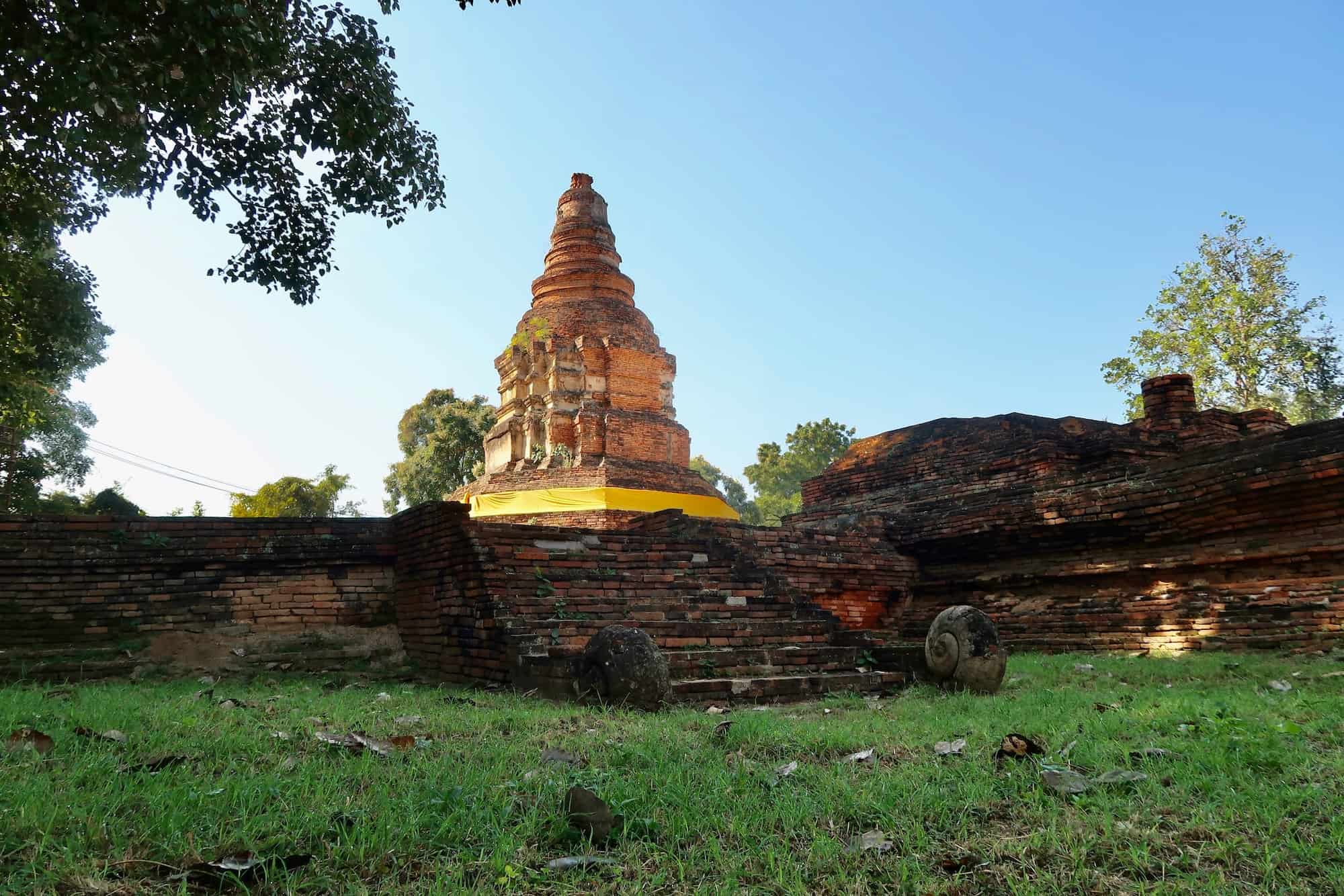
Wat E-Kang | วัดอีก้าง

Wat E Kang is one of the most impressive ruins in all of Wiang Kum Kam. It boasts a large viharn and, most surprisingly, a nearly intact stupa connected by a brick pathway. At the rear of the viharn are stairways on each side leading up to the platform surrounding the stupa.
The large area around the stupa is meant for use as a circumambulation path. In this practice, worshippers walk circles around the stupa in a clockwise direction in order to pay tribute to the sacred object (in this case the relic within the stupa) and gain merit (a credit toward reincarnation).
The viharn has the remnants of 16 pillar bases running through its length and concludes at a very large pedestal that would have once housed the seated Buddha image. However, no trace of the original statue was found during excavations.
A surprising feature is the very small ubosot running alongside the viharn. Not only is it exceptionally small for a viharn and stupa this big, but also in comparison to the rest of the city. As an added curiosity, both the viharn and ubosot face north, whereas most Wiang Kum Kam temples (and Buddhist temples in general) face east.
Wat E Kang temple sits next to Wat Nan Chang with an abandoned event pavilion between them. As of my first (and all subsequent) visits, this group of modern buildings continues to remain out of use. The name of the temple comes from the state it was rediscovered in, whereby the entire area was covered in plant life and inhabited by monkeys (“kang” in northern Thai). However, no monkeys live here or anywhere in Chiang Mai city today.
Excavations at Wat E Kang have been some of the most informative in all the ancient city. The initial excavations and restoration began in 1985, but have continued in short durations ever since due to the property being open for such activities.
Among the substantial finds, an excavation in 1987 found the first solid evidence that the temple and city were subject to one immensely destructive flood, rather than the previously assumed slow destruction by a thousand floods. Continued excavations in 2003 found further ruins of the temple’s boundary wall.
Digs at the site have also found ceramics, inscriptions, and other important artifacts that have informed archaeologists to a more complete picture of the city. More excavations are planned here in the future.
Wat Nan Chang | วัดหนานช้าง

Like its neighbor, Wat E Kang, Wat Nan Chang is one of the most significant excavation finds in Wiang Kum Kam. The temple ruins were buried 1.8 meters below modern ground level and provide clear evidence of at least 2 distinct periods of construction.
In its first period of construction, Wat Nan Chang was only the basic Lanna temple layout of a viharn and stupa behind it. An entry gate (sometimes called a porch) was also found from this early period. However, this first era of construction was later expanded in a second phase of building, resulting in the expansive ruined complex found today.
In my own opinion, the Wat Nan Chang site looks intimidating on the first approach, as the ruins are all in line, densely packed, and there are the actual remains of destroyed and fallen buildings, rather than the simple bases found at other ruins around the city.

Although they do not appear that large at first, as they are removed from ground level in a very long dug-out pit reinforced with concrete. However, walking down into them or even trying to get a single photo including all the structure With so many structures unearthed, the Wat Nan Chang temple complex is only rivaled in size by Wat Ku Pa Dom or Wat Huanong
Wat Nan Chang is also one of the locations in Wiang Kum Kam where clear evidence of Chinese pottery in the Ming dynasty style was found. This not only provides a contemporary date for the city and the site, but also evidence of a political relationship between the fledgling Lanna Kingdom and the hyper-nationalist Ming dynasty of China.
The temple is named for the ancestor of the locals who owned the land where Wat Nan Chang is buried. Like its neighbor, Wat E Kang, it also faces north instead of the usual east of Buddhist temples. Not far from the north end of the temple is another earthen embankment that would have reinforced the city’s northern wall against the waters of the Ping River.
Wat Ku Pa Dom | วัดกู่ป่าด้อม

Wat Ku Pa Dom is one of the most dramatic excavation sites of Wiang Kum Kam when you first see it. The temple ruins here are extremely dense and most still in remarkable condition, even maintaining some of the original walls in full. These ruins are also excavated as far as 2 meters down from the modern ground level, and that drop-off is immediately evident at the roadside.
The temple at Wat Ku Pa Dom sits a small distance outside the southwest city wall of Wiang Kum Kam. It was obviously important given its size and the way the buildings are constructed so closely, very unlike any of the other large temples uncovered throughout the ancient city’s area.
At the core of Wat Ku Pa Dom is the main, southeast-facing viharn and stupa surrounded by an almost entirely-intact boundary wall. Outside this central walled area is another walled area containing additional buildings and indicates several layers and eras of construction.
One of the more unique finds at Wat Ku Pa Dom was the image of a Chinese-style dragon emerging from the makara on a temple entryway, rather than the usual naga. This is extremely rare in Lanna art and the only example found in Wiang Kum Kam.

Excavations at Wat Ku Pa Dom began in 1999 and restoration work continued into 2003. During the digs, archaeologists found votive tablets (Buddhist amulets) in both Lanna and Hariphunchai styles. There were also several sculptures found, including a bronze Buddha head, a sandstone Buddha head (Phayao style), and pottery from Lanna kilns. The temple is named after the owner of the land, however, the ancient name remains unknown.
Wat Ubosot (Wat Bhot) | วัดอุโบสถ (วัดโบสถ์)

Wat Ubosot is a very small temple ruin located outside of the Wiang Kum Kam walled city to the southwest. Although it is named after an ubosot, the Buddhist ordination hall, excavations have only found ruins of a viharn (worship hall) and a stupa. There is also another small brick structure behind the stupa now reclaimed by the forest.
The temple has been perpetually sunken beneath groundwater level since its excavations from 1999-2001. It was covered in sand for a period of time after the final restoration, although it is now exposed and open to visitors, although the path to the temple is off any main road and not well marked.
Uncovered during excavations were multiple Buddhist tablets, a bronze section of the stupa, and pieces of Buddha images made from varying materials (lime stucco, bronze, and sandstone). Several bricks on the viharn and stupa were also inscribed with Fak Kham, an early writing system used by the Lanna Kingdom.
Wat Patan | วัดป่าตาล (*destroyed)

Wat Patan is marked on the official maps and tourist literature as sitting along the east bank of the Ping River. This modern course of the Ping River is different from its ancient course, which would have passed along the longer, northern wall of Wiang Kum Kam. As the course of the river was changed by more recent irrigation projects, it began running along the western wall of Wiang Kum Kam
Wat Patan seems to have been overtaken by the river somewhere in this shift. After extensive searching in the area marked on the maps, there was no sign of the ruins of Wat Patan. There is some discussion that some foundations of the temple can be seen at times when the water level is extremely low, however, I have never seen any sign of this either.
Wat That Noi | วัดธาตุน้อย

Wat That Noi is a small temple just outside the grounds of Wat Chang Kham and was included in the early excavations of Wiang Kum Kam in 1985 due to its proximity. This temple is not mentioned in any historical documents and its true name remains unknown.
The ruins at Wat That Noi follow the basic Lanna temple design of a detached stupa behind a long viharn. The stupa at Wat That Noi features a broad, square base topped with the remains of a comparatively small structure, for which the temple is named (‘that’ meaning relic, often used for a stupa/chedi, ‘noi’ meaning small). This is assumed to have been a pavilion-style stupa, with a roof covering the square base for worshippers to circumambulate.
Like a minority of temples from Wiang Kum Kam, Wat That Noi faces north, toward the old Ping River rather than east, the usual direction of Thai Buddhist temples. Also notable on Wat That Noi are stairways leading up into both sides of the viharn.

However, the most interesting feature of the temple is the remains of the bottom part of the temple’s original Buddha image, seated cross-legged upon its pedestal. Few other temples from this period retain any trace of such an image.
Today, the ruins are protected by a concrete retaining wall preventing the excavated pit from collapsing and re-burying the structure.
Wat Kan Thom (Wat Chang Kham) | วัดกานโถม (ช้างค้ำ)

Wat Kanthom Kumkam Phirom, more commonly called Wat Kanthom or Wat Chang Kham, is one of the ancient Wiang Kum Kam temples that was revived and restored as an active temple today. It seems that in modern references, Wat Kanthom is the name of the ancient temple dating to early Wiang Kum Kam, while Wat Chang Kham is the name of the modern temple built over the ancient ruins.
The name “Kanthom” appears in ancient writings and is believed to have been the name of an important figure involved in the original temple’s construction. Writings from the same era date the original Wat Kanthom temple to around 1290 CE, where it was ordered built by King Mangrai.
These documents describe the early temple as having a stupa 18 meters tall and 12 meters wide. This stupa had 2 levels of niches to display images. The lower level had 4 seated buddhas facing each direction. The upper level had 4 niches with standing figures of semi-legendary status or from Hindu-Buddhist mythology, namely Maudgalyayana and Sariputra (disciples of the Gautama Buddha) and Indra and Phra Mae Thorani (god figures).
Today, only the flat, square base of the stupa remains at Wat Kanthom temple, disconnected and behind the ancient temples viharn, which oddly faces west. This viharn is long and thin with a mondop-like structure attached at the rear. Running the length of this worship hall are 8 square, brick column bases. These end at the entrance to the sealed-off mondop-like hall where the temple’s principal image would be housed.
In this mondop, there is another set of pillar bases, and an octagonal pattern surrounding the Buddha image’s pedestal. While looking at it, it appears there would be enough space for a single worshipper to move around in this open space.

To the west of the excavated ancient viharn is a bodhi tree (though not thought to be an offspring of the original from Bodhgaya) and the Mangrai spirit house, a shrine where locals pay tribute to the founding Lanna king. It is one of several such locations around the city. This spirit house contains a bronze depiction of Mangrai surrounded by royal and sacred imagery.
One last structure just south of the modern temple is designated as “The Church” in English. Although it looks very modern, the documentation onsite says that this appearance is the consequence of many renovations throughout the years and that this structure actually dates back from 1291 CE, built just a year after the original ruined temple nearby.

As noted in the earlier history section, Wat Kanthom (technically the modern Wat Chang Kham then) was the first primary location that traces of the ancient city of Wiang Kum Kam began to surface. This led to the temple grounds hosting the earliest round of excavations of the city in 1986.
Aside from the temple ruins excavated on the southeast of the temple grounds, sandstone tablets bearing different forms of writing helped date both this temple and the whole city to its different eras. This included early tablets with Mon writing from Hariphunchai (Lamphun) dated from 1207-1307 CE, an early form of the transitional writing system between Mon and Lanna scripts dated between 1277-1317, and inscriptions in the Sukhothai and Fak Kham Thai alphabets from the late 1300s CE.
Wat Kum Kam | วัดกุมกาม

Wat Kum Kam is a large temple in the middle of residential buildings. Prior to its excavation, the temple was actually buried under a large mound with local homes built on top. It’s unknown if there was more to this temple or if a significant portion of it was destroyed by the residential encroachment.
Excavations began at Wat Kum Kam in 1986 and uncovered a total of 4 monuments laid out in the common Lanna design. These 4 structures were one very large brick viharn, an octagonal stupa behind the viharn, a small ubosot (ordination hall) facing the opposite direction as the viharn. There is also a small, square-based building behind the ubosot that looks like a stupa but documentation onsite says is a mondop (records hall).

In addition to the buildings, the excavations found fragments of small buddha images made from bronze and limestone. In addition to these smaller relics, hair curls of the principal Buddha image were found. These curls measure 6-8 cm. This, along with the larger-than-normal pedestal in the viharn, lead researchers to conclude the main image here must have been exceptionally large.
Today, Wat Kum Kam is open to the public, but located on a side street leading to a private driveway. Due to its location tightly squeezed in between private homes, the excavation pit has not been expanded to allow proper drainage. This results in one of the more impressive independent temples of Wiang Kum Kam being mostly submerged much of the year, and all but 1 time that I visited the ruins.
Wat Kumkam No. 1 | วัดกุมกาม หมายเลข 1

Wat Kum Kam #1 is named so due to its proximity to Wat Kum Kam (above), despite being closer to Wat Ku Ailan. It’s a small temple following the traditional Lanna design of a viharn with a stupa behind it. Unlike the nearby Wat Kum Kam and Wat Ku Ailan, Wat Kum Kam #1 faces north instead of the usual east.
The stupa remains are of a small brick base barely at the excavated ground level (and about 1 meter below modern ground level). The rest of the structure had been lost long before excavation. Several sections of the enclosure wall have been found surrounding the ruins as well.
This temple was among the later excavations done between 2002-03 and researchers have found no written historical mentions of this specific temple. During excavations, archaeologists from the Fine Arts Department also found fragments of limestone and bronze Buddha images.
The style of the Wat Kum Kam #1 temple viharn is somewhat unique in Wiang Kum Kam. It has flat, rectangular sides, as opposed to the indented grooves that run along the sides and corners of most of the other temples in the ancient city. Also, there are several sections of the viharn base that still have their original stucco attached to the bricks.
Wat Kum Kam #1 is relatively hidden away. There is a small paved driveway that also serves as the entrance to Wat Ku Ailan. If you follow this past Wat Ku Ailan, it leads back into the forest to a private home’s driveway and to the excavation pit of Wat Kum Kam #1.
Wat Ku Ailan | วัดกู่อ้ายหลาน

Wat Ku Ailan is located only 75 meters west of the larger Wat Kum Kam. This temple is in relatively good condition and located in a forest clearing. The remains of almost the entire enclosure wall still surround the site. Wat Ku Ailan was also one of the later excavations in the city, which took place between 1999-2005.
From the street, you’ll be approaching Wat Ku Ailan from the rear. This means its square stupa base is the first part of the monument you’ll see. Just behind (west) the stupa is a small brick base that was either a pedestal or altar. Another can be found on the front (east) side of the stupa, between it and the unconnected viharn, as well as on the north side. It’s safe to speculate that one of these pedestals also existed on the south side, but has since been lost.

The viharn of Wat Ku Ailan is fairly standard for Wiang Kum Kam. One notable feature is that the entrance seems to be marked off by a separate wall within the building. There are the remnant bases of some laterite columns through the main hall on the way to the principal Buddha image, although nothing remains of this statue.
Wat Phan Lao | วัดพันเลา

Wat Phan Lao was the first ruined temple of Wiang Kum Kam that I came across when searching through the labyrinthine neighborhood built over the ancient city. Truth be told, while the open lot is larger than many of the ruins of Wiang Kum Kam, it’s one of the least impressive in the whole archaeological site.
The Phan Lao temple was just outside the original Wiang Kum Kam city wall on the opposite bank of the old Ping River. There is no mention of this temple in written records from either the time of Wiang Kum Kam or after.
Wat Phan Lao’s complex assortment of buildings is the result of later additions to the temple. These are divided into two groups: one group facing east-west and another facing north-south.
The temple was excavated in 2002 and restored afterward, but had already suffered damage from residential expansion and construction. Even today, it is tightly bordered on each side by private homes and the road. Although a good deal of the temple complex was destroyed prior to excavations, the varied assortment of buildings and pieces of fragmented architecture uncovered lead researchers to conclude this was an important temple until the city was abandoned.
Wat Huanong | วัดหัวหนอง

Wat Hua Nong is one of the largest temple ruins in Wiang Kum Kam, taking up an entire residential block. The main entrance is on the north side, and the exceptionally well-preserved base of the ceremonial Khong entrance is still there, and still retains its original stucco designs of swans, flowings, and more.
Once entering the gate from the north, there are at least 4 major structures on the Wat Huanong temple grounds. Immediately to the west of the gate is an east-facing viharn connected to a mondop, a traditionally square or cross-shaped building that often appears like a stupa, but contains a room inside housing relics, documents, or a revered statue/image.

The main viharn and stupa are located on the southwest side of the ruins. The stupa here borrows architectural elements from the earlier Sukhothai style with kneeling elephants lining the base, but they are only on the south side of the ruined stupa today.
This was a tall stupa with niches displaying Buddha images on each side. Its wide base was also pavilion-style, providing a broad brick floor surrounding it where worshippers would circumambulate. There are also several smaller stupas around this main viharn

Wat Huanong began its excavation in 1988 and underwent restoration efforts in 1989 and 2003. Surprisingly, for a temple its size within the city walls, there is no record of its original name. The name “huanong” comes from locals referring to the original mound before excavation surrounded by a swamp. From the size of the ruins there today, the Fine Arts Department expects that there were many more buildings at Want Huanong that were lost to time.
On the east side of the temple near the boundary wall are rectangular buildings forming a T-shape. These are presumed to be the monk’s quarters — one of the few examples of such in the remains of Wiang Kum Kam.
Wat Ku Aisi | วัดกู่อ้ายสี

Wat Ku Aisi is a small temple ruin located near the middle of the ancient walled city of Wiang Kum Kam. Most of the temple is destroyed and submerged underwater and swampland. Locals still actively use the temple in this condition, placing a wooden beam to cross over the water to the ruined brick foundations.
The viharn still has a mostly intact pedestal which is often adorned with a modern, small image or religious token. Behind this viharn are the mostly-devastated ruins of a very small stupa. Its square base is noticeably damaged by water and little remains above the excavated ground level.
Wat Ku Aisi was excavated and restored between 1999 and 2001 and is named after the owner of the land where the temple was found. No mention of the temple or its original name has ever been found in written records.
According to documentation at the site, there is another unexcavated ruin immediately to the south of Wat Ku Aisi, but no information on when or if this will be dug up. There is currently a cement wall surrounding the entire Wat Ku Aisi ruin, and this potential excavation site cannot be readily seen from the temple. However, there are traces of a partially buried brick structure just next to the wall, but it is unclear if this is the unexcavated ruin being referenced.
Wat Ku Tonpho | วัดกู่ต้นโพธิ์ (*destroyed)

Along with Wat Ku Jokpok, Wat Ku Tonpho drove me crazy in trying to locate it. Although its location is vaguely marked on all of the city maps available, like Wat Ku Jokpok and Wat Pa Tan, none of them gave an exact location. Wat Tonpho, however, had street signs pointing the way.
These signs point the way to one road, which dead-ends at Wat Ku Makuluea. They also make it clear that Wat Tonpho is before Wat Ku Makuluea. However, no matter how many times I drove up and down this road, there was no sign, however small, of any excavated ruins that these signs were indicating.
I began expanding the search to neighboring streets that were separated by property walls. Unfortunately, none of these searches resulted in anything other than bringing me back to other residential deadends and Wat Hua Nong over and over again.
During several of these searches, I tried asking local residents in the best Thai I could manage about the temple. Most had no idea about it, however, one construction site on the same street told me that it had been destroyed. He then pointed to the property where the temple ruin has once been saying that it was gone now.
So, despite official literature stating that Wat Ku Tonpho is available for tourists to see, it has since been destroyed, like Wat Pa Tan and Wat Ku Jokpok.
Wat Ku Makuluea | วัดกู่มะเกลือ

Wat Ku Makuluea (also Wat Ku Magleur) is located at the end of a residential street in an area that is usually swampy year-round. The temple was excavated in 1999 and separated from an adjacent property that contains a large pond, which extends into the ruins during the rainy season.
The modern name comes from a kind of tree that once covered the site. However, the temple is mostly submerged within this pond’s extended swamp water most of the year.
The Wat Ku Makuluea temple holds the basic layout of most temples in Wiang Kum Kam, and then later Chiang Mai. However, the brick foundations of the temple remain in relatively good shape and are among the largest, most intact ruins in the ancient city.
The viharn has a large area with the bases of several columns still evident. At the rear of the viharn hall is a large pedestal where the Buddha image would have been placed, although it is now gone. At the entrance to the viharn, is an ornamental half-circle step leading to the stairway into the temple.
The principal stupa of Wat Ku Makuluea is connected to the viharn, although there is no indication that there was an exterior pavilion around this one. The lower levels of this stupa are still mostly intact, although suffering from extensive water damage.
Just behind the stupa is a small section (6 meters) of the temple’s boundary wall that was also found during excavations. These excavations and the subsequent restoration took place from 1999-2000. Other artifacts found were a small, bronze stupa and several broken fragments of small bronze and stuccoed Buddha images.
Wat Ku Khao | วัดกู่ขาว

The imposing Wat Ku Khao marks one of the three main entrances to the ancient city of Wiang Kum Kam, although it was originally outside the ancient city wall. Its exceptionally large square base immediately catches the eye of any passerby on the otherwise tranquil Chiangmai-Lamphun Road.
Sitting atop the base is a classic Lanna-style stupa that still retains some of its original lime stucco-work in the indented section. The stupa’s name Ku Khao (“white stupa”) is presumed to come from the color of this lime plaster. This remaining stucco work is lauded by researchers as a great example of original early Lanna artwork.
Directly to the south of the stupa is a small section of the temple’s original viharn with a pedestal for the Buddha statue. The temple was excavated and restored in 1989, a princess which also uncovered a few scattered remnants of Wat Ku Khao’s original brick boundary wall that can now be seen in its roadside lot.
Wat Kumkam Teepram | วัดกุมกามทีปราม

Wat Kumkam Teepram is unique among the smaller temples of Wiang Kum Kam. It was built just outside of the eastern city wall and contained two viharns, each facing different directions — one east (smaller) and one north (larger), forming an L-shape.
Overall, the site has experienced extensive damage, leaving only these two bases, and no signs of other structures like the boundary walls or stupas. The larger, north-facing viharn also housed the main Buddha image, although this is no longer there.

Most notable on the larger stupa are the stucco decorations on the stairways. These depict a naga (semi-divine snake in Hinduism & Buddhism) emerging from the mouth of a makara (another mythical creature blending either an elephant-fish or a crocodile-fish).
Wat Kumkam Teepram was first excavated in 1999 and work continued there until 2003. No literary or historical work mentions this specific temple, and the name is derived from locals.
Wat Kumkam Teepram No. 1 | วัดกุมกามทีปราม หมายเลข 1

Located less than 100 meters from Wat Kumkam Teepram (above), Wat Kumkam Teepram #1 was named only due to its proximity, not because it was a part of the same temple. However, according to documentation on the site, it is named “Ton Khoi” by locals after a kind of tree growing on the site.
Excavations took place between 2002-03 and found the temple buried more than 1 meter below the present ground level. The main structure is a medium-sized vihara and small stupa connected on the same base, although maintaining a space in between them.

The viharn is well-preserved with a flat brick surface and the bases of 6 square, brick columns running the length of the hall. At the back of the viharn is a well-preserved pedestal that has been kept in operation by the locals. A small, protective shelter has been built over the pedestal and has been filled with revered images by local worshippers.
Behind the viharn is a small prasat-style stupa thought to have been very thin but high, perhaps also a (much) smaller, Mon-style stupa similar to the one found at Wat Chedi Liam. Much of the original stucco work remains on the stupa base and it is those the level above the remaining section housed Buddha images in niches on each side.
Wat Ku Maisong | วัดกู่ไม้ซ้ง

Wat Ku Maisong is the southernmost temple within the walled city of Wiang Kum Kam and is located near the city’s southeast corner. The temple is in a relatively open area and is in remarkably good condition when compared to many other smaller temple ruins in the city.
The Ku Maisong ruins contain a mostly-intact viharn and 2 stupas surrounded by the majority length of its original boundary wall foundations, which also contains part of the temple’s ornamental entrance.
The viharn faces northeast and is connected to the principal stupa, separated by a large pedestal where the main, relatively large Buddha image would have been placed. To the left of this pedestal are stairs leading outside of the viharn and to the entrance of a walled-off area surrounding the stupa, suggesting a pavilion surrounding it.

Near the front-left (northeast) of the viharn is another small stupa, a unique placement for the otherwise normal Lann-style temple layout. This stupa was octagonal, although little remains above the forest level of its original base.
The name “Maisong” is not original and instead comes from a local tree that grows in the area. Wat Ku Maison was excavated and restored between 1989-1990. In addition to the structures, these excavations found several unique items in addition to the usual Buddha statue fragments. These included a miniature stupa made in the Phayao art style, a bronze spoon, terracotta votive tablets, and bricks engraved with Lanna writing.
Wat Ku Ridmai | วัดกู่ลิดไม้

Wat Ku Ridmai is almost impossible to find after the expansion of nearby housing developments. It is completely surrounded by concrete walls on one side and a local warehouse on the other. The only access to the site is through a narrow space next to the warehouse building that is mostly overgrown with shrubs.

Once you get to the Wat Ku Ridmai, you’re basically walking through a swamp. There are 3 structures left of the temple: the main east-facing viharn, a stupa far to the east of the viharn, and a section of boundary wall containing the foundations of a gate.
The locations of the stupa and the gate are unusual, and the boundary wall turns toward the south, away from both the viharn and stupa. This suggests that there were several more structures that once existed here, but they have likely been lost to some combination of the local swamp and the housing developments.
Wat Ko Mamuang Khiao | วัดกอม่วงเขียว

Wat Ko Mamuang Khiao (also Wat Ko Mamuong Khiow) is one of three (formerly four) ruined temples outside the main Wiang Kum Kam area. This temple is located along the ancient route between Chiang Mai and Lamphun on the aptly-named Chiangmai-Lamphun Road. The name Ko Mamuang Khiao is not original and instead stems from a mango tree growing at the site.
Very little remains at the site, and what does is highly damaged by the trees growing on the site. Most obvious is the main viharn, the interior floor of which has been cemented over to protect it from further damage. The viharn faces east and the entrance is marked with small sections of the remnant boundary wall.
No remaining traces of the temple’s principal stupa remain to the rear of the viharn. However, there is a small shrine on the northeast built on a square brick base that appeared aged like the rest of the temple. This is unclear from the information available onsite, though.
Like the other outer temple ruins of Wiang Kum Kam, Wat Ko Mamuang Khiao underwent excavation and restoration during the later phases in 2003-4. In addition to the structures, the finds included pottery from northern Lanna kilns and imported ceramics from Ming China.
Due to its location on a major road, the Wat Ko Mamuang Khiao ruins receive a lot of local visitors who will leave small items or tokens of worship, which are often found wedged in the roots of the trees at the temple.
Wat Phra Lul | วัดพระลุล

Wat Phra Lul (also Wat Phra-ood) is the most distant Wiang Kum Kam temple that is associated with the ancient walled city. Sitting on the south side of Chiang Mai’s Outer Ring Road, the temple is not easy to reach and requires looping through several side roads around the nearby interchange when approaching from the Chiang Mai city (or from Wiang Kum Kam).
It’s suspected that Wat Phra Lul (not the original name) was one of the larger Buddhist monasteries in the area and that several more buildings may have existed at the site. The ruins now consist of the foundations of 4 small buildings, all of which have been heavily damaged by water. Given the state of the remaining core ruins, any auxiliary buildings are likely to be entirely lost.
The stupa standing at the site now has three square bases that have lost all of their original decoration. Near the stupa are three east-facing building foundations, one of which is determined to be the temple’s ubosot. There is also one rectangular building foundation with evidence of being expanded at a later date, although a purpose has not been clearly determined for this building.
Wat Ku Jokpok | วัดกู่จ๊อกป๊อก (*destroyed)
Wat Ku Jokpok is another ruined temple marked on existing tourist literature but no longer in existence. While the majority of Wiang Kum Kam’s ruins are in the space between Mahidol Road and Somphot 700 Year Stadium Road (also called the Middle Ring Road), Wat Ku Jokpok existed south of Middle Ring Road.
There are semi-recent photos of the base of this temple mostly overgrown. However, in the area where Ku Jokpok should be standing, there has been recent construction of new homes. Despite searching for any trace of ruins, it seems that Ku Jokpok has been destroyed.
Wat Bo Namthip | วัดบ่อน้ำทิพย์

Wat Bo Namthip is an early Lanna temple located outside of Wiang Kum Kam. It consists of 2 ruined viharns housed on the grounds of a small, modern temple. Its name refers to a well with sacred water supposedly on the grounds of the temple. A well still exists here, however, it is unused and the brickwork is modern.
This Bo Namthip temple is located on the aforementioned Chiang Mai-Lamphun Road approximately ½ kilometer to the southeast of Wiang Kum Kam’s ancient city wall. The temple ruins here were excavated during the excavations done between 1999-2005.
The ruins at Wat Bo Namthip consist of 2 viharns and are intricately interwoven into the grounds of a living temple, albeit a relatively small one. However, the size of the ruined temple suggests it was an important one during its prime in the late 1400s-early 1500s.
Monument No. 1 is a small, rectangular viharn made of bricks and facing east and is typical of what is seen in other ruined viharns in Wiang Kum Kam. However, there is no sign of the original principal stupa of this temple.

Monument No. 2 is more irregular, consisting of an L-shaped ruined brick base. According to documentation onsite excavators are still unsure whether the shorter of the two is an indented back section to the temple or it was another entrance, hosting the Buddha image at the junction.
The ruined foundations make up most of the temple ground’s area, with the modern temple buildings tucked into the southeast corner. The modern viharn’s design is open-air and minimalist particularly in comparison to other revived temples around the city.
How to Get to Wiang Kum Kam
GPS Coordinates: 18.74918, 99.00044

The ancient city of Wiang Kum Kam is located on the southwest side of Chiang Mai city. It is located in a residential area wedged between the historic Chiang Mai-Lamphun Road, the Ping River, and 2 divided highways.
There are three ways to access the ruins — the “official” entrance at the Wiang Kum Kam Information Center on the Middle Ring Road, and two back entrances — one on along Mahidol Road (the 1st Ring Road) and one on Chiang Mai-Lamphun Road, the historic pilgrimage road between the two eponymous cities.
The best entrance to take depends on how you’re getting there.
If you’re riding a bike or motorbike, Chiang Mai-Lamphun Road makes for a safe and convenient ride while avoiding the traffic of the divided highway roads. Chiang Mai-Lamphun road will bring you past one overpass on Mahidol road. From here, you’ll pass the 89 Plaza shopping center, a police station, and soon see a towering ruined stupa called Wat Ku Khao. The downside of this entrance is that it’s far from the core ruins and navigating through the residential streets now occupying Wiang Kum Kam is difficult. Even, I’ve gotten lost many times trying to find my way back to the main road here.
If you’re taking a car or a taxi, then it would be best to begin at the Wiang Kum Kam Information Center. From here, there are clearly marked roads to the core temples of Wiang Kum Kam, which includes Wat Chedi Liam, Wat Phaya Mangrai, Wat Phra Chai Ong Dum, Wat Pupia, and Wat Nan Chang. The Information Center can also arrange for tours through these on a horse-drawn carriage.
I wouldn’t recommend the 3rd entrance (Mahidol Road) unless it’s conveniently close to you. It’s located on a one-way highway lane and easy to miss. If you do miss it, there is no opportunity to turn around for another 3 kilometers. If you do make the turn, you’ll be on the road to Wat Chedi Liam. While not well-marked, there are signs pointing the way to other ruins from Wat Chedi Liam.
Fast Facts
Fast Facts
Name: Wiang Kum Kam | เวียงกุมกาม
Where: Chiang Mai, Chiang Mai, Thailand
Location: 18.74918, 99.00044
Description: Wiang Kum Kam was the first capital of the Lanna Kingdom within the Ping River Valley. After years of continuous flooding, Wiang Kum Kam was abandoned in 1892 to build Chiang Mai.
Getting there: Wiang Kum Kam can easily be accessed from central Chiang Mai by taxi, motorbike, or even bicycle. The Visitor Center provides guided tours in horse carriages for a fee.
Cost: Free
Glossary
Buddhism
Dharmic religion centered on the belief of karma and release from the cycle of reincarnation. Based on the teachings of Siddhartha Gautama.
chedi
Thai word meaning “stupa”
Chiang Mai
City in northern Thailand and historic capital of the Lanna Kingdom founded by King Mangrai in 1296.
Chiang Rai
City in northern Thailand founded by the Lanna king Mangrai in 1262 CE.
Chiang Saen
City in northern Thailand and historic capital of the Ngoenyang Kingdom until the establishment of its successor, the Lanna Kingdom, in 1293 CE.
Doi Suthep (ดอยสุเทพ)
A revered mountain on the western edge of Chiang Mai. The mountain peak has been used by both the Hariphunchai and Lanna Kingdoms to house sacred Buddhist relic temples.
Dvaravati
Mon-Burmese ethnic group based in modern Nakhon Pathom, Thailand. Responsible for the introduction of Buddhism (Theravada sect) to Thailand.
Hariphunchai
Ancient name of Lamphun, Thailand and the historic capital of the Dvaravati Hariphunchai Kingdom.
Hariphunchai Kingdom
Dvaravati kingdom in northern Thailand (c. 750 – 1292 CE) centered in the modern town of Lamphun. Eventually conquered by the Lanna Kingdom.
Kawila
Lanna prince who led successful campaigns against Burmese domination, liberating Chiang Saen. He led the rebuilding of Chiang Mai after becoming governor of Lampang under the Rattanakosin Kingdom.
Khmer Empire
Hindu-Buddhist kingdom which ruled much of Southeast Asia from their capital at Angkor.
ku
Common name in Thailand for an ancient stone tower. Often used interchangeably with, or in combination with, prang, prasat, or chedi.
Kuena
Lanna king from 1355-1385 CE. He expanded the Lanna domain to its largest extent and founded the Lankawong school of Buddhism in Lanna.
Lampang
City in northern Thailand historically known as Khelang Nakhon. Founded by the Hariphunchai Kingdom to control the Wang River Basin, the city was later absorbed by the Lanna Kingdom.
Lamphun
City in northern Thailand and the historic capital of the Hariphunchai Kingdom.
Lanna Kingdom
Thai kingdom based in northern Thailand and northwestern Laos. Its capitals included Chiang Rai, Wiang Kum Kam, and Chiang Mai.
Mangrai
Final ruler of the Ngoenyang Kingdom (Chiang Saen) and founder of the Lanna Kingdom from 1291-1311 who established Wiang Kum Kam in 1286 and its successor Chiang Mai in 1293.
Mekong River
The world’s 12th longest river, which flows from the Himalayas through China, Myanmar, Laos, Thailand, Cambodia, and Vietnam, into the Pacific Ocean.
Mon
Ethnic group originating in Myanmar who established the first civilizations in modern Thailand. The Mon kingdoms in Thailand are collectively referred to at Dvaravati.
naga
Mythological serpents in Hindu-Buddhist tradition said to possess divine powers.
Ngoenyang Kingdom
Tai kingdom based in Chiang Saen, which was succeeded by the Lanna Kingdom after the establishment of Chiang Mai
Pagan Kingdom
Burmese empire that controlled Myanmar from 1044-1297 CE
prasat
Thai and Khmer word meaning “castle”, “tower”, or “temple” most often used in reference to Khmer stone prangs and ruins, and occasionally for Thai brick stupas.
San Kamphaeng Kilns
Lanna-era pottery kilns located east of the city of Chiang Mai.
Sukhothai
City in central-northern Thailand and abandoned capital of the Sukhothai Kingdom.
Sukhothai Kingdom
Thai kingdom establishing in north-central Thailand after overthrowing Khmer Empire rulers of Sukhodaya. The kingdom prospered for over a century before succumbing to the growing power of Ayutthaya.
Theravada Buddhism
“The “Doctrine of the Elders” branch of Buddhism which draws its teachings from the Pali Canon. This sect is popular in Sri Lanka, Myanmar, Laos, Cambodia, and Thailand.
ubosot
The ordination hall of a Buddhist temple.
viharn
The main worship hall in a Buddhist temple.
wat
Thai word meaning “temple”
wiang
Lanna Thai word for “walled city”
Wiang Kum Kam
The first city established by the Lanna Kingdom in the Chiang Mai valley. Abandoned after successive years of flooding to establish Chiang Mai.
Wiang Nopburi
Abandoned Lawa walled city used as a based from which to build Chiang Mai. Located in the northwest corner of Chiang Mai’s Old City in the current location of Wat Chiang Man.
Wiang Tha Kan
A satellite city of Hariphunchai later occupied and expanded by the Lana Kingdom.
Yuan dynasty
The ruling dynasty of China from 1271-1368 CE. Yuan was founded after the Mongol conquest of China and continued expansion of their territory.
Sources
- The 8th Regional Office of Fine Arts Department, Chiang Mai. Wiang Kum Kam: The Dawn of Nop Buri Si Nakhon Ping Chiang Mai, Ministry of Culture.
- The 8th Regional Office of Fine Arts Department, Chiang Mai. Wiang Kum Kam’s Way of Life, Ministry of Culture.
- “The Ancient Objects of Hariphunchai Style” display. Wiang Kum Kam Informational Center, Chiang Mai, Thailand.
- “Ancient Objects that Suggest External Religious Influences” display. Wiang Kum Kam Informational Center, Chiang Mai, Thailand.
- “Archaeological Work at Wiang Kum Kam” display. Wiang Kum Kam Informational Center, Chiang Mai, Thailand.
- “Architecture in Wiang Kum Kam” display. Wiang Kum Kam Informational Center, Chiang Mai, Thailand.
- “Art Work in Wiang Kum Kam” display. Wiang Kum Kam Informational Center, Chiang Mai, Thailand.
- Bunbut, Taksina, et al. “Challenges of the Tourism Management in Lampang and Lamphun: Queen Chammathevi’s Pilgrimage Route.” DSpace at Silpakorn University: Challenges of the Tourism Management in Lampang and Lamphun: Queen Chammathevi’s Pilgrimage Route, Silpakorn University, ithesis-ir.su.ac.th/dspace/handle/123456789/2351.
- “Chedi Liam (Ku Kham)” display. Wiang Kum Kam Informational Center, Chiang Mai, Thailand.
- “The Chedi of Wat E-Kang” display. Wiang Kum Kam Informational Center, Chiang Mai, Thailand.
- “The Chedi of Wat Pupia” display. Wiang Kum Kam Informational Center, Chiang Mai, Thailand.
- “Chiang Mai: Capital City of Lanna” display. Chiang Mai National Museum, Chiang Mai, Thailand.
- “Chinese ceramics found at Wiang Kum Kam” display. Chiang Mai National Museum, Chiang Mai, Thailand.
- “Excavation at Wat Ku Pa Dom” display. Wiang Kum Kam Informational Center, Chiang Mai, Thailand.
- Grabowsky, Volker. “POPULATION AND STATE IN LAN NA PRIOR TO THE MID-SIXTEENTH …” Siam Society, The Journal of the Siam Society, 2005, thesiamsociety.org/wp-content/uploads/2005/03/JSS_093_0b_Grabowsky_PopulationAndStateInLannaPriorToMid16th.pdf.
- “History of Northern Thailand: Hariphunchai Region” display. Chiang Mai National Museum, Chiang Mai, Thailand.
- Lekuthai, Phaisal. “[PDF] Lanna Culture and Social Development: A Case Study of Chiangmai Province in Northern Thailand: Semantic Scholar.” Undefined, 1 Jan. 1970, www.semanticscholar.org/paper/Lanna-Culture-and-Social-Development%3A-A-Case-Study-Lekuthai/ff185c40122f61fc2026788eeea37b76dc96abdb.
- Ng, Serene, et al. “Ancient Floods, Modern Hazards: the Ping River, Paleofloods and the ‘Lost City’ of Wiang Kum Kam.” Natural Hazards, vol. 75, no. 3, 2014, pp. 2247–2263., doi:10.1007/s11069-014-1426-7.
- “Phya Mangrai” display. Wiang Kum Kam Informational Center, Chiang Mai, Thailand.
- Pongpandecha, Narong and Ken Taylor. “Interpretation of the Cultural Landscape and Heritage Values of “Mae Koong Bok Village”, Tambon Sanklang, San Patong District, Chiang Mai, Thailand.” Suthiparithat Journal, 93rd ed., vol. 30, Dhurakij Pundit University, Bangkok, Thailand, 2016.
- Swearer, Donald K., and Sommai Premchit. The Legend of Queen Cāma: Bodhiraṃsis Cāmadevīvaṃsa, Translation and Commentary. State University of New York Press, 1998.
- “The Church” informational sign. Wat Chang Kham, Chiang Mai, Thailand.
- “Wat Bo Namthip” informational sign. The 8th Regional Office of Fine Arts, Chiang Mai. Chiang Mai, Thailand.
- “The Spirit Chamber of Mengrai the Great” informational sign. Wat Chang Kham, Chiang Mai, Thailand.
- “Wat Changkam” metal informational sign. The 8th Regional Office of Fine Arts, Chiang Mai. Chiang Mai, Thailand.
- “Wat Chang Kham (Wat Kan Thom), Wiang Kum Kam” informational sign. The 8th Regional Office of Fine Arts, Chiang Mai. Chiang Mai, Thailand.
- “Wat Chediliem” informational sign. The 8th Regional Office of Fine Arts, Chiang Mai. Chiang Mai, Thailand.
- “Wat E Kang” informational sign. The 8th Regional Office of Fine Arts, Chiang Mai. Chiang Mai, Thailand.
- “Wat Huanong” informational sign. The 8th Regional Office of Fine Arts, Chiang Mai. Chiang Mai, Thailand.
- “Wat Hua Nong” informational sign. The 8th Regional Office of Fine Arts, Chiang Mai. Chiang Mai, Thailand.
- “Wat I-Khang” informational sign. The 8th Regional Office of Fine Arts, Chiang Mai. Chiang Mai, Thailand.
- “Wat Kan Thome (Chang Kham)” wooden informational sign. The 8th Regional Office of Fine Arts, Chiang Mai. Chiang Mai, Thailand.
- “Wat Ko Mamuang Khiao (Wat Ko Mamuong Khiow)” informational sign. The 8th Regional Office of Fine Arts, Chiang Mai. Chiang Mai, Thailand.
- “Wat Ku Aisi” informational sign. The 8th Regional Office of Fine Arts, Chiang Mai. Chiang Mai, Thailand.
- “Wat Ku Khao” informational sign. The 8th Regional Office of Fine Arts, Chiang Mai. Chiang Mai, Thailand.
- “Wat Ku Khao (abandoned)” informational sign. The 8th Regional Office of Fine Arts, Chiang Mai. Chiang Mai, Thailand.
- “Wat Kumkam” informational sign. The 8th Regional Office of Fine Arts, Chiang Mai. Chiang Mai, Thailand.
- “Wat Kumkam No. 1” informational sign. The 8th Regional Office of Fine Arts, Chiang Mai. Chiang Mai, Thailand.
- “Wat Kumkam Teepram” informational sign. The 8th Regional Office of Fine Arts, Chiang Mai. Chiang Mai, Thailand.
- “Wat Kumkam Teepram No. 1” informational sign. The 8th Regional Office of Fine Arts, Chiang Mai. Chiang Mai, Thailand.
- “Wat Ku Maisong” informational sign. The 8th Regional Office of Fine Arts, Chiang Mai. Chiang Mai, Thailand.
- “Wat Ku Makuleua” informational sign. The 8th Regional Office of Fine Arts, Chiang Mai. Chiang Mai, Thailand.
- “Wat Kum Kam Teepram (abandoned)” informational sign. The 8th Regional Office of Fine Arts, Chiang Mai. Chiang Mai, Thailand.
- “Wat Ku Padom” informational sign. The 8th Regional Office of Fine Arts, Chiang Mai. Chiang Mai, Thailand.
- “Wat Ku Pa Dom” informational sign. The 8th Regional Office of Fine Arts, Chiang Mai. Chiang Mai, Thailand.
- “Wat Nanchang” informational sign. The 8th Regional Office of Fine Arts, Chiang Mai. Chiang Mai, Thailand.
- “Wat Phan Lao” informational sign. The 8th Regional Office of Fine Arts, Chiang Mai. Chiang Mai, Thailand.
- “Wat Phra Chao Ong Dam-Phaya Mangrai” informational sign. The 8th Regional Office of Fine Arts, Chiang Mai. Chiang Mai, Thailand.
- “Wat That Kaow” informational sign. The 8th Regional Office of Fine Arts, Chiang Mai. Chiang Mai, Thailand.
- “Wat Thatkhao” informational sign. The 8th Regional Office of Fine Arts, Chiang Mai. Chiang Mai, Thailand.
- “Wat That Khao” informational sign. The 8th Regional Office of Fine Arts, Chiang Mai. Chiang Mai, Thailand.
- “Wat Pupia” informational sign. The 8th Regional Office of Fine Arts, Chiang Mai. Chiang Mai, Thailand.
- “Wat Pu Pia” informational sign. The 8th Regional Office of Fine Arts, Chiang Mai. Chiang Mai, Thailand.
- “Wat Phra Chao Ong Dam-Phaya Mangrai” informational sign. The 8th Regional Office of Fine Arts, Chiang Mai. Chiang Mai, Thailand.
- “Wat Phra Lul (Wat Phra-ood)” informational sign. The 8th Regional Office of Fine Arts, Chiang Mai. Chiang Mai, Thailand.
- “Wat Thatnoi” informational sign. The 8th Regional Office of Fine Arts, Chiang Mai. Chiang Mai, Thailand.
- “Wat That Noi” informational sign. The 8th Regional Office of Fine Arts, Chiang Mai. Chiang Mai, Thailand.
- “Wiang Kum Kam” display. Chiang Mai National Museum, Chiang Mai, Thailand.
- “Wiang Kum Kam” display. Hariphunchai National Museum, Lamphun, Thailand.
- “Wiang Kum Kam” informational sign. The 8th Regional Office of Fine Arts, Chiang Mai. Chiang Mai, Thailand.
- “กำเนิดเวียงกุมกาม (Origin of Wiang Kum Kam).” กรมศิลปากร , The Department of Fine Arts, www.finearts.go.th/main/view/23593-กำเนิดเวียงกุมกาม.
- “Wat Pupia” informational sign. The 8th Regional Office of Fine Arts, Chiang Mai. Chiang Mai, Thailand.


Wow, that’s a hell of a guide there ! Haven’t written my thought on that place yet but I’m sure it won’t be that complete !
Thanks for taking a look, Romain. Are you currently in Thailand?
Very impressive. Very well structured and researched!
Thanks for taking a look!