Archaeological travel guide to the fortifications and ruined temples of Ancient Kanchanaburi — a remote Ayutthaya-era settlement used as a military outpost against Burma.

Much of the Thai national identity is based in the city and kingdom of Ayutthaya, the Central Thai state which would eventually coalesce with the neighboring Sukhothai and Lanna Kingdoms to become the modern nation. During this earlier, fragmented period, the Ayutthayan kingdom faced rivals on several sides including the Lanna Thais, the Khmers, and most notably the Burmese.
Ancient Kanchanaburi is a ruined military outpost on the western edge of the Ayutthaya Kingdom. It provided a strategic vantage point along the Khwae Yai River and also hosted several temples until the town was relocated to modern Kanchanaburi in 1831.
The ruins of Ancient Kanchanaburi still exist, straddling the western edge of Thai territory. Here, we’ll examine the history of the former kingdom’s military outpost, and go over the information you need to visit them yourself.
Contents
The Story of Ancient Kanchanaburi

Ancient Kanchanaburi in the Ayutthaya Period
Main article: Cultural Profile: Ayutthaya Kingdom, the Buddhist State of Siam
For much of its existence, Ayutthaya and its namesake kingdom (as well as its sister kingdom, Lanna) were in conflict with several successive ruling Burmese dynasties. Along with being along the western edge of Ayutthaya territory bordering Burma, Kanchanaburi was along trade routes between several important Thai cities, including Suphanburi and Ratchaburi.

In the late 1700s CE, this western frontier became one of the battlegrounds for these Thai-Burmese Wars. Although there is archaeological evidence of the temples at the core of the city (Wat Khun Phaen, Wat Mae Mai Neua, and Wat Mae Mai Tai) existing earlier, it is in the late 1700s that King Rama I fortified the area for battle against the Burmese.
The Old City of Kanchanaburi was the base from which King Rama 1 launched at least one battle, the Battle of Thung Lat Ya (or the Nine Armies Battle) in 1785, which succeeded in driving back the Burmese advance.
This Kanchanaburi settlement would go one as an active center through the end of the Late Ayutthaya Period and into the Early Rattanakosin Period until 1831, when the town would be moved ~20 km downstream to where the modern Kanchanaburi provincial capital is today.
Kanchanaburi in the Khmer Period

The area that is now Kanchanaburi was inhabited for many centuries before the Ayutthaya Kingdom established their presence there. During the First Millennium CE, the Mon Dvaravati culture established itself in the area, with their first major settlement being U Thong, about 70 km from modern Kanchanaburi, with other, smaller settlements nearer Kanchanaburi, such as at Phong Tuk and Muang Sing.
Around 1100 CE, Muang Sing was taken by the Khmer Empire, who were based in Angkor and controlled the region from Lavo (modern Lopburi). At Muang Sing — about 30km from modern Kanchanaburi and 20km from Ancient Kanchanaburi — the Khmers erected a heavily fortified walled city along a strategic bend on the Khwae Noi River.


The Ayutthayan Thais (and earlier Sukhothai) had a historical habit of inhabiting former Khmer cities and further developing them into Thai cultural centers. This was the case with Lopburi, Sukhothai, and Si Satchanalai, among others. It seems strange to me that the Ayutthaya rulers chose to build this small fortification at the site of Ancient Kanchanaburi instead of utilizing the nearby Khmer walled city at Muang Sing, which would have been long abandoned by the 1700s.
Ancient Kanchanaburi in the Modern Period

Ancient Kanchanaburi was ultimately abandoned in 1831 when the Thai King Rama III founded the modern city of Kanchanaburi. In the time since the Old City of Kanchanaburi was abandoned, the area was still inhabited, although likely remained mostly agricultural as it is now. Meanwhile, Wat Kanchanaburi Kao (Old Kanchanaburi Temple) remained an active local Buddhist center and community school.
Excavations of Ancient Kanchanaburi took place in the beginning in the late 1980s, with restoration work taking place in 2009. Since that time, the ruins at Ancient Kanchanaburi have been open to the public, although rarely promoted as a tourist destination.
Visiting Ancient Kanchanaburi
My first trip to Kanchanaburi was December of 2011. During this trip, I learned of the Khmer ruins at Muang Sing Historical Park and drove out to explore them on Christmas morning. During subsequent years, I made several return trips to Kanchanaburi, but never heard of these Ayutthaya-era ruins during any of these trips.
It turns out that they are hardly prompted at all, even in Thai publications, despite restoration work having been completed on them back in 2009. When I finally learned about them recently, I was surprised to say the last that I never had before.

Like most people who would want to visit Ancient Kanchanaburi, I began from the modern town of the same name. The main tourist strip in Kanchanaburi is located on Mae Nam Kwai Road between the train station/WW2 Cemetery and the “Bridge Over the River Kwai” made from the movie of the same name. This tourist strip has most of the town’s riverside hotels, bars and foreign restaurants, and tour agencies. It was from one of these agencies that I rented a car (and motorbikes on previous trips) for my ride out to the Kanchanaburi ruins.
From the town, the drive takes about 20 minutes if you’re taking the main road, Highway 3199. Although 3199 leads to Wat Pa Lelai first, I ended up taking a back road through the local residential area, which brought me to Wat Kanchanaburi Kao and the Northeastern Fortress first.
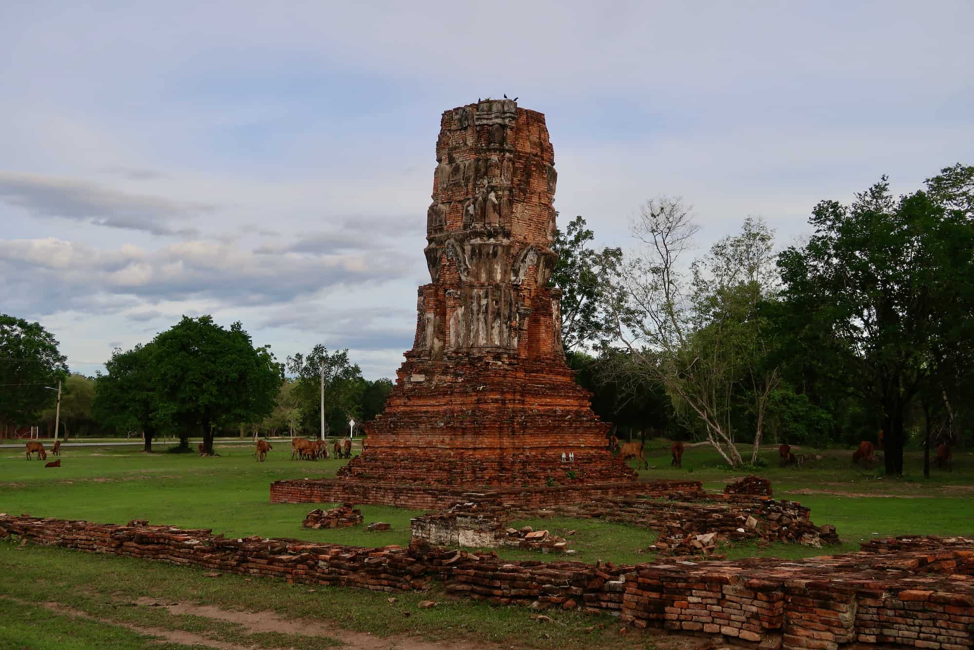
From Wat Kanchanaburi Kao, there is a small road heading north to Road 3199, which goes through the heart of the Kanchanaburi Old City and the main ruins are found on either side of this road. AS I pulled off the roadside to walk out to the ruins, I had to compete with a herd of cows to reach the iconic Ayutthaya prang at Wat Khun Phaen.
Ancient Kanchanaburi Atlas

Map of Ancient Kanchanaburi
The Kanchanaburi Old City is located where the Lam Taphoen River merges with the Khwae Yai River. On the northeastern bank of this confluence is a high earthen embankment (167 x 355 m) which provides a strategic view over the surrounding area and anything that might be coming from upstream. It was on this embankment where the fortifications of Ancient Kanchanaburi were built.
There are four stone corner fortifications which mark the edges of Ancient Kanchanaburi’s defensive perimeter. Each of these fortifications was connected by an earthen wall, with the main settlement upland from these, built on the flat plain to the north of the fortifications.
On the plain just north of the fortifications are the ruins of four Ayutthaya-era temples. The area is real and home to some scattered residential neighborhoods, although none directly surrounding the main temples of Ancient Kanchanaburi.
Wat Kanchanaburi Kao (Wat Nang Pim)

The centerpiece of the entire area is Wat Kanchanaburi Kao (also Wat Nang Pim) ( วัดกาญจนบุรีเก่า (วัดนางพิม)), which sits at the center of the ancient city’s fortifications and along the high embankment overlooking the Khwae Yai River. The temple dates back to the original city but has been continuously renovated for modern use.
The temple grounds have a large number of buildings, including monks quarters, a crematory for local funerals, and even an adjacent school. At the center of the temple is the main modern ubosot and stupa.
The ubosot is surrounded by sema stones and is east-facing, as is common in Thai Buddhist temples. This is curious, though, as most of the ruined temples nearby are all facing toward the west. Behind this ubosot is a small, bell-shaped white stupa. During my visit, the ubosot was closed and locked, so I was not able to see the interior.
Ancient Kanchanaburi Northeastern Fortress

The Northeastern Fort is the closest to the rest of Ancient Kanchanaburi’s ruins and the one you’re most likely to see without actively looking for these forts. It sits on the main road that passes by the modern Wat Kanchanaburi Kao, and is just a few steps from both the road and the temple’s outer wall.
This fortification, like the others, is made of stacked stones with its outer corner oriented toward the northeastern. On the inner (western) side, there are stairs going to the top of the fort. Curiously, at the top of the stairs is a large tree that has been growing out of the fort.
Ancient Kanchanaburi Southeastern Fortress

The Southeastern Fort is located on the grounds of Wat Kanchanaburi Kao — more specifically at the southeastern edge of the temple’s school. This fort corner is mostly surrounded by tall grasses (at the time of my visit) and was strategically positioned for a panoramic view over the Khwae Yai River, the plains across the stream, and the distant mountains.
As part of the modern restoration attempts, the top of these forts have been lined with tiles to protect the structure from both the elements and any damage from people climbing on top of them.
Ancient Kanchanaburi Southwestern Fortress

The Southwestern Fort is the closest of the fortifications to the confluence of the two rivers and was the most difficult of the four to find. It’s located on a high piece of land that if cleared of trees (which it likely would’ve been during ancient habitation), would give the strategic view needed to defend the riverway and the low riverbank below — where there is currently a campground located.
Parking on the main road, I had to actually climb the earthen embankment through somebody’s private land to find this fort. Although there was a frame for one of the informational signs that usually accompanies such ruins, this one was empty and appeared to be left to rampant overgrowth from the local plant life.

The stairs of the Southwestern Fort face inward toward the north. However, the grasses were quite thick, and I didn’t want to further intrude on the property, so I only photographed this fort from the edge of the denser foliage.
Ancient Kanchanaburi Northwestern Fortress

The Northwestern Fort is found down a side road that begins near the inner embankment of the Southwestern Fort. This road also dead-ends/leads into the clearing where Wat Pa Lelai is located a little further north.
Like the other forts, this Northwestern Fort is built of stacked stones with a stairway on the inner-facing side. To reach this fort, I needed to walk through some dense brush (not as thick as the Southwestern Fort) and their accompanying spiderwebs. Joining me on this short hike was the pleasant company of some local dogs belonging to a nearby home.
Wat Khun Phaen

Wat Khun Phaen (วัดขุนแผน) is the ruined temple that will immediately stand out from the rest due to its iconic Ayutthaya-style prang stupa. The prang is much smaller than those found at other Ayutthaya-era sites and bears style elements from the early-to-middle Ayutthaya period. Much of the outer stucco has eroded away, leaving bare brick and the top of the prang is missing.
To the west of the prang are a west-facing ubosot and several auxiliary stupas (called chedi rai in Thai). Although they are relatively large, there is little to be discerned from the ubosot ruins. Surrounding all these ruins is the foundation of a low boundary wall.

Wat Khun Phaen is presumed to have been constructed in the 1500s CE, based on its style, being built as the central temple of Ancient Kanchanaburi. The temple was excavated in 1989 and preservation efforts took place in 2009.
Wat Mae Mai Nuea

Wat Mae Mai Neua (วัดแม่หม้ายเหนือ), or “Northern Widow Temple”, is another of the core temples of Ancient Kanchanaburi. Like the Wat Khun Phaen, this temple is west-facing and consists of a round bell-shaped stupa with an accompanying viharn.
During the 1990 excavations, archaeologists found evidence of clay roof tiles, wooden structures, and metal nails used to hold them together. This has led to the conclusion that the brick viharn had a wooden roof structure that was lined with roof tiles, however, the wooden parts have long since rotted away.
The same excavation found that Wat Mae Mai Neua was built during two phases, a second phase building over the first. It also found the remains of a low boundary wall surrounding the entire temple compound. Following the excavations, the temple underwent preservation efforts in 2009.
Wat Mae Mai Tai

The second of the eastern core temples, Wat Mae Mai Tai (วัดแม่หม้ายใต้), or “Southern Widow Temple”, is located immediately south of Wat Mae Mai Neua. Wat Mae Mai Tai is the only one of the core Ancient Kanchanaburi temples to feature the traditional east-facing orientation.
The temple consists of the aforementioned east-facing viharn and several auxiliary satellite stupas (chedi rai). One of these stupas was discovered to have been a prang rather than the normal bell-shaped stupas that otherwise surround the temple.

Like its neighboring Wat Mae Mai Neua, Want Mae Mai Tai was excavated in 1990. During the excavations, the archaeologists discovered two phases of construction. In the latter era of the temple, the viharn was modified to resemble a ship bilge, a trend that was popular during the later Ayutthaya period.
Wat Pa Lelai

Wat Pa Lelai (also Wat Pa Lay Laig วัดป่าเลไลย์ ) is the most complete and monumental of the ruined Kanchanaburi temples, hosting an ancient viharn as well as an intact seated Buddha statue within its mondop — however, this statue is not the original.
This position of the current Buddha statue is called Pang Pa Lelai, from which the temple gets its name, and means “sitting with his legs down”. The original position of the Buddha was the more commonly seen “Subduing Mara” pose — in which the Buddha is sitting cross-legged with his right hand over his legs and his left hand open on his lap.

The most famous ancient monument with this Subduing Mara pose is almost certainly Sukhothai’s Wat Si Chum, which is also a square mondop building containing a large seated Buddha statue.
Behind the mondop is a semi-ruined brick viharn. This viharn has been preserved and covered with a modern roof. Inside is a small, relatively rough Buddhist shrine.
There is one ruined stupa directly behind the viharn and a second nextt to that. This principal stupa has an unusual shape for a Thai stupa — a large, round stupa with a narrow base topped with a bulbous round structure on top. It would have originally been topped off in a bell-shape, however, the top of the stupa has been lost.
There is another stupa base next to this principle stupa, but nothing remains over the base. The entire ruined temple complex is set in a forest clearing, far more atmospheric than the open fields where the other temples are located, and is surrounded by a low boundary wall, like the other temples of Ancient Kanchanaburi.
How to Get to Ancient Kanchanaburi
GPS Coordinates: 14.1166, 99.40088

The Old City of Kanchanaburi is located nearly 20 km from the modern town center and provincial capital of Kanchanaburi. While Kanchanaburi has city tuk-tuks and motorbike taxis, there is no system of public transit beyond the city limits with the exception of tour operators.
There are, however, several independent tour operators and travel businesses (guest houses, etc.) that will rent motorbikes or cars that will more easily allow you to explore the area. While I wouldn’t dare drive in the Bangkok area, the roads around Kanchanaburi are relatively peaceful and flat.
Motorbike rentals tend to go for about THB 300 (USD 10) per day, while car rentals cost around THB 1000 (USD 30) per day.
Fast Facts
Fast Facts
Name: Kanchanaburi Old Town (โบราณสถาน ในเขตเมืองกาญจนบุรีเก่า)
Where: Kanchanaburi, Kanchanaburi Province, Thailand
Location: 14.1166, 99.40088
Description: Ayutthaya-era settlement used as a western frontier outpost along the Burmese border.
Getting there: Private transportation is needed.
Cost: Free
Glossary
Angkor
Capital of the Khmer Empire, located near modern day Siem Reap, Cambodia.
Ayutthaya
City in central Thailand and historic capital of the Ayutthaya Kingdom, which was succeeded by the Thonburi Kingdom in 1767.
Ayutthaya Kingdom
Thai kingdom based in central Thailand, later referred to as Siam. Its capital was the city of Ayutthaya until the city was destroyed by the Burmese, forcing the state of Siam to relocate to modern Bangkok and found the Thonburi Kingdom in 1767.
Bridge Over the River Kwai
Modern reconstruction of the Burma Railway bridge built in Kanchanaburi by the Japanese using prisoner-of-war labor. The bridge was made famous by the 1957 film of the same name.
Buddhism
Dharmic religion centered on the belief of karma and release from the cycle of reincarnation. Based on the teachings of Siddhartha Gautama.
Dvaravati
Mon-Burmese ethnic group based in modern Nakhon Pathom, Thailand. Responsible for the introduction of Buddhism (Theravada sect) to Thailand.
Khmer Empire
Hindu-Buddhist kingdom which ruled much of Southeast Asia from their capital at Angkor.
Lanna Kingdom
Thai kingdom based in northern Thailand and northwestern Laos. Its capitals included Chiang Rai, Wiang Kum Kam, and Chiang Mai.
Lavo Kingdom
Dvaravati kingdom in central Thailand centered in the modern town of Lopburi. Eventually conquered by the Khmer Empire.
Lopburi
City in northern Thailand and historic capital of the Lavo Kingdom founded by the Dvaravati culture. It was subsequently ruled by the Khmer Empire and the Ayutthaya Kingdom.
mondop
Square building with pointed or pyramidal roof used to house Buddhist relics, documents, or shrines.
Muang Sing
Walled Angkorian city on the western edge of ancient Khmer territory, near the Burmese border of of modern Thailand.
Mon
Ethnic group originating in Myanmar who established the first civilizations in modern Thailand. The Mon kingdoms in Thailand are collectively referred to at Dvaravati.
prang
A Khmer Hindu tower representing Mount Meru and taking the form of a lotus bud. Thai architecture later adopted the design into their Buddhist temples.
Rattanakosin Kingdom
Thai kingdom and successor to the Thonburi Kingdom. Based in Bangkok and founded in 1782, the Rattanakosin era lasted until 1932, when political reforms transformed the kingdom into the modern nation of Thailand.
stupa
Buddhist monument used to enshrine sacred relics or memorialize important figures. Its dome, bell, or otherwise tower-like appearance is an architectural representation of Mount Meru, the cosmic mountain said to represent the structure of the universe in Hindu-Buddhist cosmology.
Sukhothai
City in central-northern Thailand and abandoned capital of the Sukhothai Kingdom.
Sukhothai Kingdom
Thai kingdom based in central-northern Thailand, after the overthrow of Khmer rules. Its capital was the city of Sukhothai, which was later conquered and absorbed by the Ayutthaya Empire.
sema stone
Boundary stones used to mark the sacred inner areas of a Theravada Buddhist temple, particularly in Thailand.
Three Pagoda Pass
Mountain pass in western Kanchanaburi Province linking Thailand and Myanmar.
ubosot
The ordination hall of a Buddhist temple.
viharn
The main worship hall in a Buddhist temple.
Sources
- “Wat Pa Lelai” informational sign (translation). Department of Fine Arts. Kanchanaburi Ancient Town, Kanchanaburi, Thailand.
- “Wat Khun Phaen” informational sign (translation). Department of Fine Arts. Kanchanaburi Ancient Town, Kanchanaburi, Thailand.
- “Wat Mae Mai Neua” informational sign (translation). Department of Fine Arts. Kanchanaburi Ancient Town, Kanchanaburi, Thailand.
- “Wat Mae Mai Tai” informational sign (translation). Department of Fine Arts. Kanchanaburi Ancient Town, Kanchanaburi, Thailand.
- “ โบราณสถานในเขตเมืองกาญจนบุรีเก่า.” Welcome to Kanchanaburi, kanchanaburi.go.th/au/tourkan2015/bolansathan.php.
- Amazing Thailand. Kanchanaburi, TAT Thailand, 2018, amazingthailand.com.au/wp-content/uploads/2018/10/Kanchanaburi-Eg-60-61-resize-1535364859.pdf.
- “วัดขุนแผน.” Thailand Tourism Directory, Ministry of Tourism and Sports, thailandtourismdirectory.go.th/th/info/attraction/detail/itemid/4790.
- “เมืองเก่ากาญจนบุรี.” แหล่งศิลปกรรมอันควรอนุรักษ์ – สิ่งแวดล้อมศิลปกรรม, 3 Apr. 2019, culturalenvi.onep.go.th/site/detail/2600.


