Archaeological Travel Guide to the ruins of Tongwancheng, a 2000-year-old walled city built just outside the Great Wall by the Xiongnu (Huns), ancient China’s most enduring enemy.

China is a vast landscape still dotted with ancient relics. For each well-known museum and historical tourist site like the Great Wall and the Forbidden City, there are numerous others that are lesser known. Tongwancheng in Shaanxi is one of these places — once the capital of the fiercest enemies of the Chinese emperors, this ancient city is now a ghostly ruin amidst the dry mountainscapes of northern China.
Tongwancheng was founded in 419 CE as the capital of the Xiongnu (Southern Huns). Built by Helian Bobo of the Hu Xia dynasty, it served as a commercial and military center due to its Silk Road location. The city vanished from Chinese records in the 15th Century and was only surveyed in the 21st Century.
This article will guide you through the history of Tongwancheng from its early days warring with the Chinese, its fall into obscurity, and the modern efforts to excavate and preserve the site. Following my own firsthand experience, I’ll provide you all the information you’ll need to visit ancient Tongwancheng for yourself.
Contents
The Story of Tongwancheng

Since the days of the earliest Chinese kingdoms, the Xiongnu nomadic tribes had served as antagonists to the settled cities of the Middle Kingdom. Ranging from raids on frontier towns to all-out wars against the later dynastic kingdoms of Qin and Han, the Xiongnu proved a persistent thorn in China’s side for centuries.
In the later days of the Xiongnu, their capital at Tongwancheng was no exception to this antagonistic relationship. Built only a short distance from the Great Wall, it positioned the Xiongnu of the Hu Xia dynasty (407 – 431 CE) within easy striking distance of their southern neighbors.
Although relatively unknown, Tongwancheng is undoubtedly an important historical site in the region. It is one of the only Hunnic cities extant in Inner Asia and is one of the few existing Hunnic capitals globally.
Early Accounts of Tongwancheng
The most detailed record of Tongwancheng, including the building of the city, comes from the Chinese historical text, the Book of Jin. This text originated as a history of the Jin dynasty (266 – 420 CE) that would once again unite most of China following the Three Kingdoms and Sixteen Kingdoms period. During their reign, they were in conflict with the Xiongnu of Tongwancheng, and recorded their experience with the city.
According to the Book of Jin, the Xiongnu city was built by 100,000 men and, at the height of its grandeur, it was home to about 10,000 families (estimated to be about 70,000 people).
It’s from this reference that the city gets the name it is best known by. When translated to English, Tongwancheng means the “city ruling ten thousand”.
The city has been given several other names throughout its including —
- Xia Zhou (“City of Xia”)
- Baidecheng or Bai Cheng (“White City”)
- Baichengzi (a combination of Bai Cheng, which translates to White City, and the diminutive “zi”, which essentially means little – thus, Little White City)
The Geography of Tongwancheng
According to the Book of Jin, Tongwancheng resembled a giant ship from a distance. The city itself was built mostly from wood and boasted thick outer walls to protect the inhabitants. It was divided into three parts – the northern section, home to the royal palace, and an inner and outer city.
The city walls and more permanent buildings were made from the mud-bricks created from the local soil. This soil contains a high amount of white clay, which gives the city’s monumental architecture its distinctive alabaster coloring.
The inner city hosted governmental buildings, as well as homes of important officials and other high-ranking members of the ruling tribe.
Tongwancheng’s location was highly strategic. Aside from being located on an important point along the Silk Road – an ancient trading route that connected China to the West – it was also situated near two major rivers, the Hong Liu and the Wuding. The Hong Liu has long since dried up and the Wuding River has drastically reduced in size.
Furthermore, the city was on the road to Chang’an (modern Xi’an), which was, for a period of Tongwancheng’s existence, also part of the Hu Xia kingdom under the Southern Huns and their ruler Helian Bobo.
Watchtowers were located at each of the city’s four corners, and the watchtower in the western end, known as the Chang’an Tower, guarded this road, effectively providing Bobo and his heirs’ control over travel to Chang’an.
The Rulers of Tongwancheng
Bobo (also known as Emperor Wulie) ruled over the city until his death in 425 CE. He was succeeded by his sons Helian Chang and Helian Deng until the latter was captured in 431.
This capture marked the end of the Hu Xia dynasty, after which the conquering Chinese Northern Wei dynasty took control of the city.
Chinese sources indicate that while the local Hun government was allowed to remain in the area and stay in power, they were forced to adopt different names and were no longer allowed to use the family name Helian.
Additionally, residents of the city had to pay an additional annual tax as a form of tribute to their Northern Wei rulers.
There was a rebellion among the Huns in 444 CE. This rebellion lasted for three years, but was ultimately put down.
The Location of Tongwancheng
The city itself was located outside the border marked by the Great Wall of China. The wall was initially built to protect Imperial China against invasion by nomadic groups from the surrounding steppes, including the Xiongnu or the Southern Huns.
Though it was initially built on the upper reaches of the previously mentioned Wuding River, the river (and the accompanying lake in the area) dried up.
This change in the river’s route has been traced back to deforestation in the area in 426, caused by a surprise invasion by Emperor Taiwu of the Northern Wei.
Though he was defeated, he would gain control over the city following the capture of Helian Deng five years later.
Tongwancheng in Later Years
The failed rebellion of 447 CE and a shift in Wuding River’s route were the first heralds of the city’s decline. Despite this, the Huns themselves continued to occupy Tongwancheng and surrounding areas until the late 7th and early 8th Centuries.
In 786 CE, records note that forces from the Tibetan Empire besieged the city. It was again invaded in 1206, this time by soldiers from the Jurchen people who also lived in Northeast China.
This is one of the last major records of the city’s history, which vanishes completely from Chinese records in the early 15th Century.
The Ruins of Tongwancheng

Over time, the city was reduced to ruins and covered by the shifting sands of the desert around it. Despite the arid landscape seen today, the desert itself is a relatively new development – when the city was constructed, the area looked far different, with a forest being located relatively nearby.
In 2004, the city was featured in an article by National Geographic Online Hungary. This article fueled a new interest in the city and led to surveys by Chinese archaeologists in the 2000s.
Today, the Tongwancheng ruins are a tourist attraction in the area and have been given state protection. During my own visit there, I met officials from Shaanxi Province who were visiting the site to assess its further development as a tourist site. However, the threat of continued desertification remains and much of the city is still unexcavated.
How Tongwancheng Got Its Name
One important point to note is that all the names and records we have of Tongwancheng come from outside sources, mostly records from the Chinese. There is no record of the city’s original name in the Xiongnu’s own language (the term Xiongnu itself is a Chinese exonym).
As previously mentioned above, the name Tongwancheng is associated with the city’s population at its height – about 10,000 families.

The source of the name “White City”, however, is a little more nebulous. Any quick glance at the ruins of the city will bring your attention to the dirty, off-white color of the ruins. This color is the result of the fine white-colored clay in the local soil, from which the city’s brickwork was created.
However, there is a notable theme among other names are Bai Cheng, or “White City,” and Baichengzi, or “Little White City”. Such names containing a theme of “white” for Hunnic cities are relatively common, and you can find multiple such “white cities” across Eurasia.
This name is thought to indicate that a city was not only a civil or military center but also served a religious purpose. White was considered a sacred color, and white horses were given as a sacrifice to guarantee a place in heaven.
A third possible explanation is that these names were geographical descriptors.
In Hunnic and Inner Asian tradition, the color white is equivalent to the direction west, and Ezilburg, the lost city regarded as Attila the Hun’s capital, was also known as the White City.
Tongwancheng Atlas

The walled city of Tongwancheng is laid out on a roughly rectangular plan, with its corners oriented more toward the cardinal directions rather than its walls. The southernmost corner is approximately 700 meters from the (mostly) dried-up Wuding River. The whole city covers about 4.4 sq. km (1.7 sq. miles) and most of what remains are alabaster-colored fragments of the formidable city walls.
Map of Tongwancheng
Tongwancheng’s Palace Area

The Palace Area of Tongwancheng is curiously located at the western corner of the city, where it was integrated into the city wall. This is notable, considering that in most ancient walled cities, the palace area was at the center of the walled city, perhaps even surrounded by another level of defensive barricades.
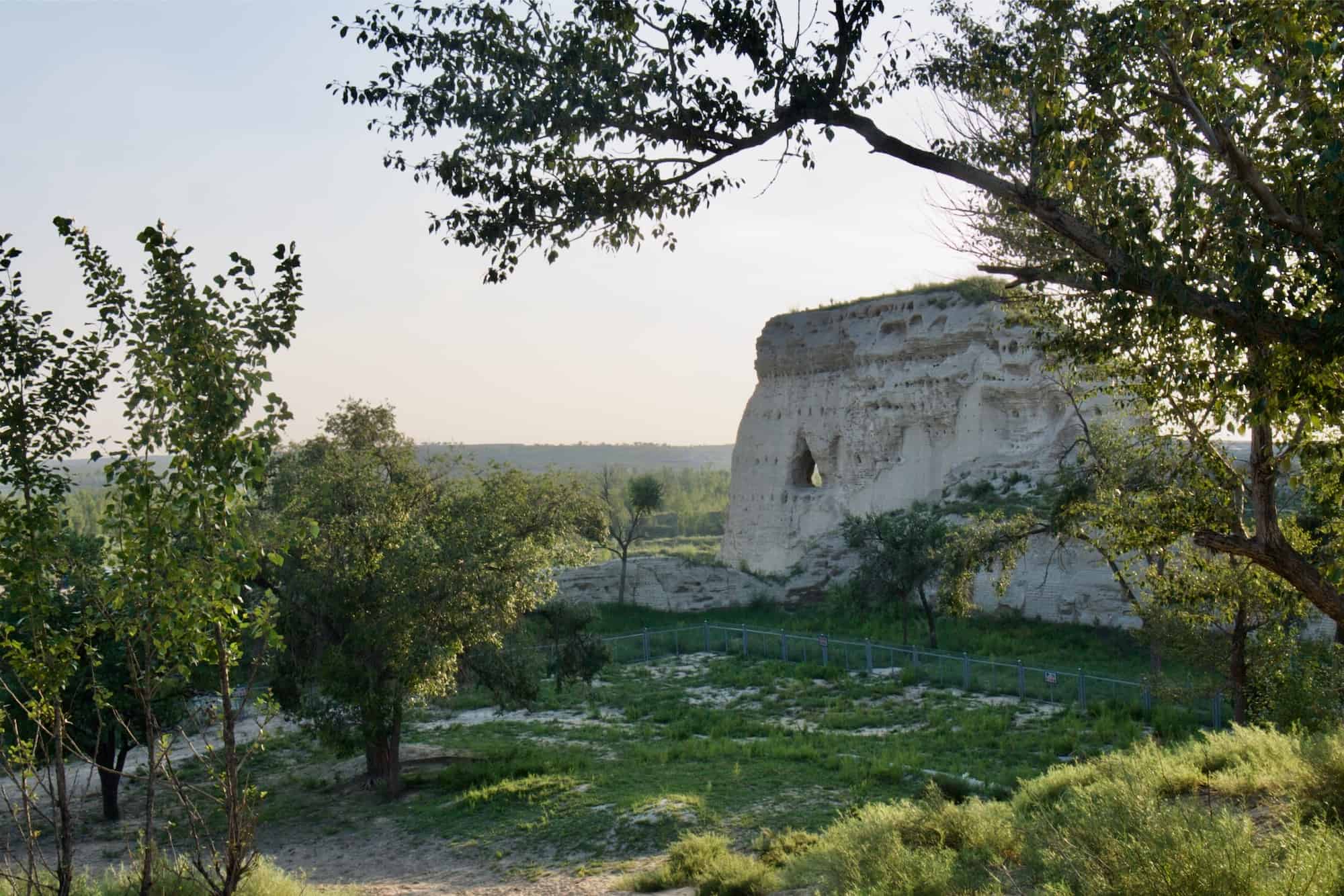
Today, the palace area contains the most impressive display of ruins, and probably is the most recognizable section of Tongwancheng. At the western corner are the remains of a multi-story section of wall called Chang’an Tower. This section once barricaded the palace area and served as the primary watchtower on the route south toward Chang’an (Xi’an).
The wall of Chang’an Tower is riddled with odd-looking holes that almost appear as windows from a distance. However, these are actually where wooden beams were once held, but these have long since rotted away.
Tongwancheng’s Inner City

Running out of the southern end of the Palace Area is Tongwancheng’s southwestern wall. This is the most complete section of the remaining city wall and still contains high defensive bastions evenly spaced along its exterior.
Tongwancheng’s inner city is where most of the political and religious leaders, as well as the upper class would have lived. There are cavernous dwellings built into the inner sides of the city walls that were likely to have served as their homes.
Although several other sections of Tongwancheng’s city wall remain, none are as impressive as the southwestern wall. Inside the walls, much of the landscape looks as barren as the surrounding desert, with only a few traces of the other white walls in the distance.

It’s important to remember that, despite what the city wall and even structures built into it might lead you to believe, Tongwancheng was primarily built from wood and other perishable materials. These wooden homes have long since rotted away, just like the wood that would have been in the
There are also many remnants of the city’s more permanent structures made of distinctive white-clay mud bricks. Although many of these still remain to be excavated, there are some ruins also above ground, giving some sense of what these structures may have looked like.
Tongwancheng’s Outer City
The boundaries of the outer city are not clearly marked onsite by either ruins or modern signs, and none of the literature I have found references an exact location. The closest clue I have been able to find to the location of the main outer city is the satellite image of Tongwancheng — which leads me to think the main center of the outer city was located outside the southeastern wall.

This area between Tongwancheng’s southeastern wall and the Wuding River shows different features than the surrounding landscape, and it would make sense to have the city’s agricultural center near one of its main rivers.
Add to that, the most formidable defensive towers were built (or at least still exist) along the western city walls to protect the trade route to Chang’an (modern Xi’an), it’s less likely that the same amount of land would be available on Tongwancheng’s southwestern side for habitation and agriculture.
This seems to be backed up by signs
Although, it may very well be that the outer city completely surrounded the walled city of Tongwancheng.
My Visit to Tongwancheng

A decent amount of historical information on the ancient city of Tongwancheng exists, however, there is very little in English on travel there. Even when visiting with Ida, a native Chinese speaker from Sichuan, we couldn’t find any specific information prior to travelling to the area.
Our excursion began when we arrived in Jingbian, the closest sizable town to the Tongwancheng archaeological site. However, even that is a little generous. Historically, Jingbian was an outpost along the Great Wall and is now a crossroads between larger cities like Xi’an and Yinchuan.
It took a lot of asking around to find the best way to get to Tongwancheng. However, we finally got some limited information from the hotel reception.
The Bus Ride from Jingbian to Tongwancheng
Outside the doors of the main bus station, (located in the southwest) there were a number of touts and even pushy taxi drivers who offered to take us to Tongwancheng. We didn’t ask their price, but the hotel reception estimated about 300 RMB (US$45) to take a taxi there round trip. This would certainly be the easiest way to go.
And, looking back, that is probably the way we should have gone. It would have avoided a long debacle of fearing we had no way back.

From the town’s main bus transport station, we asked around until we found the local bus to Baichengzi (白城子), the nearest settlement to Tongwancheng (which it also derived its name from). While waiting for the bus to depart, I became a bit of a novelty to the other passengers who all began taking pictures of me, one even sitting on my lap while some horrid breath seeped through his large smile.
They told us that it’s best to stay on the bus until it leaves because the drivers try to avoid going all the way to the end of their route, where Tongwancheng is. Unfortunately, due in part to the region having a completely different Chinese dialect, and amplified by the fact that we were on a local bus headed into the remote countryside, even Ida wasn’t able to understand most of what they were trying to tell her.

Along the way, several English signs pointed the rough path to Tongwancheng along the bus route. In all, the bus ride took us about 2 hours.
Arriving at Tongwangcheng
Once the bus let us off at the entrance gate, we were waved into a small concrete home containing three beds and four people sharing a meal of noodles. Here, an old man sold us tickets for 30 RMB (USD 5) each.
From the ticket house, there is a brick-lined road about 1km to the ruins of Tongwancheng. As it begins curving up the hill, you are treated to a spectacular view of the surrounding landscape. Very soon after, the palace and fortifications of Tongwancheng begin to come into view.

Staring at our first clear view of the palace ruins, its scale was unclear. Was it closer than it appeared or exceptionally large and far away? The latter was true.
Then the most disappointing part came into view: the fence. In all the pictures I had seen of Tongwancheng, the site was without any barriers and there was the occasional person who had climbed up for the Indiana Jones-esque pose. The most recent of these was from 2013. It now appeared that the entirety of the ruins had a newly-installed grey fence around them. This fence prevented anyone from getting more than 1-2 meters from any of the Tongwancheng ruins.
This is an entirely understandable move. These ruins, along with many in the region, are made of mostly clay and mud, meaning they break and erode away very easily after so much time. Understandable, but still disappointing that we couldn’t get up close. I found out later via a conversion on Instagram that the fences had been erected within only the past few months.
Entering the Inner City of Tongwancheng

The area where we were standing, looking at the Chang’an Tower and southwestern wall, also contained the archaeological site’s main parking lot. To enter the ancient city, we had to walk toward the far northwestern end of the parking lot and follow a trail around the Chang’an Tower into the inner city.
The same metal fence ran the entire length of this sandy trail, preventing any entrance before the designated point. This trail was littered with broken pieces of ceramic, likely roofing tiles from the color and relative flatness of them. Meanwhile, the entire hike down the trail, it seemed we were getting no closer to the large northern defensive tower that we were walking toward.


There was actually very little inside the city wall that we could tell upon first entering. The entire inner city was grown over with unkempt grass and weeds. Wandering around a bit, there were the eroded ruins of some other white structure. Some of them still built up enough to guess what they might have been, while others were indistinguishable from the natural whitish landscape.
That proved to be one of my major issues while touring the ancient city: there was no onsite documentation or informational signs explaining anything. This might very well have changed since my visit, but at that time, we had no idea of what we were looking at most of the time.
In an area near the center of the inner city, we found one excavation pit with someone actively doing work inside. We tried to talk to him, but encountered the same language barrier that we had on the bus — Ida could not understand the local dialect and this excavator didn’t know Mandarin — although this was to a lesser degree this time.

In a few sections, including near the Palace Area/Chang’an Tower and along the far eastern walls, were several chambers built into the city wall, their dark entrances obvious against the white mudbrick. However, we did not get the chance to enter these. The chambers near the palace were fenced off and the ones in the easter walls were too far off by the time we noticed them, and it was starting to get late … and we were stranded, as it turned out.
Hitchhiking Back from Tongwancheng to Jingbian
Not really knowing what to expect from the trip, we had not left Jingbian until around 2pm. Adding in the 2-hour bus ride, we did not arrive at Tongwancheng until 4pm.
Come 5:30, the sun was beginning to set and we were still inside the city walls. Being the vast area it was and terrain not so easily hiked through quickly, we needed a good head start to beat the sundown in the parking lot.

Something we didn’t expect was the mosquitoes. As soon as the air started to cool slightly, we were surrounded by swarms of mosquitoes like I had never experienced in recent memory. And these were very large ones, too. Needless to say, that sped up our hike back to the parking lot.
However, when we returned to the parking lot, we found it empty, less one large van. When we arrived, there had been a decent amount of people and at least a quarter-full parking lot. Now, there was no one. A few moments later back at the ticket booth, we found the same, and no indication that another bus would be coming back.
Now without any idea of how to get back to Jingbian, Ida and I simply looked around for anyone nearby that could provide information. Back in the parking lot, we found the owners of the van, 4 or 5 men, heading out of the ruins.
How we missed them before is something I’m still not sure about, but we began to ask them if they knew anything about the bus back to Jingbian. It turned out they weren’t local, but members of the Shaanxi provincial government from Xi’an who were surveying Tongwancheng for further development (AKA, adding in all that information I said was missing earlier).
They did not know any information about the bus schedule, but offered to take us as far as they could back toward Jingbian. At this point, we gladly accepted without hesitation, and, while I was oblivious to most of the conversation happening during the ride without Ida’s translation, those fragments I did get involved in were both interesting and genuinely friendly.
We rode the vast majority of the way back with these government officials, but they had to take a different road back to Xi’an than we were taking to Jingbian. They dropped us off at a major intersection where they told us we’d be most likely to find either a bus or ride into town.
Not too long after, the large, bald white guy caught someone’s attention and we were picked up by a local headed into Jingbian. Once again, the larger conversation was lost on me, but not his hospitality. He wanted not just to take us back to town, but treat us to dinner.
By the time we were rolling into the outskirts of Jingbian, it was already dark and Ida and I did not want to trouble this kind man any further. We politely rejected his offer and got dinner on our own at the edge of the town.
How to Get to Tongwancheng
GPS Coordinates: 37.99873, 108.84743
The easiest place from which to access Tongwancheng is the town of Jingbian, a crossroads town in the north of Shaanxi Province. To reach Tongwancheng, you need to take a local bus north from Jingbian. However, these local buses are located in a different area of town than the train station or intercity, long-distance bus station where you will arrive.


The local buses leave from the “Old Bus Station”, a small area in the northwest of town on a street called Beixinjie (北新街). The buses leaving to Tongwancheng are labeled with: 靖边 – 白城则村 (Jingbian – Baichengzi Village) and the entire one-way ride takes approximately 2 hours.
It’s important to note, and was explicitly told to us by locals, that Tongwancheng is the very last stop on this bus route — and that most drivers will try to avoid going out this far. This would seem to make the bus schedule to return to Jingbian from Tongwancheng unpredictable.
Alternatively, there are private taxis that will take you to the ruins for approximately 300 RMB (USD 45). There are people that will approach you about this right outside the doors of Jingbian’s long-distance bus station, but it would be better to book a driver or taxi through your hotel.
This will provide at least a small level of reliability and safety that you won’t get by going with the first guy you see outside the bus station. While I have never heard of the areas around Jingbian and Tongwancheng being dangerous, they are extremely remote. Any extra safety precautions are always advisable.
Fast Facts
Fast Facts
Name: Tongwancheng
Where: Jingbian, Shaanxi, China
Location: 37.99873, 108.84743
Description: Tongwancheng is a walled city built by the nomadic Xiongnu (Huns) in 419 CE. Today this city sits in remote ruins at the southern edges of Inner Mongolia.
Getting there: From the old bus station in the northeast of the city, find the bus to Baichengzi (白城子). Take the bus for 15 RMB (USD 3) to the very end to be dropped off at the Entrance to Tongwancheng.
Cost: 30 RMB/person / 6 USD
Glossary
Han dynasty 汉朝
The ruling dynasty of China from 202 BCE – 220 CE. Han doctrine was characterized by economic prosperity through outside trade via the Silk Road creating the earliest sense of a single Chinese “Han” identity.
Hexi Corridor 河西走廊
A narrow geographic region between the Gobi Desert and the Tibetan Plateau in western China that was an important path on the Chinese end of the Silk Road. The Han dynasty secured and fortified the Hexi Corridor, allowing trade caravans to become more common.
Hu Xia dynasty 胡夏朝
Name given to the ruling dynasty (407-431 CE) by the Chinese to the settled Xiongnu (Huns) who inhabited Tongwancheng. Also known as the Da Xia (大夏), Northern Xia (北夏), and Helian Xia (赫連夏).
Inner Mongolia 内蒙古
Province in the north of China designated as an autonomous Mongolian region. The territory is made up primarily of steppe and the Gobi Desert.
Jurchen people
An ethnic group from Northeastern China that would later become known as Machus or Manchurians. They are most well known for forming the Jin (1115-1234 CE) and Qing (1636-1912 CE) dynasties.
Northern Wei dynasty 北魏
Ruling dynasty of Northern China (386-534 CE) established by the Xianbei people. The Northern Wei rulers were responsible for commissioning many of the famous rock-cut Buddhist temples in Northern China.
Shaanxi 陕西
Province in northern China that has historically served as the capital and heartland of most of China’s dynasties.
Silk Road
A vast trade network connecting China to India, the Middle East, and Europe through Central Asia that was responsible for the intercultural spread of goods and ideas. Although trade began along these routes prior to the Qin dynasty, it began flourishing during the Han dynasty when they secured the Hexi Corridor.
Xiongnu 匈奴
Nomadic ethnic group originating from the steppes along the northwestern border of China, and presumed to be the ancestors of the Huns. The Xiongnu raided the Chinese borders and trade routes along the early Silk Road.
Sources
- Sygic Travel: Tongwancheng
- ResearchGate: Tongwancheng// the city of Southern Huns
- China.org: Ancient Hun Capital Registered for World Cultural Site
- https://www.heritagedaily.com/2021/02/tongwancheng-capital-of-the-xia-kingdom/137113
- http://www.transoxiana.org/14/obrusanszky_tongwan_city.html
- https://www.theapricity.com/forum/showthread.php?51256-Tongwancheng-The-Ancient-Capital-Of-The-Huns
- http://en.people.cn/n/2014/1120/c204459-8811942-3.html
- https://www.researchgate.net/publication/327048000_Silk_Road_Influences_on_the_Art_of_Seals_A_Study_of_the_Song_Yuan_Huaya/fulltext/5b74e48e299bf14c6da8b1cd/Silk-Road-Influences-on-the-Art-of-Seals-A-Study-of-the-Song-Yuan-Huaya.pdf
- Wikipedia: Xiongnu
- Wikipedia: Xia (Kingdom)
- Wikipedia: Northern Wei


