Archaeological travel guide to the Lanna-Sukhothai Border Wall, an ancient ruined wall marking the historic boundary between the two early Thai Kingdoms.

The idea of border walls to mark territory is nothing new. Whether it’s a simple line of stones marking that a boundary exists or a massive fortified barrier to defend against invading forces, examples of border walls can be found all throughout the ancient world, including, apparently, in Thailand.
The Lanna-Sukhothai Border Wall is a ruined brick wall in the style of ancient Thai city walls located in southern Lampang Province. This fortification was built at the northern boundary of the Sukhothai Kingdom with slopes facing southward, indicating it was manned by soldiers from Sukhothai, not from Lanna.
Today, the ruined wall is located in a dense forest at the modern border of Thailand’s Lampang and Sukhothai provinces. It is not publicized in English or Thai literature, nor is it even marked or acknowledged as a historic site locally, making it all the more fun to track down.
Contents
The Story of the Lanna-Sukhothai Border Wall

Located in the quiet forests at the border of modern Lampang and Sukhothai provinces is an ancient brick wall wedged between two low mountains. This leftover relic is over 500 years old and is meant to mark the historic boundary between Thailand’s Lanna Kingdom and Sukhothai Kingdom.
The gate itself lies at the foot of the Phi Pan Nam Mountain Range, one of the southern borders of Thailand’s northern highlands, which the Lanna Kingdom historically dominated from Chiang Mai. Below these hills, there are still sparse rocky outcroppings, however, they are surrounded by the flatlands that host the fertile river plains that make up the Central Region of Thailand, where Sukhothai, and later Ayutthaya, would flourish.
To date, no official information is available on this wall. However, its proximity to Sukhothai, combined with the fact that an artificial incline exists on the southern side of the wall, suggests that it was constructed by the Sukhothai Kingdom rather than by Lanna (ancient Chiang Mai).
However, being that there is no academic information on the wall, it might be that it was built during the century of conflict between Lanna and Ayutthaya. Either possibility might hold merit until more information and research is available.
The Relationship Between the Lanna and Sukhothai Kingdoms
Lanna and Sukhothai are two of the earliest Thai kingdoms to establish themselves in the 1200s CE within the modern borders of Thailand. Another was the Phayao Kingdom, which would later be absorbed into Lanna.

In the 1290s CE, as Mangrai, the King of Lanna, was establishing his new kingdom, he invited his counterparts, Ramkhamhaeng of Sukhothai and Ngam Muang of Phayao, to the Lanna capital at Chiang Mai for counsel in establishing his new city and to form an alliance. This Thai alliance was in large part to defend their kingdoms against the Mongols and Yuan Dynasty to the north. By this time, the Mongols had decimated the Nanzhao and Pagan Kingdoms, warred with Angkor, and had been a driving force in the migration of the Tai peoples from southern China.
Throughout their existence, each kingdom expanded its influence. Lanna was based in the Thai northern highlands, and used rivers and mountain passes to inhabit the valleys in the north. Meanwhile, the Sukhothai Kingdom was based in the northern reaches of Thailand’s Central Plains and spread its influence southward.
The Fall of Sukhothai and the Lanna-Ayutthaya Wars
Main article: Cultural Profile: Ayutthaya Kingdom, the Buddhist State of Siam
Beginning in the mid-1300s, Sukhothai’s strength was beginning to wane and many of its outer provinces began to break away. This allowed for the city of Ayutthaya to begin growing in influence, and eventually replace Sukhothai as the ruler of Thailand’s Central Plains. As territories fell out of Sukhothai’s grasp, Lanna and Ayutthaya began competing for them, eventually bringing them into conflict.
By 1378, Sukhothai had lost its independence and by 1438, the city had become a province of Ayutthaya, and the Sukhothai Kingdom’s former cities began serving as bases from which Ayutthaya launched military campaigns against Lanna. These wars went on for the rest of the 15th Century, however, neither side gained or lost much territory.
While these wars did not do much to change the status quo between Lanna and Ayutthaya, the sole remaining Thai kingdoms, they did serve to weaken them both. In the following decades, they would both fall victim to a rejuvenated Burmese kingdom.
My Visit to the Lanna-Sukhothai Border Wall

This wall became something of an ongoing mystery to me over the course of the year. I first saw photos of it on the feed of a Thai history group on Facebook. Photos of a thick brick wall that were reminiscent of the city fortifications of Lanna cities including Chiang Mai, Lamphun, or Chiang Saen, something much more imposing than would be placed around a religious structure as a boundary wall.
Even more intriguing was that it was in the middle of the forest. I have seen a lot of city walls in northern Thailand, but had never seen a brick one in the middle of the forest. However, no one could elaborate more on this wall. There was a comment in Thai that (when translated) said that it was located in a particular region along the border of Lampang and Sukhothai provinces, but that is still a large area.

Eventually, I narrowed it down to the border region of Mae Mok, Lampang Province and Thung Saliam, Sukhothai Province. However, there is no information about any archaeological site in the region. Even photos on Google Maps in the area turned up nothing. Eventually, the only way to find out more was to get there myself.
Arriving in Thung Saliam

The drive from Chiang Mai to Thung Saliam was a pleasant, if long, one. In the final stretch, as the mountains give way to the plains, there is a final wall of natural karst outcroppings that would make a great natural border marker in itself.
There are a handful of hotels out in the rice fields surrounding the town of Thung Saliam, and the town itself seems to have a lovely night market around its main temples. Otherwise, the main attraction is just the natural scenery.
After we checked into the hotel, I was off down the road to Ban Ho Rob, to look for some sign of the wall.
The Village of Ban Ho Rob

While Thung Saliam is fairly typical of a small Thai town probably growing off of the highway passing through to Sukhothai city, Ban Ho Rob is unarguably a more historic village. It is connected to the highway, but sits well off the main road and clustered closely around its own single-lane streets.
Passing through to the opposite end of the town brought me to a dirt road leading off into the rice fields. These kinds of roads have landed me in some trouble with cars before, so I wasn’t going to take it any further than the road would allow. About 1km down the dirt road, it got to that point and I pulled the small Nissan March along the edge of the road and proceeded to walk.
The Hike to the Lanna-Sukhothai Border Wall

As far as countryside hikes go, this one wasn’t bad. However, there are no clear markers, leading to what I was looking for. As the road began to enter forested hills that line the karst outcroppings, I had the choice of going left or right. Left would keep me going in the direction of Thung Saliam, going right would lead me away.
Taking the left path, I continued down the road for about 400 more meters through much denser forest, until the wall finally came into view. I honestly had no idea what to expect, if this would be simply a city gate, a small section of wall, or part of a kilometer-long construction that went unpublicized.


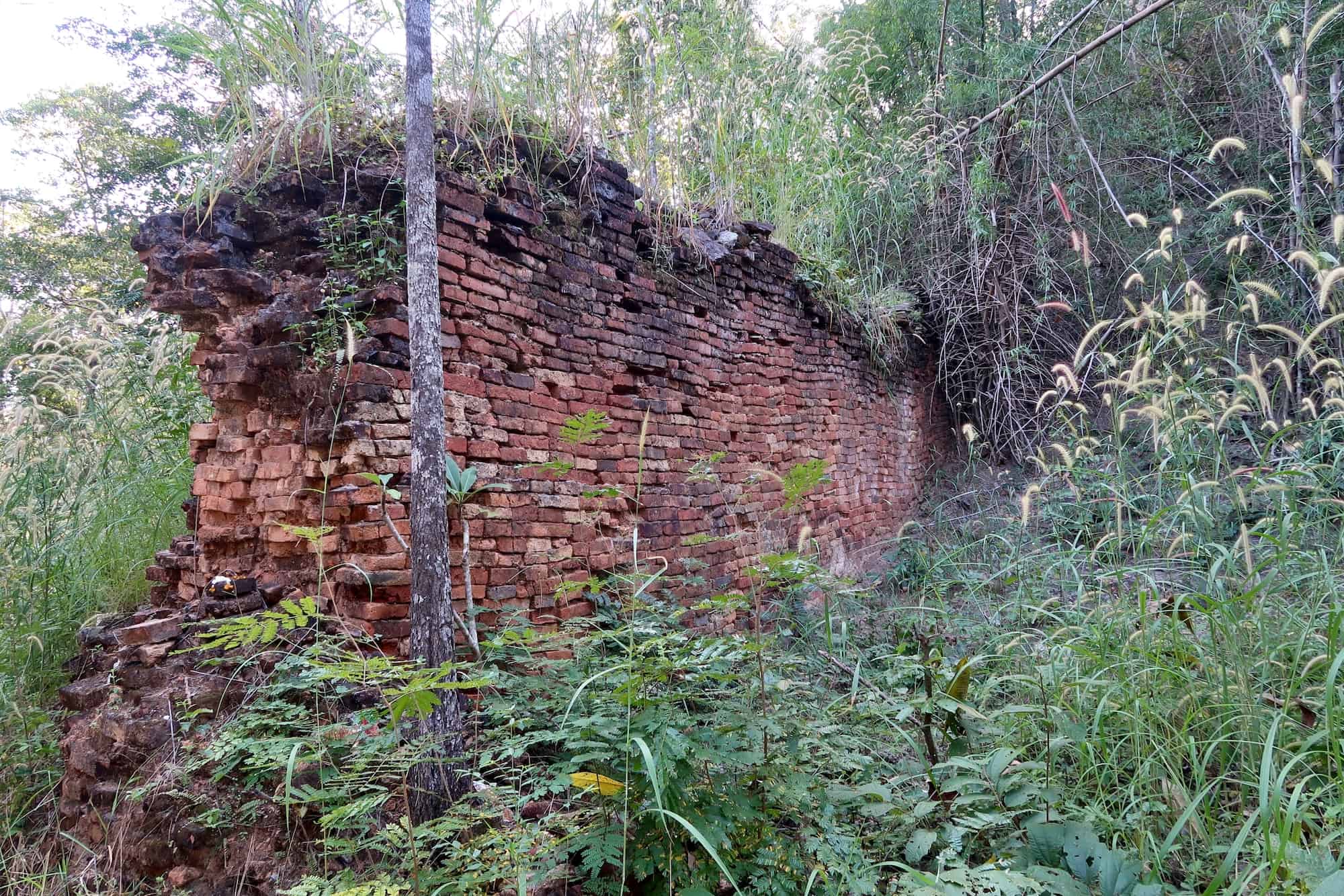
The Lanna-Sukhothai Border Wall I ended up finding was about 30-50 meters long, 1 meter wide, and 5-meters tall stretch of brick wall that is wedged into the narrow pass between two low, dome-shaped mountains.
The wall has been broken into two sections in order to allow the modern gravel road to pass through, and there is no indication what sort of gate may have once existed here before. While this is unfortunate, it did provide an interesting cross-section of the central stretch of the wall from ground-level to the top, meaning a visitor can see the surprising hollow space in the interior, which was likely filled with dirt or other sediments in the past.

The entire construction is surrounded by very thick overgrown, some of which have taken root in the lower bricks themselves. While this will certainly cause further damage in the future, it didn’t seem to have yet.
The most interesting feature of the wall was the contrast between the two sides. The southern side, which faced Thung Saliam and Sukhothai Province (and therefore the former Sukhothai Kingdom), has an earthen slope leading a significant way up the side of the wall. At the base of this slope is a thick layer of intentionally placed rocks that are cemented together.


Meanwhile, the northern-facing side of the wall was smooth from ground level to the top, or at least as smooth as a 5-century-old wall can be. This was on the side of Ban Ho Rob, where I had come from, and the side that faced the Phi Pan Nam Mountains and the former territory of the Lanna Kingdom.
So what can be gleaned from that small detail?


The slope was a platform intentionally placed on the Sukhothai side of the wall, allowing personnel on that side of the wall easy access to view over the top. On the Lanna side, the sheer, smooth height of the wall was nothing but a barrier.
This leads to the conclusion that the wall was built by whoever occupied the southern end of the wall, presumably the Sukhothai Kingdom, but possibly the later Ayutthaya Kingdom. However, it would have been unlikely to have been a project made by the Lanna Kingdom.
Following my visit to the Lanna-Sukhothai Border Wall, we made it a point to enjoy the few attractions Thung Saliam has to offer. This included the modest night market, which is notably the highlight of the town’s social events — cars were parked a block away to get there.

This was followed by dinner at a great restaurant overlooking the sunset on the Phi Pan Nam Mountains, quite symbolic of one of my last excursions trying to track down the remains of the Lanna Kingdom.
How to Get to the Lanna-Sukhothai Border Wall
GPS Coordinates: 17.33163, 99.47022

Although the Lanna-Sukhothai Border Wall is located in Lampang Province (along the border with Sukhothai Province), it is more easily approached from Sukhothai Province. Any approach from Lampang will involve a long and complicated drive through the Phi Pan Nam Mountains on Highway 1048, but the approach from Sukhothai is all flat.
The closest town of any significance and that will have hotels is Thung Saliam. Although remote, the town is large enough that buses, or at least vans, are likely to have schedules passing through Thung Saliam from the bus station in the provincial capital, Sukhothai City. However, once in Thung Saliem, there is not likely to be any public transportation available to get Ban Ho Rob or to the ruins.
With your own private transportation, it is a 10-minute drive between Thung Saliam and Ban Ho Rob. The ruins themselves are not in the town of Ban Ho Rob, but on a dirt road leading out to the south. The road is rough and not recommended for small cars. I drove about 1km back and had to park the car in order to walk for the final kilometer.
When you come to a fork in the road leading into the forested hills, take the left road, which will lead you to the wall in about 400 meters.
Fast Facts
Fast Facts
Name: Lanna-Sukhothai Border Wall
Where: Ban Ho Rob, Lampang, Thailand
Location: 17.33163, 99.47022
Description: The Lanna-Sukhothai Border Wall is a ruined brick wall between two low-lying mountains that marked the border between the two early Thai kingdoms.
Getting there: Private transportation is needed to reach Ban Ho Rob and the ruined wall, which is several kilometers from the main road.
Cost: Free
Glossary
Ayutthaya Kingdom
Thai kingdom based in central Thailand, later referred to as Siam. Its capital was the city of Ayutthaya until the city was destroyed by the Burmese, forcing the state of Siam to relocate to modern Bangkok and found the Thonburi Kingdom in 1767.
Lampang
City in northern Thailand historically known as Khelang Nakhon. Founded by the Hariphunchai Kingdom to control the Wang River Basin, the city was later absorbed by the Lanna Kingdom.
Lanna Kingdom
Thai kingdom based in northern Thailand and northwestern Laos. Its capitals included Chiang Rai, Wiang Kum Kam, and Chiang Mai.
Phayao
City in northern Thailand and historic center of the Phayao Kingdom before becoming part of the Lanna Kingdom.
Phi Pan Nam Range
Small mountain range between Lampang and Sukhothai provinces in Thailand.
Ramkhamhaeng
Legendary king of Sukhothai who is popularly credited with creating the Thai writing system.
Sukhothai
City in central-northern Thailand and abandoned capital of the Sukhothai Kingdom.
Sukhothai Kingdom
Thai kingdom based in central-northern Thailand, after the overthrow of Khmer rules. Its capital was the city of Sukhothai, which was later conquered and absorbed by the Ayutthaya Empire.
Tai peoples
Ethnic group originating in Southern China that migrated south during the Mongol invasions, eventually founding the kingdoms hat became Thailand and Laos.


Great discovery Ben! Now on my to do photography list.
Beautiful area with the karst mountains around, too. I hope you enjoy it!
Love reading your post its full of knowledge and i appreciate the way you written .. Keep writing such article for gaining our knowledge
Thanks for commenting. I’m glad you’re enjoying it.