Historical travel guide to the Guiob Church Ruins, a colonial Spanish church on Camiguin, which miraculously survived the 1871 volcanic eruption that destroyed the the Philippine island’s capital.

Fast Facts
Name: Guiob Church Ruins
Where: Catarman, Camiguin, Philippines
Location: 9.20192, 124.63469
Description: The Guiob church is a ruined colonial Spanish church that survived Camiguin island’s devastating volcanic eruption in 1871, which wipe out the island’s entire capital.
Getting there: Both the Guiob Church Ruins and the Sunken Cemetery are located on Camiguin’s main Circumferential Road, about 13 kilometers from the airport, and can be reach by any of the island’s local transportation.
Cost: Free
In the Philippines, a nation renowned for beautiful and tranquil islands, Camiguin is one of the less frequented destinations. This in itself gives the island a kind of low-key atmosphere when visiting. Between the island’s array of ornate ancestral houses, its sunken cemeteries, or the haunting church ruins created by a volcanic eruption, the history of Camiguin is its real draw.
On May 13, 1871, Camiguin’s Mt, Vulcan volcano erupted, destroying the island’s capital and sinking a large port of the island into the ocean. The only remnants of the former capital are the ruined Guiob Church, still revered by locals as surviving due to the grace of God.
The Story of the Camiguin’s Guiob Church Ruins
Camiguin is a volcanic island made up of several tectonically active peaks. The highest and most prominent of these is the Hibok-Hibok Volcano located in the center of the island. This scenic peak can be seen towering over the Camiguin’s horizon from many points around the island.
However, it was another volcanic peak, Mt. Vulcan, that caused the greatest disaster in Camiguin’s recorded history.

Camiguin’s Volcanic Eruption of 1871
Although the Camiguin’s northern, Mambajao, is the modern capital and commercial center, this position once belonged to the western town of Catarman. This was the main center of Spanish influence and home to the former capital of Camiguin, then known as Cotta Bato.
As early as February of 1871, Camiguin began experiencing earthquakes. These only increased in intensity over the next few weeks. Eventually, this culminated in a fiery eruption that burned away and submerged the entire town of Cotta Bato, burying it beneath the Pacific waters off of Camiguin’s Western coast.

Cotta Bato was but a dreadful pile of ruins. The single volcanic eruption buried the beautiful town into obscurity.
Memorial plaque at the Guiob Church Ruins
Hundreds of lives were lost while the survivors sought refuge in the open country that gave them hope for tomorrow.
Early Accounts of Camiguin Island
Camiguin has long been on the radar of European colonists, with records of it appearing as far back as Magellan’s legendary voyage. Magellan’s visit is recorded on April 3, 1521, where his crew landed on what they considered a deserted island. They replenished their water supply and continued on.
In 1563, the Portuguese raided many of the islands in the area, including Camiguin. During this period, they burned the villages of the islands and killed many of the locals. Two years later, the Spanish led by Miguel Lopez de Legazpi arrived at Camiguin to find the local villages abruptly deserted. The local inhabitants had seen the ships and feared the return of the Portuguese from 2 years before.

Camiguin was subsequently the first island settled by the Spanish in the Mindanao group (the southern islands of the Philippines). During this time, they began searching for valuable trade goods and the process of converting the local population to Christianity – a pattern that would continue to repeat itself through the entire Philippine archipelago.
Christian History on Camiguin Island

The earliest account of Christianity on Camiguin was during the Portuguese voyage of Francisco de Castro in 1538. He is recorded to have sailed between several islands in Mindanao, attempting to convert the locals to Catholicism. One of the converts was recorded as the “king of Camiguin”, who was later dubbed Don Francisco. This conversion involved the baptism of the king, his family, and all his subjects. Whether this included the entire population of the island is unclear.
In 1596, Jesuit missionaries received permission from the Spanish governor of Mindanao to proceed with their work. They founded the town of Guinsiliban in 1599 to use as their base. Guinsiliban was shortly abandoned by the Jesuits, apparently suffering several hardships including less-than-enthusiastic natives on Camiguin.
In 1622, the order of Recollects arrived on Camiguin and founded the town of Catarman on the western coast. This group would remain on the island for over 200 years working to convert the locals to Christianity. During this time, they founded other towns on Camiguin, including the current capital Mambajao.
It was these Recollect Missionaries who ran the church that would later be destroyed by the Mt. Vulcan eruption, along with the entire surrounding town.

Visiting the Camiguin Guiob Church Ruins
In the search for ruins and notable archaeological sites throughout the Philippines, there is much less than I would have expected given their prominence in the nearby islands of Indonesia. Most ruined historical architecture that does exist is post-European contact. However, I had a week to spare in the Philippines and felt like a quiet getaway with some history involved — so the volcanic ruins of Camiguin won out.
The island is small enough to ride a motorbike around in a few hours, so that was the approach I took. Hopping on my pink motorbike rented from the owner of my hotel, I opted for a counterclockwise route around the Camiguin Circumferential Road (not-so-catchy name, but accurate).
On the Road in Camiguin

While a little rough at times, the Circumferential Road is easy enough to drive. Starting from my hotel on the north end of the island, it was not too long before I was passing the signs pointing out the walkway to the top of the volcano.
At the time, I was unfamiliar with the fact that there were multiple volcanic peaks making up Camiguin, and was not in the mood to hike to what I thought might be the center of the island so I kept going.

The Sunken Cemetery of Camiguin
Along with the sunken town, an entire section of western Camiguin was submerged underneath the Pacific Ocean during the 1871 seismic disaster. This small peninsula can still be seen on satellite images as a shallow area along Camiguin’s western coast.
The event is memorialized by the island’s Sunken Cemetery, a large white crucifix standing atop an artificial platform about 100 meters out into the ocean.
Despite there being signs for the Camiguin Sunken Cemetery, it is easily passed by if you don’t recognize the significance of the monument. Along the roadside, is a walkway two the ocean, where you can view the memorial, and even hire a boat to ride out to the monument’s platform.

I opted against the latter, instead admiring it from the coast.
Arriving at the Ruined Camiguin Church
A half kilometer down the road from Camiguin’s Sunken Cemetery is the Guiob Church Ruins (alternative known as the Old Spanish Church). At first, I entirely missed the entrance until I saw what seemed like ruins on a ridge standing above the road behind a gate.

Pulling back around, I parked the pink motorbike and entered the site. The entrance had more signs warning of proper behavior in the site than about itself — among these, deterrents against smoking, littering, plastics, and more.
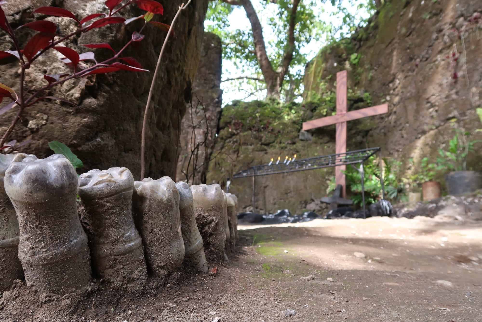
Past the main gate, you’re immediately at the walls of the ruined church. There are 3 main buildings making up the site, the largest of which is the first you’ll enter. Its front wall is landscaped with recycled plastic coca-cola bottles, and the interior consists of a single, large open room. This was very obviously the main chapel, although all of the wooden furniture and decoration that would have traditionally adorned it had long since vanished, whether from burning in the eruption or simply rotting away with time.


The entire church was curiously made out of coral, which has all been seared together from the extreme heat of the volcanic eruption over a century ago. Despite this, you can still make out the individual shells and other coral life. Particularly interesting were the sections of brain corals that were clearly visible through many parts of the church walls.
Unfortunately, save one informational plaque at the entrance describing the events of the eruption (rather poetically) there are no other informational displays around the ruins. So, while the purpose of the main chapel was easy enough to figure out, I was still unsure what the other two smaller buildings were. They are very obviously part of the same complex — being built of the same coral materials and suffering identical damage.


Further research identified these two buildings as the church’s rectory and a watchtower.
While exploring the two smaller buildings, two children began peeking around corners trying to see what I was up to. They were carrying wicker brooms and seemed to be the children of one of the Guiob Church’s groundskeepers. Getting a few smiles and laughs out of them mad for a pleasant way to wind down my first glimpse into the ruins the Philippines had to offer.

How to Get to the Camiguin Guiob Church Ruins
GPS Coordinates: 9.20192, 124.63469

Most visitors in Camiguin will begin in Mambajao, the island’s capital and largest town along the northern coast, which also hosts the Camiguin Airport. From here, there will be island taxis either private tuk-tuks (called tricycles locally) or multicabs (small van-pickup truck hybrids), where you jump in the back and continue along the road to your destination.
Alternatively, and more enjoyably, many shops and hotels will rent private motorbikes. Although most of the roads in Camiguin aren’t too difficult to drive, do ensure that you have some familiarity with how the motorbikes operate and always be vigilant when driving.
Fast Facts
Fast Facts
Name: Guiob Church Ruins
Where: Catarman, Camiguin, Philippines
Location: 9.20192, 124.63469
Description: The Guiob church is a ruined colonial Spanish church that survived Camiguin island’s devastating volcanic eruption in 1871, which wipe out the island’s entire capital.
Getting there: Both the Guiob Church Ruins and the Sunken Cemetery are located on Camiguin’s main Circumferential Road, about 13 kilometers from the airport, and can be reach by any of the island’s local transportation.
Cost: Free
Glossary
ancestral houses
Large, intricately decorated wooden houses that housed multiple generations on Camiguin island.
Camiguin
Volcanic island in the Mindanao group of the Philippines.
Jesuits
Catholic order of Christian monks who engaged in educational and missionary works during colonial times.
Mindanao
The southern island group of the Philippines
Recollects
French order of Franciscan Christian monks who took a vow of poverty to pursue a life of spiritual reflection.
rectory
The residential building provided by a church for its minister or priest.
Roman Catholic Church
The largest branch of Christianity, established in the 3rd-4th Century CE and based in Vatican City.
Sources
- Demetrio, Francisco R., and Vicente Elio y Sanchez. “The History of Camiguin: Vicente Elio y Sanchez (1863-1938).” Philippine Studies, vol. 20, no. 1, 1972, pp. 106–146. JSTOR, www.jstor.org/stable/42634822. Accessed 16 Sept. 2020.
- Neri, Leee Anthony M., et al. “Archaeological Survey of the Island of Camiguin, Northern Mindanao.” Philippine Quarterly of Culture and Society, vol. 38, no. 3, 2010, pp. 231–257. JSTOR, www.jstor.org/stable/41762431. Accessed 18 Sept. 2020.


