Archaeological travel guide to the best-kept secret temples and ruins in Chiang Mai, Thailand’s historic capital of the Lanna Kingdom.

For nearly 600 years, the Lanna Kingdom based their entire culture from Chiang Mai. To this day, this fortified city hosts a visual legacy of its long history scattered throughout the area. While a good portion of the city’s ruins and other historic sites are contained within the Chiang Mai Old City, many others are well outside its walls.
In a previous post, we looked at the 5 most impressive and monumental ruins Chiang Mai has to offer. This time around, let’s examine, say…, 11 ruins that you’ll almost never hear about without seeking them out.
Contents
Secret Island Temple | Wat Klang Nam
GPS: 18.75649, 98.9514
Main article: Wat Klang Nam: Ancient Chiang Mai’s Secret Island Temple

Wat Klang Nam (“Temple in the Middle of Water”) is perhaps the most dramatic of the ruins on this list – as well as a personal favorite. The ruins feature the base of a full Lanna temple sitting on a small island in the middle of a lake on the south side of Chiang Mai. The entire scene is heightened by the dominating reflection of Doi Suthep throughout the lake.
The Wat Klang Nam island temple is located just south of Chiang Mai International Airport (CNX). It is in an area of the city only accessible by private vehicle and is currently inside a housing development named Serene Lake. Although this is a gated community, I have never been denied access to the interior road.

Once through the gate, turn left at the southern shore of the lake. You should be able to see Wat Klang Nam’s small isn’t in the distance. Additionally, there are the small ruins of another temple visible at the lake’s southwest corner.
Layered History in the Zoo | Wat Ku Din Khao
GPS: 18.80723, 98.94547

The Chiang Mai Zoo is laid out as a looping road passing through several geographical ‘regions’. Near the end of this loop and surrounded by the zoo’s elephant habitats is the temple of Wat Ku Din Khao. Wat Ku Din Khao is unique among the temples in Chiang Mai city, as it was first built by the Lanna Kingdom’s predecessors, the Dvaravati Hariphunchai Kingdom.
Additionally, there appears to have been some cooperation between the Mon inhabitants of Hariphunchai (Lamphun) and the region’s indigenous people, the Lawa, in order to build this temple. Wat Ku Din Khao is located just to the south of the Lawa walled city of Wiang Chet Lin.

While the base of Wat Ku Din Khao features large-sized bricks stylistically related to Hariphunchai construction and like those found at the ruins of San Ku temple atop Doi Pui, the upper layers of the temple were repurposed to make Wat Ku Din Khao into a later Lanna Buddhist monastery.
Forgotten to the Jungle | Wat Phrathat Saengchan
GPS: 18.78253, 98.94727
Main article: Chiang Mai’s Lost Jungle Ruins: Ancient Saengchan & Phra Non

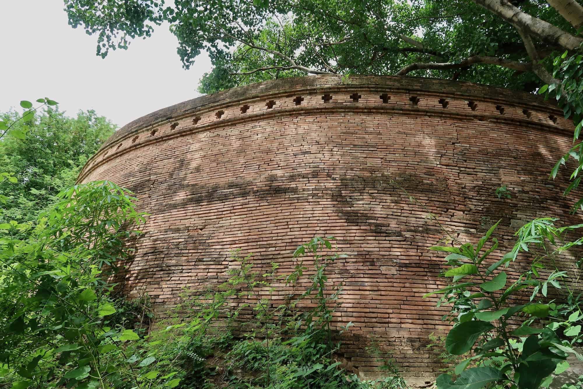
Ruined temples reclaimed by the jungle is one of the staples of the early adventure literature, and you have the chance to see these in Chiang Mai. A pair of temples – Wat Phathat Saengchan and Wat Phra Non – are 17th-Century temples sitting in the quiet overgrowth of the Doi Suthep forests. Of these two, Wat Phrathat Saengchan is the more extraordinary — it is built on a reinforced hilltop and hosts a large ruined stupa along with many sectioned-off rooms.
Both Wat Phrathat Saengchan and Wat Phra Non are inside the Choeng Doi Suthep Wildlife and Nature Education Center, a wildlife reserve on the dry western edge of Chiang Mai city in the foothills of Doi Suthep Mountain. The entrance is not far from the much more famous Wat Umong, although it is difficult to find. Any visitor will need private transportation, such as a bicycle or motorbike to reach the Choeng Doi Suthep Wildlife and Nature Education Center.
Also, be advised, the dirt roads through wildlife reserve are both rough and confusing. There were several areas where I couldn’t pass through even on a motorcycle and had to park to walk further. Likewise, there is little signage or indicator of where you are, and I got lost several times trying to find my way back to the entrance.
The Broken City Wall | Thipanet Bastion
GPS: 18.77621, 98.97787

The large brick city gate gates and fortifications are one of the staple charms of the Chiang Mai Old City. Although it’s disappointing that they are mostly reconstructions, there exists one very authentic brick fortification of Chiang Mai’s lesser-known outer city wall, the Kamphaeng Din (“land wall”). Most of the Kamphaeng Din wall was earthen fortifications, sometimes reinforced with brickwork. Examples of this can be seen along Kamphaengdin Road on the eastern side of the city between Thapae Road and Sridonchai Road, as well as in Kanchanaphisek Park.
However, the southwestern corner Kamphaeng Din is a fully-fortified brick platform called the Thipanet Bastion. This brick tower sits hidden between private homes in Chiang Mai’s Haiya neighborhood. Atop the Thipanet Bastion is a small shrine and recreation area.

The easiest way to access the Thipanet Bastion is off of Mahidol road, the busy highway leading south out of the Old City. There is only one 7-Eleven on this stretch of Mahidol Road heading toward the Central Airport Mall. To the right of the 7-Eleven is a small alleyway leading to a single-lane dirt road and bridge. About 10 meters back is a stairway leading up into the trees. Climb this and you’ll be atop the outer wall. Turn right to get to the Thipanet Bastion.
**Please be aware that the Thipanet Bastion is not a tourist attraction. You are in a residential neighborhood and likely to be trespassing on people’s properties if you happen to wander off the trail, which is easy to do. While I found the residents exceptionally tolerant and even amused by my presence there, some might not. Be courteous and do not go where you would be unwelcome. Furthermore, if asked to leave, do so.
Holy Outer City | Wiang Suan Dok City Wall
GPS: 18.79084, 98.96508
Main article: Wiang Suan Dok: Ancient Chiang Mai’s Holy Outer City

Perhaps the most interesting aspect of Thailand’s history is the intertwining of cultures and constructions found throughout the country. Dvaravati, Thai, Khmer, Lawa, and others all built, overlapped, and at times fought with each other. The walled city of Wiang Suan Dok (“Flower Garden Walled City”) is one such example very near the heart of Chiang Mai.
Wiang Suan Dok was originally a walled Lawa city that was abandoned before the Thais established their Lanna capital at Chiang Mai (which was also built over another ancient Lawa settlement called Wiang Nopburi). For a hundred years, the abandoned walled Lawa city sat empty outside the eastern gate of Chiang Mai, until the Lanna King Kuena invited the Sri Lankan monk Sumanathera to Chiang Mai. At this point, Sumanathera was gifted the remains of the ancient city, and Wat Suan Dok (“Flower Garden Temple”) was constructed in its center.
Today, Wat Suan Dok is a major attraction of Chiang Mai. It hosts a large open-air temple, as well as the Lanna Royal Cemetery. Not far away from the temple ground, you can still find many traces of the ancient walls of Wiang Suan Dok, one of which is bisected by Suthep Road. The best remaining section of the city wall can be seen if you follow this section back from the north side of the road, where it enters a part of the Chiang Mai University campus. Not far, you’ll find the northwest corner of the Wiang Suan Dok city wall, and a modern bridge leading over the wall from the academic buildings into campus gardens.
Highway Bypass Ruins | Wat Chang Phuak
GPS: 18.81111, 98.98358

Chiang Mai is ringed on 3 sides by multi-lane divided highways. Along the city’s north side is an area named Chang Phuak (“white elephant”) named after the northern city gate, and by extension, the coronation ritual Lanna’s first king undertook at that gate, involving a white elephant.
Just south of the divided highway is a ruined temple also named after this event, Wat Chang Phuak. While there are the remains of part of the temple’s worship hall, the ruins of Wat Chang Phuak also feature a well-preserved stupa hidden just out of sight from the highway in the parking lot of Chiang Mai’s “The North Biggest Computer Center”. This stupa features design elements not only from Lanna, but also Sukhothai styles, such as the bulging “lotus bud” design.
Backstreet Junkyard Stupa | Wat Lao Liang Chedi
GPS: 18.7773, 98.99057

Heading south from Chiang Mai Gate, one of the city’s 2 southern gates, Suriyawong Alley is lined with an impressive amount of ruined stupas and temples. A little farther off the road is one ruined stupa called Wat Lao Liang. There is no trace of the original worship hall, but the stupa itself is almost entirely intact, showing all of its features, less the original plastering.
While the stupa itself is in remarkable condition, the same cannot be said about the grounds surrounding it. Every time I have driven past this stupa, it has consistently been used as a makeshift garbage dump, with trash of all sorts surrounding the base. Unlike many other ruined temples scattered around the city, it seems there is, unfortunately, little-to-no effort put into the preservation of Wat Lao Liang
Sunken Swamp Temple | Unnamed Wat
GPS: 18.76889, 98.98989

Just beyond one of the lost gates of Chiang Mai’s Kamphaeng Din outer wall is the entirety of a ruined temple found sunken into a swamp. There is no available information on this temple in any English sources, and I couldn’t find any references to a name. However, much of the temple’s structures are still intact, including the entire viharn and the core of the temple’s ancient stupa.
Today, the temple is overgrown by grasses and submerged in the area’s wetlands most of the year. However, locals still maintain it as a place of worship, and place a small bridge to the worship hall when the water is too high.
The temple sits at the very end of Suriyawong Alley, a road leading out of Chiang Mai Gate and lined with several old temples and ruined stupas which formed Chiang Mai’s end of the ceremonial road to Lamphun. This ruined temple can also be reached by Wiang Ping Road.
East Bank Ruins | Wat Ket Noi
GPS: 18.79088, 99.00387

Running through the heart of Chiang Mai is the Ping River, which served as an important communication ru=out in ancient times and, if taken far enough south, would eventually merge with the Chao Phraya River in Ayutthaya, then pass through Bangkok and into the Gulf of Thailand. However, a quick glance at the map above, or any other map of the old city, and you’ll see that most of the important structures and temples are on the west side of the Ping River.
In fact, if not counting the ruined temples of Wiang Kum Kam, there is only one ruined temple on the east bank of the Ping River: Wat Ket Noi. Wat Ket Karam is a very old, but still active temple along the river. Not too far from it is the ruined stupa of Wat Ket Noi. It is partially visible from some empty parking lots on the riverside road, but the only way to see it up close is from Charoenmueang Rd Soi 1. However, the temple does site within gated private property, so it is not always accessible.
Restored Forest Temple | Wat Moo Boon
GPS: 18.81519, 98.94897

Wat Moo Boon sits within the ancient walled city of Wiang Chet Lin, although it is not a Lawa temple. It is in the forests off of Huay Kaew Road, which provides the temple a very tranquil atmosphere. To reach the temple, you’ll actually be driving along the earthen wall for a decent length before arriving at Watt Moo Boon.
Like most others on this list, it is not a tourist stop, but there is plenty here worth seeing. A large and quite impressive brick stupa is beginning to grow moss along its older, lower sections. Next to that is a figure enclosed within a brick shrine — this is Wilangka, the legendary ruler of the Lawa people when they went to war with Hariphunchai (Lamphun).

However, of particular note is the reconstructed brick viharn, If you have seen enough of the ruins throughout Chiang Mai and are beginning to wonder what these temples looked like, this brick viharn presents a fully realized picture of how the ancient Lanna brick temples might have appeared.
Ruined Alleyway Stupa | Wat Pa Oy
GPS: 18.80061, 98.9853

Like the Suriyawong Alley on the south end of the city, the road leading north from Chang Phuak Gate is also lined with multiple ruined stupas. Most of these are right next to the road, but there are few much harder to find. One of these is Wat Pa Oy, an almost perfectly preserved stupa entirely enclosed by modern buildings.

In fact, the space between these buildings is so tight that only a single person can get through to the stupa at a time at either of the 2 access points. There is no position to view the stupa in its entirety or getting a picture of the whole stupa without other buildings entirely blocking the base. However, up close it’s a fantastic example of some of the intricate art that was employed in the stucco coverings many of the ruined stupas originally had, which had been worn away over the centuries on most of Chiang Mai’s Ruins.


Great Post