Archaeological travel guide to the ruins and historical sites of Fang, the final capital of the Lanna Kingdom before their move to conquer Hariphunchai and establish Chiang Mai.

The story of the Mongol invasions and conquests is well known throughout world history, however, the consequences along their ever-expanding borders are not such a well-told story. This rapid expansion also resulted in displaced peoples fleeing from their conquered kingdoms, one of which were the precursors of the Lanna Thais, who established successive capital cities in their migration southward away from the Yuan dynasty.
Ancient Fang was one in a series of transitional capitals of the pre-Chiang Mai Lanna Kingdom. It was used as the final capital and military base from which the Lanna king Mangrai launched his conquest of Hariphunchai, cementing his control over the Ping River basin and the heartland of the future Lanna Kingdom.
Fang’s paramount importance shifted away as Mangrai established the core of the Lanna Kingdom in the valley shared by Hariphunchai and Chiang Mai. However, it continued on as an important city in the Lanna Kingdom, hosting several important nobles and receiving upgrades to its fortification as the city was on the frontlines of the wars with the resurgent Burmese kingdoms to the north and west.

Contents
The Story of Ancient Fang
For several centuries, the Nanzhao Kingdom, based near modern Dali, China, maintained a peaceful buffer and status quo for the Golden Triangle region. However, the Mongols under Genghis Khan and his descendants swept through every corner of the region, eventually culminating in the powerful Yuan dynasty which ruled over China.
In one corner of this powerful Yuan Empire, which had ravaged powerful kingdoms like Nanzhao, Pagan, and Angkor, many people groups were also pushed out of their homelands. This included groups of Tai peoples, one of which were the predecessors of the Lanna Kingdom looking for a new capital.
Abandoning Chiang Saen and Establishing Fang
Several generations later, into the 1200s CE, the Ngoenyang Kingdom had been based around modern Chiang Saen on the Mekong River and in the Kok River Valley (The Kok River flows through northern Chiang Mai province, Chiang Rai city, and eventually into the Mekong River).

Mangrai, the heir to the Ngoenyang Kingdom sought to establish a better-defensible capital for his kingdom. This led to the founding of Chiang Rai in 1262 CE, followed by Fang in 1272 CE. There are local legends stating that the town existed before Mangrai’s arrival, backed up by the Lanna Kingdom’s own Yonok Chronicle (which dates the founding to 641 CE) and by archaeological remains found at Wat Phrabat Udom that predate the Lanna Period.
Eventually, Mangrai set his sights on the Ping River Valley, which was occupied by the Mon-Dvaravati Hariphunchai Kingdom. Fang was used as the primary staging ground from which Mangrai launched his conquest of Hariphunchai in 1283 CE.
Following Mangrai’s departure from Fang, the Lanna Kingdom capital was relocated to several successive Ping River Valley cities — Lamphun, Wiang Kum Kam, and finally Chiang Mai.
Fang During the Lanna Kingdom
Fang’s political and religious importance was unquestionably diminished as the Mangrai and his successors consolidated the power of the newly-formed Lanna Kingdom in Chiang Mai and Hariphunchai. However, the city remained an important center fortifying the Kok River Valley and as a military buffer along the northwestern border with the Burmese kingdoms.
The surrounding mountain valley also is home to expansive, fertile rice fields, which provided an important food source within the Lanna Kingdom.
Modern Excavation of Fang’s Ancient Monuments
While the history of Fang has long been integral to the story of Lanna and Chiang Mai, excavations in Fang did not begin in earnest until December 2016. The Seventh Regional Fine Arts Department excavated and restored 2 sections of walls (although an article in the Bangkok Post mentions 3 were located), the east section measuring 660 meters and the west section measuring 140 meters.

Many other important artifacts were found during the excavations, as well as physical remnants of the ancient moats and ramparts outside the city walls. Artifacts included pottery from Lanna’s San Kamphaeng (Chiang Mai) and Wiang Bua (Phayao) kilns, as well as pottery from the Ming Dynasty (1400s-1500s CE).
The modern town has built over much of the city’s ancient moats, however, archaeologists involved in the excavation estimate the moats could have been as wide as 30-40 meters. They intended to restore dredge and restore them so long as it would not inconvenience the modern residents. At the time of my visit in 2020, there was no sign of the town moat.
During the excavations, interest was piqued in other names the city might have had in the past. Although members of the 7th Regional Fine Arts Office searched through several ancient Lanna records, they weren’t able to find any other historical names of Fang.
Ancient Fang Atlas

Despite its long history of significance within the Lanna Kingdom, there are very few physical remains of the city. While the outline of the city’s walls can be seen from above through 20th Century aerial photography or satellite imagery, the majority of the walls were earthen throughout its history, not the later brick fortifications.
Excavations of the city’s brick walls took place beginning in December 2016 and underwent restoration in 2018. They are now open to the public and marked with informational signs. The rest of the city’s historical sites are spread out quite a bit and, while walkable, are better to use private transportation to reach.
Map of Fang
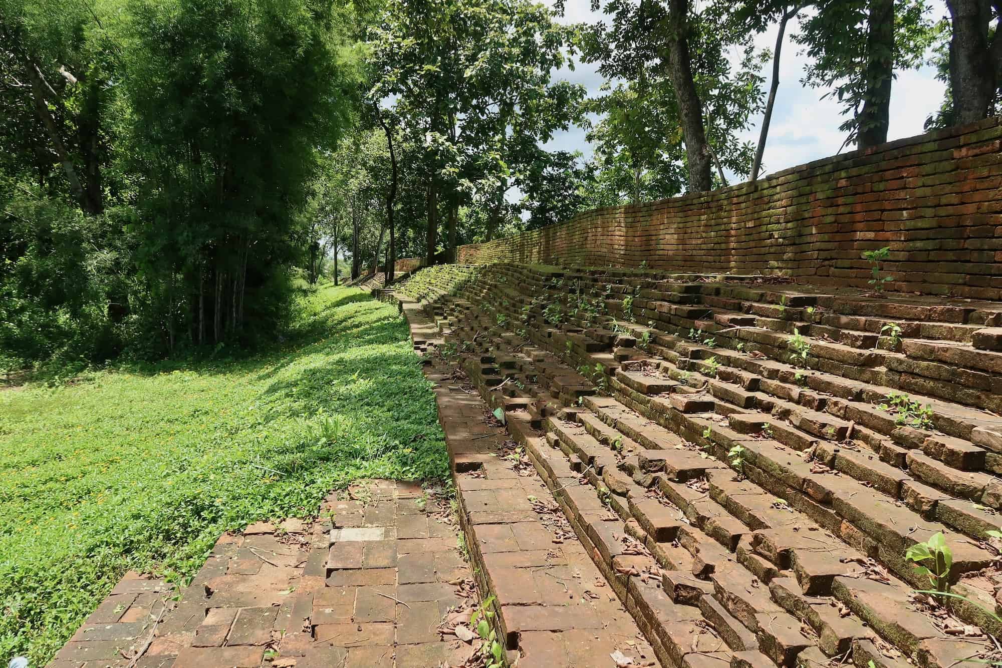
Eastern City Wall Ruins

Of the 2 restored sections of brick wall, the Eastern City Wall is the longest. It is easily found running north off the main street in the city center. This section was more complex than its western counterpart, having multiple steps leading up to a 1-meter-wide platform where soldiers and guards could be stationed.
On the inner section of the brick wall are steps leading to the top for anyone defending the interior to view outside the wall. These steps are each 40 cm high, except for the first step, which is 45 cm high.

Due to centuries of sediment build-up within the city wall mound, archaeologists estimate the ancient Fang living area was actually 1 meter lower than the current ground level inside the wall. The archaeologists who excavated the brick section think there would have been a wooden stairway continuing to this ancient ground level from the bottom of the brick stair.
Western City Wall Ruins

The Western City Wall is harder to reach, but the more impressive of the two remaining sections. It is hidden behind several buildings and trees on an obscure road west of Wat Phrabat Udom. To reach it, you need to walk down a relatively questionable dirt path on an otherwise deserted road.


The western wall section is 140 meters long and is estimated to have originally been a 2-meter high earthen wall built in the 13th-14th century, while the upper brick section was 1.5 meters tall and built in the 15th Century CE.

On the inner section of the brick wall are steps leading to the top for anyone defending the interior to view outside the wall. These steps are each 30cm high, except for the first step, which is 40cm high.
Although the western wall remnants are not easily visible from the interior road or the exterior road running parallel, they are built on a ride and provide a definitive strategic view over anything below and running many miles into the distance.
Wat Phrabat Udom

Wat Phrabat Udom is the most historically significant temple in Fang, supposedly tracing its origins back to the legendary ruler Udom Sin. There is a shrine honoring this king or ruler who was supposedly a contemporary city of Chiang Saen’s royalty, but no other historical documents seem to corroborate this.
However, there are bricks and artifacts found at the site that indicate some form of the temple stood here prior to the Lanna Period.

The first mentions of Wat Phrabat Udom in the Lanna Period occur in 1361 CE, when Prince Boonthawongsa from Chiang Mai renovated the temple by restoring the Phrabat Chedi (Buddha’s footprint stupa) and building a new viharn (worship hall). With this restoration, a new clergy of monks from Chiang Mai was brought to the temple. Since that point, the temple has been continuously occupied, even during the years of the Burmese Occupation of Lanna.
The temple is located between the two remaining sections of Fang’s brick wall fortifications, placing it in the center of the ancient walled city.
Wat Chedi Udom Sin (Wiang Suttho Temple)
Wat Chedi Udom Sin (named after the legendary ancient ruler of Fang) is the only true ruined temple in Fang. It is located in an area north of the main walled city of Fang, named Wiang Suttho (which the temple is alternatively called, too). Today, this area is home to most of the city’s governmental buildings.
The ruins appear very weathered, and consist of a single stupa and the base of a viharn. The stupa is very squared and seems more Burmese in style than Lanna. However, I am unsure of the date or any firsthand information on the temple ruins.
Unfortunately, I didn’t learn of the Wat Chedi Udom Sin ruins until after we had left Fang, so I wasn’t able to visit myself and get photographs. However, you can see photos of the old temple at the Fang government page.
Fang City Pillar Shrine

The Fang city pillar shrine is located almost in the geographic center of the old walled city. This open-air plaza is centered on 3 wooden buildings in a Lanna style surrounded by animal totems and smaller pillars wrapped in colorful cloth. In the center is the actual pillar — a golden pole about shoulder-height enclosed by elephant tusks.

The purpose of the city pillar shrine is to house the spirit deity of a city and ceremonies are performed to ensure the prosperity of the city. These city pillar shrines are located in each provincial capital today and can be found in some other cities around the country as well.
Wat Chedi Ngam

Wat Chedi Ngam is a modern temple, although it might be of interest to those visiting for historic information. The temple is home to a series of murals and carvings depicting the life of Mangrai, the founding king of the Lanna Kingdom.
Otherwise, the temple is mostly what you would expect from any northern Thai temple. IT is surrounded by highly detailed guardian spirit statutes and the interior of the main viharn has some highly detailed wooden carvings.
My Visit to Ancient Fang

Fang made up the first part of a long weekend trip circling through a handful of northern provinces. While we could’ve gotten there by bus, I had begun enjoying the long rides through northern Thailand in a rental car. Although be forewarned if you drive, the mountains between Chiang Dao and Fang are not the simple obstacle they look on the map — but I made the mistake of driving through them at night, too.
Our stay in Fang was brief, and there were no great options for hotels inside of the Old City. Most of the city’s hotels are located on the highway leading to Chaing Mai. We ended up staying at the Fang Modern Hotel, which was beautifully built out into the rice fields.
The next morning, a quick drive into town and we passed through the majority of historical sites within 2 hours. Besides the surrounding countryside, there is not much else in the town for tourists. However, we had a fantastic brunch at the Gafre Café and I would highly recommend it to any visitors.
How to Get to Ancient Fang
GPS Coordinates: 19.92077, 99.21386

Fang is a small town located in the far north of Chiang Mai Province. The town can be easily reached by bus from the popular northern Thailand cities of Chiang Mai (~3 hours) or Chiang Rai (~2 hours). However, the town is spread out, not well set up for tourism, and lacks easy public transit.
Fast Facts
Fast Facts
Name: Ancient Fang
Where: Fang, Chiang Mai, Thailand
Location: 19.92077, 99.21386
Description: Fang is a small town in northern Chiang Mai province that was an early capital of the Lanna Kingdom. It still holds some ruins from its historical eras.
Getting there: Fang can be reached by bus from Chiang Mai and Chiang Rai cities.
Cost: Free
Glossary
Chiang Mai
City in northern Thailand and historic capital of the Lanna Kingdom founded by King Mangrai in 1296.
Chiang Rai
City in northern Thailand founded by the Lanna king Mangrai in 1262 CE.
Chiang Saen
City in northern Thailand and historic capital of the Ngoenyang Kingdom until the establishment of its successor, the Lanna Kingdom, in 1293 CE.
city pillar shrine
Shrine devoted to a city spirit deity where offerings are made for a city’s prosperity
Hariphunchai
Ancient name of Lamphun, Thailand and the historic capital of the Dvaravati Hariphunchai Kingdom.
Hariphunchai Kingdom
Dvaravati kingdom in northern Thailand (c. 750 – 1292 CE) centered in the modern town of Lamphun. Eventually conquered by the Lanna Kingdom.
Khmer Empire
Hindu-Buddhist kingdom which ruled much of Southeast Asia from their capital at Angkor.
Lanna Kingdom
Thai kingdom based in northern Thailand and northwestern Laos. Its capitals included Chiang Rai, Wiang Kum Kam, and Chiang Mai.
Mangrai
Final ruler of the Ngoenyang Kingdom (Chiang Saen) and founder of the Lanna Kingdom from 1291-1311 who established Wiang Kum Kam in 1286 and its successor Chiang Mai in 1293.
Mekong River
The world’s 12th longest river, which flows from the Himalayas through China, Myanmar, Laos, Thailand, Cambodia, and Vetnam, into the Pacific Ocean.
Ngoenyang Kingdom
Tai kingdom based in Chiang Saen, which was succeeded by the Lanna Kingdom after the establishment of Chiang Mai
Pagan Kingdom
Burmese empire that controlled Myanmar from 1044-1297 CE
Sources
- “Ancient City Wall of Fang (The East Side)” informational sign. The 7th Regional Office of Fine Arts, Chiang Mai. Fang, Thailand.
- “Ancient City Wall of Fang (The West Side)” informational sign. The 7th Regional Office of Fine Arts, Chiang Mai. Fang, Thailand.
- Asienreisender. “Fang / Thailand.” Asienreisender, 4 Sept. 2016, www.asienreisender.de/fang.html.
- “History of Wat Phrabat Udom” sign. Wat Phrabat Udom, Fang, Thailand.
- “Phaya Mangrai, The first king of Lanna” display. Chiang Mai Historical Centre, Chiang Mai, Thailand.
- “Phaya Man Grai” display. Chiang Mai National Museum, Chiang Mai, Thailand.
- Svasti, Pichaya. Journey into Antiquity. 22 June 2017, www.bangkokpost.com/travel/1273415/journey-into-antiquity.
- “ Wat Chedi Udomsin Wiang Suttho Archaeological Site (Cultural Attractions) .” อบต.เวียง จ.เชียงใหม่, www.wiang.go.th/index.php?_mod%3DdHJhdmVs%26no%3DNw. (Translation)


