

The Khmer Empire, a Hindu civilization that existed in Cambodia around 800-1200, though recent by archaeological standards, created some of the most spectacular ruins that still exist today. From their center at Angkor Wat, they expanded outward as far north as Isan and as west almost to the Burma border. After their decline, many of their cities and monuments were reclaimed the surrounding jungles, making them one of the legendary, truly lost civilizations.
I had dreamt of seeing these fabled and elaborate ruins for years. Their story truly does have all the elements of one of the great Indiana Jones-explorer era tales. And while I would have liked my first glimpse of them to be the great capitol of Angkor Thom, they were in Cambodia and I could not leave Thailand without voiding my visa. So, Angkor Thom would have to wait.
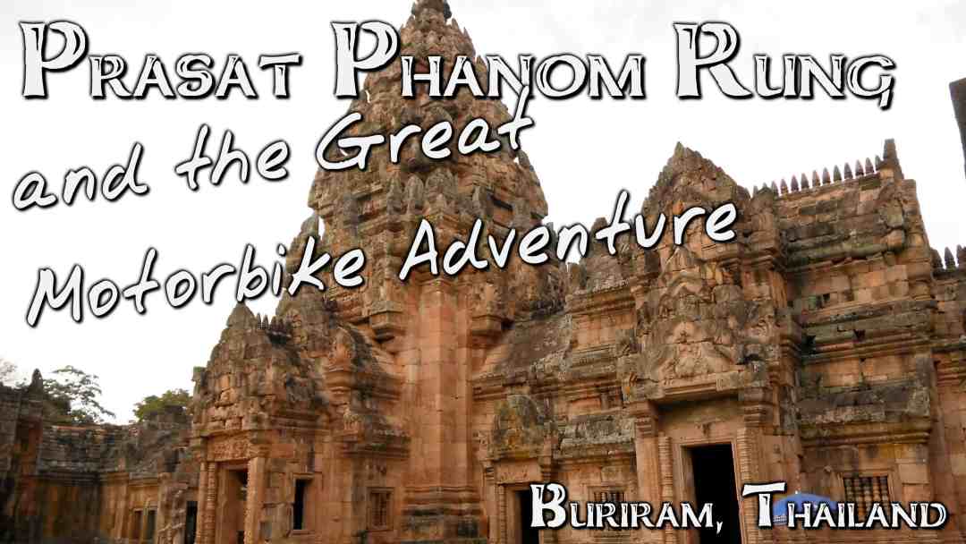
Though scattered ruins dot the Cambodian border area, I had chosen Prasat Phanom Rung, an Angkor temple dedicated to Shiva, the trinity god of destruction. It seemed appropriate enough for a shrine atop an extinct volcano. It is also the largest that Thailand has to offer.
The day began with a small breakfast offered by my hosts at Honey Inn.

Checking the map and guidebook at a gas station.
After that I was off, riding a small automatic motorbike down the major east-west highway that spans the Isan flatlands from Bangkok to Ubon Ratchathani in search of these ruins. That is, until about 20 kilometers in, when I realized I was going in the wrong direction and made a U-turn.
So, after THAT I was off in search of said legendary ruins. At the next town over from Nang Rong, I stopped to fill up the tank, check over my map once more, and headed south toward the Cambodian border.
The map was fairly vague in its scale or relative positions, which added a level of fun to the whole experience. Cruising down the road not knowing how near or far something might be puts the whole experience of discovery a bit more in your own hands.

The extinct volcano of Phanom Rung in the distance.
Still, the path was fairly apparent, since the entire area was flat and only a few lone hills rose out of it. So, ever nearing the largest peak, I was slowly working my way toward Phanom Rung. After my experience going up Doi Suthep in Chiang Mai, I had no doubt I could handle Phanom Rung’s slope.
The “Historical Park” as they are called in Thailand, had 3 entrances. I took the first, which ended up being the back way in. Though, as soon as I saw that central spire imposing over a hill, I parked the bike and began walking.

The walkway leading up to the ruins from where I entered.
A series of roughly placed stone stairs lead up a small hill. They may have been original, though I doubted it, given the lack of care in their placement. But, as soon as I reached their pinnacle, there it was: ruins of the Angkor civilization . . .
I realized very quickly that I hadn’t taken the correct way in, but that didn’t take away from the sheer awe these ruins induced. In front of me stood a massive brown-grey stone wall guarding an inner sanctum built by an extinct culture to a god still worshiped.

And there it was!
One of the more seemingly mundane, though actually very impressive things about the area was the ground. The ornate angular terracing and the pavement. We don’t think much of pavement these days, as it is everywhere and made easily. But in older civilizations, it was rare, and to see a site paved with flattened cut stones is extremely impressive.

Buddhist monks dotting the stairs.
Buddhist monks roamed the grounds, their bright orange robes in sharp contrast to the natural look of the stonework and forest. There were fewer tourists than I expected, and were overwhelmingly Thai, though at a site like this you always hope for fewer than there are. Perhaps if only for that false illusion that you were the first to see something this spectacular.

Monks looking out over the Naga Bridge walkway.
I entered the main gate to the wall of the shrine surprised to find 2 darkened chambers on either side. I had brought a torch with me, but it provided little to help in these rooms. My camera’s flash was the best way to see anything, even if only for a second, I could look at it illuminated on the display. Unfortunately, while high, there was nothing actually in these chambers.
Walking through into the central courtyard proved much more rewarding, as the central shrine, still undergoing excavation, stood before me. All over it were reliefs depicting major tales from the Ramayana.

The whole inner structure.

The central shrine in detail.
For those unfamiliar, reliefs are not the same as inscriptions. Reliefs are raised and inscriptions are sunken. To create and inscription, you only need to chisel into a piece of stone. For a relief, you have to cut the stone all around the picture or writing you intend to make. Therefore, a relief in immensely more impressive.

An ancient Naga sculpture.
I know so many people would come to a place like this and loop through once, maybe take notice of a detail here and there, and then move on. Now, I am by no means qualified for complete commentary on a Hindu archaeological site, but I was trying to seek out every detail in the reliefs, architecture, and stonework that I could possibly find.
And there was so much. Half-emerging structures still in the ground. Amazing reliefs of Rama’s battle against Indrajit. A shrine depicting a knelt cow in the center. I’m usually very skeptical of the unyielding archaeological interpretation “it had a religious significance.” Although in this case, that interpretation was absolutely true.

Monks taking pictures with their bright orange iPhones.
More monks stood inside the central shrine, some praying and others taking pictures with their iPhones, which curiously enough had cases that matched their robes exactly.
One curious thing about the ruins was that they seemed to be made of at least 2 different types of stone. Some, particularly that which made up the wall structure, was very porous. Whether that was the natural state of the rock or simply an effect of weathering, I cannot say. However, many of the base structures and the central shrine was made up of a rock that still had a relatively smooth surface, indicating that either much more care was put into shaping it, that it was a harder mineral overall, or both.
Exiting through the rear gate, I was able to walk along the majority of the outer wall. It seemed to be made of the smoother stone as well.

The view through the rear gate.
Also from outside the wall, I got my first glimpse of the surrounding area from the peak of the volcano in the direction I had come from. The flatlands of the Khorat Plateau became quite apparent there.
Not quite as impressive and the central structures, but still very much so, is the spectacularly paved walkway that spanned close to a half kilometer from the temple itself. Lined with still-standing, equally spaced pillars, it was quite the sight to those willing to appreciate it.

A view down the Naga Bridge Walkway.

And back toward the monument.
When I reached the end of the walkway, I was at the park’s museum and main entrance (AKA, where I should have come in).
Off to the side of the entrance were a slew of souvenir stands (selling things completely unrelated to the site) and a fully functioning Buddhist temple with some very interesting murals on it.
 After a stroll back up the walkway to the temple, the correct way in, I spent another half hour or looking around the main ruins again the then went back down the short slope to my bike.
As I said, the whole area is littered with Angkorian sites, and Phanom Rung may be the most impressive, but I wanted to find any other ones that I could.
So, riding down the mountain, I found myself in a small village (which would turn out to be one of the larger ones, actually), which I had to turn right in, according to my ambiguous map.
I had to keep in mind that, regardless of the fact that I was near popular ruins, I was still on the outskirts of the least populated area of a country that didn’t actually use a Latin alphabet. So, I took what few signs that came in English with great regard.
After a couple exceptionally small villages, and a couple bust side routes looking for stray Angkor ruins, I came to Mueang Tam, a large town for the area whose center contained another Angkor temple-citadel. On top of that it was serviced by a remnant Khmer reservoir.
Parking my motorbike on the grounds of the park itself, I was able to show my admission to Prasat Phanom Rung and get free entrance.
 While smaller and overall less attractive than Phanom Rung, there was something cozy about Mueang Tam that just made it nicer in my view. The partial interior moat. The smaller scale. The more accessible and less intricate carvings.
It central shrine wasn’t a single structure as Phanom Rung was, but rather 4 hollow spires, portions of which were noticeably reconstructed.
On a side note, I have mixed feelings on reconstruction for ancient ruins. On the plus side, they can give the casual visitor, and sometimes even the professional, a better feel of what the place was actually like.
On the other hand, there are problems as well. The most significant is that whoever is leading the reconstruction may get it completely wrong, and in doing so, irreparably damage the site for future excavation study.
 The restored parts were very obvious as the stone was lighter and showed no sign of weathering as the centuries-old stone working did.
Leaving Mueang Tam (and the lone man fishing in its moat) was where the real adventure started though. Going off of my own sense of direction and the vague map, I headed further south toward the Cambodia border, where there were supposed to be more ruins, and a quarry where the lives of many of these stone structures began. For some reason I cannot place my finger on, that interested me more than actually seeing the remaining scattered ruins.

A common sight while riding that day.
What ended up being a far more compelling experience was not actually stumbling across these hidden ruins I was searching for, but rather the lively, yet miniscule villages that arose out of the flatland fields. They were small enough that I would have been through most of these in under 2 minutes if I were even going half speed.
However, I slowed enough to actually take in as much of each village as I could and occasionally diverted to side streets (if they even existed) or stopped to pick up a water or soda at one of the places that weren’t 7-11.

A very isolated but pretty temple I came across in the middle of nowhere.
In one town, as I slowed, everyone that was on the street began waving at me and saying, “Hello” in English. In another, I was forced off the road for a few minutes to make room for a herd of cattle coming through that was actually longer than the whole village.

Everything stops when the cows walk in.
Nearly an hour and a half after leaving Mueang Tam, I finally decided to turn around and retrace my path back. While I thought I had taken the right turns and gone the correct relative distances, I had not yet come across any of the additional sites promised by the map. However, as I said it was hardly detailed enough for specific locations. But, sunset had already started, and I honestly had no idea where I was. And though not entirely sure, I was at least partially certain I had not yet crossed into Cambodia yet.
A tip for anyone riding a motorbike in the fading light, or no light at all: wear glasses or some sort of eye protection. As the air cools and the insects come out they will continue to impact your face in the hundreds, each one feeling like anything from a small needle prick to being repeatedly shot in the face with a pellet gun. But, when they get in your eyes, you may be temporarily blinded until its carcass has been washed out completely. It’s not a fun thing to have to deal with while attempting to drive.
The sad and impractical irony is that if you increase speed to get to your destination quicker and get away from the bugs; the strikes become more intense with every KPH upward.
And then there are not only the insects, but the actual animals as well. I crested the peak of Phanom Rung just as the last of the light was bleeding out of the sky. Just past the main entrance to the ruins, something impacted my lower chest. Immediately reacting, I kept one hand on the handlebars and was able to throw it off with the other arm.
I am still not sure what it was, as it was so near dark and I didn’t stop to look for it. A bird. A bat. Some tree rodent. Unlikely, but possibly even a small monkey. Whatever it was, in our brief struggle, it had scratched my arm severely enough to draw blood from two small lines. If that had been only a little higher and impacted my neck or face, there’s a very good chance that I would have taken a harsh spill onto the ground.
Still, I drove away relatively fine, less being a little shaken, and continued to Nang Rong. About a half hour later, I was back at the Honey Inn eating dinner with the hosts and other guests.


Loved the color of your photo of when you checked your guidebook. So often I would bump into a photo op that was monochrome almost as if i had staged it.
And the photo of the monks looking over the naga bridge is beautiful.
When you visit Angkor Thom you will be awed but also visit the other temples, one whose name doesn’t come to mind, celebrating women’s beauty is chockfull of reliefs that are absolutely breathtaking.
Thanks for bringing back memories and a place in Thailand that I have not visited.